
Introduction
Quick start
Description
WEB MAPSS and data production cycle
Format and naming conventions
Naming conventions
File format
Format of raw MAPSS files
Format of MAPSS files generated using WEB interface
Data availability
Supported products
AERONET
AERONET_AOD
AERONET_SDA
AERONET_INV
MODIS
MOD04_L2 and MYD04_L2
MOD05_L2 and MYD05_L2
MISR
MIL2ASAE
OMI
OMAERUV
POLDER
PxL2TLGC
PxL2TOGC
CALIOP
05kmALay
The Multi-sensor Aerosol Products Sampling System (MAPSS) has been established as a consensus data framework for multi-sensor aerosol validation, intercomparison, and joint analysis. MAPSS supports data products from a variety of sensors and instruments, including ground-based, airborne, and spaceborne, obtained at different locations and time around the globe.
Tip: locations can be entered either manually by typing in location names separated by comma, or by using the location selection dialog that opens by clicking on the "Browse" button.

Tip: Hovering with a mouse pointer over items in the Product, Parameter, Layer, or Measurement would produce a pop-up with a more complete description of the item.

Tip: dates can be either typed in manually using the yyyy-mm-dd format, or by using the calendar dialog that opens by clicking on the calendar icons next to the date range fields.


Tip: "History" button reloads only the results of past trials. To also reload data selection criteria that were used to produce these results, please press "Load Data Selections"; until this button is pressed, the "Data Selection" tab will show the data selection criteria of the most recent results.

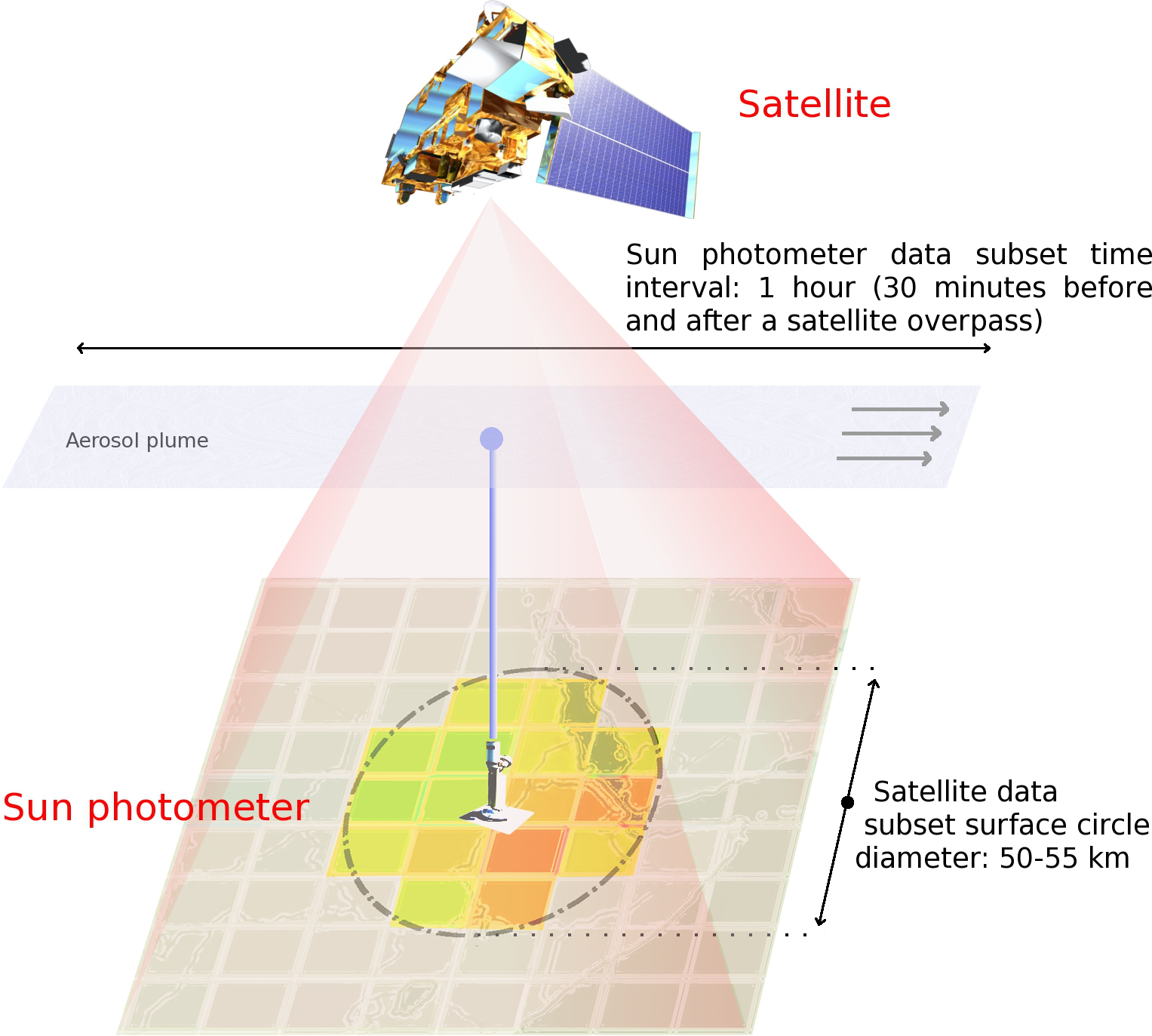
MAPSS provides statistics of spatial and temporal subsets of Level-2 aerosol scientific data sets (SDS) from a range of sensors that currently includes AERONET, MODIS, MISR, OMI, POLDER, and CALIOP.
Certain ground locations, including, but not limited to, the AERONET sun photometer measurement sites, have been identified as focal points for these spatial statistics. The process of generating the statistics for each spatial spaceborne aerosol product involves extracting values of the pixels that fall within an approximate radius of 27.5 km from the chosen locations (see the diagram below). Similarly, statistics for ground-based temporal observations in a particular location are derived from measurements taken within 30 minutes of each satellite overpass over this location.
This subset of pixels for each location is then used to compute the following statistics:
Note that mean, median, deviation, slope, azimuth and correlation are computed only for continuous datasets (i.e., datasets with real numbers). Likewise, mode is computed only for discrete datasets (i.e., datasets with integer numbers). We do not compute standard deviation for a sample if it has only 1 data point. Furhtermore, we do not compute slope, azimuth and correlation if the number of data points in the sample is insufficient to fit a plane; the threshold varies with the resolution of the products.
Statistics for each data product are updated on a daily basis. There is usually, however, a delay of several days between the data availability in a repository for a sensor and its availability in MAPSS, associated with the time required for data retrieval and processing. Also, there are likely to be some data gaps resulting from non-retrieval conditions encountered by the sensors, including clouds in reflective bands, downtime for sensor calibrations etc.
For more information, please refer to the following publications:
MAPSS produces and archives sampled data in a form of comma-separated text files; these files are available for download at http://modis-atmos.gsfc.nasa.gov/MAPSS/. A more interactive access to the sampled data is provided by the WEB-based data customization and plotting interface, http://giovanni.gsfc.nasa.gov/mapss/. Using this interface, it is possible to create a custom file containing one or more datasets of interest, sampled at a specific location and at a specific time. It is also possible to display the selected data on a plot, providing for a rapid data exploration and evaluation process. The MAPSS data production cycle, as well as the relation between MAPSS and WEB MAPSS is explained in the picture below.

The data customization interface of WEB MAPSS consists of 3 main sections: station picker, parameter picker, and date range picker. The pickers can be configured in arbitrary order. Still, a selection made in one of the picker might affect the other pickers; for example, selecting a particular aerosol parameter will limit the date range picker to the production dates of this parameter.
The station (location) picker can be configured manually by typing in names of desired stations separated by comma, or automatically by pressing the "Select" button and choosing stations from the pop-up dialog. In the dialog, multiple stations can be selected by holding "Ctrl" key (on Windows) or "Command" (on Mac) and clicking on the station names of interest.
The parameter picker is configured by progressively selecting aerosol product, parameter (i.e., data set), data set layer, and variable (i.e., measurement statistics or geometry value), and clicking the "Add" button. Explanations of an unfamiliar product/parameter/layer/variable data item can be obtained by hovering mouse over this item; clicking the blue "info" button will open the MAPSS documentation at the section of the selected product. Selected parameters are added to the "Summary" area of the picker, and, if necessary, can be removed by clicking the "Delete" button. Note that the parameter picker has two modes: "Basic" and "Advanced". In the "Basic" mode, only the most popular data sets and variables are shown, while the "Advanced" mode displays the full range of the data sets and variables.
Like the station picker, the date range picker can be also configured either manually by typing in the dates, or automatically by using the provided pop-up dialog. Using the dialog, the date can be selected by clicking on an appropriate day; a month can be adjusted to a next or previous month by clicking the arrows at the top of the dialog; a year can be adjusted by clicking on the year label at the top of the dialog (i.e., between the month selection arrows). Please note that some of the dates in the dialog may be grayed out; this indicates that there is no MAPSS data sampled at these dates for the selected stations and products; in this case, it might be necessary to adjust the selection in the station and parameter pickers.
Once the data picker is configured, the selected data can be plotted and downloaded by clicking one of the "Plot Data" buttons. The produced plot can display up to 3 categories of aerosol parameters; if the selected parameters can not be organized in 3 categories, the system will generate several independent plots. After creating a plot, the selected parameters can be adjusted by clicking back on the data selection tab; after adjusting the parameters, click on the "Plot Data" button again - this will create a new plot. Previously created plots can be reviewed by selecting the appropriate item from the "History" list.
The plotted data can be downloaded as a comma-separated file using the "Download Data" tab on top of the plot page. Note that the produced files can have very long names; if your operating system (e.g., Windows XP) does not support some long file names, please choose a shorter name while saving the file in your browser.
MAPSS provides subset statistics in the form of comma-separated text files, available for direct download at http://modis-atmos.gsfc.nasa.gov/MAPSS/, or thorough the Web-based customization interface. These files are organized in columns, where the name of each column follows the next conventions.
Generally, names of all MAPSS columns are composed from an abbreviation of a dataset name (e.g., AOD stands for Aerosol Optical Depth) and abbreviations for specific parameters within this dataset (e.g., AOD0550sm stands for Aerosol Optical Depth measured at 550nm for particles in small mode); dataset column names can be expected to be unique within a set of MAPSS files produced for a specific aerosol product. For detailed explanations of the column names in a particular product of interest, please refer to an appropriate product section in this document.
Certain column names can be prefixed with abbreviations followed by underscore, signifying a type of statistics reported in this column. For example, sdev_AOD0550sm denotes standard deviation computed for a MAPSS sample of AOD550sm. The prefixes used in MAPSS are as the following:
| cval | Data value in the center of the subset |
| nval | Number of valid subsetting points in the subset |
| mean | Arithmetic mean of the subset |
| sdev | Sample standard deviation of the subset |
| slop | Slope of a plane fitted to the spatial subset, or of a line fitted to the temporal subset |
| slaz | Azimuth of a plane fitted to the spatial subset |
| mcoc | Multiple correlation of the spatial subset |
| lcoc | Linear correlation of the temporal subset |
| medn | Statistical median of the subset |
| mode | Statistical mode of the subset |
There are also several special column names, common to all data products:
| ndat | Total number of the subsetting points in the subset, including ones without valid data |
| orbit | Orbit of the satellite while acquiring data in the subset |
| irowc | Row of the original data file containing the central data point of the subset |
| icolc | Column of the original data file containing the central data point of the subset |
| block | Block of the original data file containing the central data point of the subset |
Raw MAPSS files are available for download at http://modis-atmos.gsfc.nasa.gov/MAPSS/ and have the following format. The header of the file contains information about dataset sampled in this file, as well as input parameters of the MAPSS sampling algorithm. This includes product (PGE) name and version, dataset (SDS) name and description, surface resolution of a single pixel in the dataset, units of measure of the dataset, number of layers in the dataset (e.g., a dataset containing aerosol optical depth can report AOD at several wavelengths), diameter of the surface circle or time interval used for sampling, and maximum number of data points that can fit into the sample.
The line following the header lists data column titles and uses the naming conventions as described above. The remaining lines contain the actual data. In the data block, leftmost columns list auxiliary information, including date and time of the sensor acquiring the central sampling data point (i.e., the time of the overpass), source product file used to produce the sample, sampling location, line and row of the central sampling data point in the source file, total number of data points in the sample (including ones containing a fill value), and number of layers in the dataset. If available, these columns may also include sensor geometry information registered over the central sampling data point, and mode of data quality flags over the entire sampling area.
Important note: because of the special multi-camera sensor architecture, geometry parameters of the MISR MIL2ASAE product are reported in a separate “Geometry” dataset, and are not included in other MAPSS files of this product.
The remaining columns are grouped by dataset layers. For each layer, the columns list a number of statistical parameters as described in the Description section, prefixed by the abbreviations described in the naming conventions section. In the picture below, green shading indicates sampling locations, while orange shading highlights first columns of layer column groups.

*Click on the picture to the see the drawing in the full size
The format of the files generated using Web-based customization interface for MAPSS is the following. The rows 2-3 indicate the range of the dates used to generate the data. The row 4 contains names of ground stations used for the sampling, where each station name cell is followed by a trailing set of empty cells. Please note that all the data located below row 4 under a cell with a station name and its trailing empty cells always belong to a MAPSS sample at this location. Row 5 contains titles for the data columns, and the rest of the rows contain the actual data.
The first column of the data block contains sampling dates, while the rest of the columns are organized in pairs of the form [name of file used to produce a particular data value, the data value]. Naming conventions follow those described in naming conventions section with the exception that the titles also contain product and station names. For example, a pair of column titles [filename_mean_MYD04_L2_051_AOD0550_GSFC, mean_MYD04_L2_051_AOD0550_GSFC] indicates a source file name and a value of aerosol optical depth at 550nm from the MYD05 L2 version 5.1 product at the GSFC location.
In the example picture below, two shades of red indicate two aerosol parameters sampled at the GSFC location, while two shades of green highlight the same two parameters sampled at the SERC location.

*Click on the picture to the see the drawing in the full size
| Product | Version | From | To | Notes |
| AERONET | ||||
| AERONET AOD L2 | 2 | 10/30/1996 | Present | The initial date of the availability reflects the first date it was possible to collocate observations from this product with observations from one of the spaceborne sensor products. Dates of availability vary with the stations. |
| AERONET SDA L2 | 4.1 | 10/30/1996 | Present | |
| AERONET INV L1.5 | 2 | 02/18/1997 | Present | |
| AERONET INV L2 | 2 | 02/24/2000 | Present | |
| AERONET AOD L1.5 | Currently, not supported in MAPSS. | |||
| AERONET SDA L1.5 | ||||
| MODIS | ||||
| MODIS MOD04 L2 | 5 | 02/24/2000 | 04/14/2010 | These products were reprocessed and switched to version 5.1. Version 5 is not produced any more. |
| MODIS MOD05 L2 | 5 | 02/24/2000 | 04/14/2010 | |
| MODIS MOD04 L2 | 5.1 | 02/24/2000 | Present | These products are currently reprocessed by the MODIS team. Certain dates between 2007 and 2010 might not be available yet. |
| MODIS MOD05 L2 | 5.1 | 02/24/2000 | Present | |
| MODIS MYD04 L2 | 5.1 | 07/04/2002 | Present | |
| MODIS MYD05 L2 | 5.1 | 07/04/2002 | Present | |
| MISR | ||||
| MISR MIL2ASAE L2 | 22 | 02/24/2000 | Present | This product is usually delayed for several month in respect to a current date |
| OMI | ||||
| OMI OMAERUV L2 | 3 | 10/01/2004 | Present | |
| POLDER / PARASOL | ||||
| POLDER P1L2TLGC L2 | H | 10/30/1996 | 06/29/1997 | |
| POLDER P1L2TOGC L2 | H | 10/30/1996 | 06/29/1997 | |
| POLDER P2L2TLGC L2 | C | 04/02/2003 | 10/24/2003 | |
| POLDER P2L2TOGC L2 | C | 04/02/2003 | 10/24/2003 | |
| POLDER P3L2TLGC L2 | J | 03/05/2005 | 09/30/2006 | On 10/01/2006, version J was switched to version K. The data collected before 10/01/2006 was not reprocessed to version K. |
| POLDER P3L2TLGC L2 | K | 10/02/2006 | Present | |
| POLDER P3L2TOGC L2 | J | 03/05/2005 | 09/30/2006 | |
| POLDER P3L2TOGC L2 | K | 10/02/2006 | Present | |
| CALIOP | ||||
| CALIOP 05kmALay L2 | 3.01 | 06/07/2006 | Present | |
The AERONET (AErosol RObotic NETwork) program is a federation of ground-based remote sensing aerosol networks established by NASA and PHOTONS (Univ. of Lille 1, CNES, and CNRS-INSU), and is greatly expanded by collaborators from national agencies, institutes, universities, individual scientists, and partners. The program provides a long-term, continuous and readily accessible public domain database of aerosol optical, microphysical and radiative properties for aerosol research and characterization, validation of satellite retrievals, and synergism with other databases. The network imposes standardization of instruments, calibration, processing and distribution.
MAPSS supports three AERONET aerosol products: the standard AERONET AOD product, the AERONET SDA spectral deconvolution product, and the AERONET INV inversion product.
MAPSS processes two levels of AERONET data: Level 1.5 (cloud-screened data) and Level 2 (cloud-screened, re-calibrated and quality assured data). While Level 2 is more accurate and suitable for research, its availability may be significantly delayed; on the other hand, Level 1.5 data are less reliable, but are available within hours of a measurement and appears in MAPSS much faster.
IMPORTANT NOTE: Some of the measurements in the original AERONET data files are reported for several adjacent wavelengths (e.g., 439 and 440 nm), where only one of these wavelengths actually contains data, or is reported for one of the closely adjacent wavelengths that vary depending on the file. MAPSS aggregates this wide set of AERONET wavelengths into a smaller set using the following lookup table:
| MAPSS wavelength | AERONET wavelength range |
| 340 | 330-340 |
| 350 | 350-355 |
| 380 | 380-389 |
| 410 | 410-412 |
| 440 | 437-446 |
| 470 | 470 |
| 490 | 490 |
| 500 | 500 |
| 530 | 530-532 |
| 550 | 550-558 |
| 660 | 660 |
| 670 | 667-677 |
| 870 | 860-873 |
| 1020 | 1016-1023 |
| 1060 | 1060 |
| 1200 | 1200 |
| 1380 | 1380 |
| 1600 | 1600 |
| 1640 | 1640 |
AERONET AOD (AOT) is a collection of the standard AERONET sun photometer aerosol products obtained by direct measurement of solar radiance.
*IMPORTANT NOTE: MAPSS includes the "AerosolOpticalDepthInterpolated" dataset that is a derived product, produced in MAPSS by interpolating the original AERONET AOD data using the quadratic fit on log-log scale (Eck et al, 1999). It is not supported by AERONET team, and designated strictly for validation purposes; furthermore, the interpolated data might have certain inaccuracies, inherent to the process of interpolation..
| MAPSS Header | Explanations | Scientific Data Set (SDS) |
| AOD1640 | Aerosol optical depth at 1640nm | AerosolOpticalDepth |
| AOD1020 | Aerosol optical depth at 1020nm | AerosolOpticalDepth |
| AOD0870 | Aerosol optical depth at 870nm | AerosolOpticalDepth |
| AOD0670 | Aerosol optical depth at 670nm | AerosolOpticalDepth |
| AOD0550 | Aerosol optical depth at 550nm | AerosolOpticalDepth |
| AOD0530 | Aerosol optical depth at 530nm | AerosolOpticalDepth |
| AOD0500 | Aerosol optical depth at 500nm | AerosolOpticalDepth |
| AOD0490 | Aerosol optical depth at 490nm | AerosolOpticalDepth |
| AOD0440 | Aerosol optical depth at 440nm | AerosolOpticalDepth |
| AOD0410 | Aerosol optical depth at 410nm | AerosolOpticalDepth |
| AOD0380 | Aerosol optical depth at 380nm | AerosolOpticalDepth |
| AOD0340 | Aerosol optical depth at 340nm | AerosolOpticalDepth |
| AOD2100intrp | Aerosol optical depth at 2100nm (interpolated) | AerosolOpticalDepthInterpolated* |
| AOD1600intrp | Aerosol optical depth at 1600nm (interpolated) | AerosolOpticalDepthInterpolated* |
| AOD1380intrp | Aerosol optical depth at 1380nm (interpolated) | AerosolOpticalDepthInterpolated* |
| AOD1200intrp | Aerosol optical depth at 1200nm (interpolated) | AerosolOpticalDepthInterpolated* |
| AOD1064intrp | Aerosol optical depth at 1064nm (interpolated) | AerosolOpticalDepthInterpolated* |
| AOD0870intrp | Aerosol optical depth at 870nm (interpolated) | AerosolOpticalDepthInterpolated* |
| AOD0866intrp | Aerosol optical depth at 866nm (interpolated) | AerosolOpticalDepthInterpolated* |
| AOD0865intrp | Aerosol optical depth at 865nm (interpolated) | AerosolOpticalDepthInterpolated* |
| AOD0860intrp | Aerosol optical depth at 860nm (interpolated) | AerosolOpticalDepthInterpolated* |
| AOD0672intrp | Aerosol optical depth at 672nm (interpolated) | AerosolOpticalDepthInterpolated* |
| AOD0670intrp | Aerosol optical depth at 670nm (interpolated) | AerosolOpticalDepthInterpolated* |
| AOD0660intrp | Aerosol optical depth at 660nm (interpolated) | AerosolOpticalDepthInterpolated* |
| AOD0558intrp | Aerosol optical depth at 558nm (interpolated) | AerosolOpticalDepthInterpolated* |
| AOD0555intrp | Aerosol optical depth at 555nm (interpolated) | AerosolOpticalDepthInterpolated* |
| AOD0550intrp | Aerosol optical depth at 550nm (interpolated) | AerosolOpticalDepthInterpolated* |
| AOD0532intrp | Aerosol optical depth at 532nm (interpolated) | AerosolOpticalDepthInterpolated* |
| AOD0470intrp | Aerosol optical depth at 470nm (interpolated) | AerosolOpticalDepthInterpolated* |
| AOD0446intrp | Aerosol optical depth at 446nm (interpolated) | AerosolOpticalDepthInterpolated* |
| AOD0443intrp | Aerosol optical depth at 443nm (interpolated) | AerosolOpticalDepthInterpolated* |
| AOD0412intrp | Aerosol optical depth at 412nm (interpolated) | AerosolOpticalDepthInterpolated* |
| AOD0388intrp | Aerosol optical depth at 388nm (interpolated) | AerosolOpticalDepthInterpolated* |
| AOD0354intrp | Aerosol optical depth at 354nm (interpolated) | AerosolOpticalDepthInterpolated* |
| TripVar1640 | Triplet variability of aerosol optical depth at 1640nm multiplied by 100 | TripletVariability |
| TripVar1020 | Triplet variability of aerosol optical depth at 1020nm multiplied by 100 | TripletVariability |
| TripVar0870 | Triplet variability of aerosol optical depth at 870nm multiplied by 100 | TripletVariability |
| TripVar0670 | Triplet variability of aerosol optical depth at 670nm multiplied by 100 | TripletVariability |
| TripVar0550 | Triplet variability of aerosol optical depth at 550nm multiplied by 100 | TripletVariability |
| TripVar0530 | Triplet variability of aerosol optical depth at 530nm multiplied by 100 | TripletVariability |
| TripVar0500 | Triplet variability of aerosol optical depth at 500nm multiplied by 100 | TripletVariability |
| TripVar0490 | Triplet variability of aerosol optical depth at 490nm multiplied by 100 | TripletVariability |
| TripVar0440 | Triplet variability of aerosol optical depth at 440nm multiplied by 100 | TripletVariability |
| TripVar0410 | Triplet variability of aerosol optical depth at 410nm multiplied by 100 | TripletVariability |
| TripVar0380 | Triplet variability of aerosol optical depth at 380nm multiplied by 100 | TripletVariability |
| TripVar0340 | Triplet variability of aerosol optical depth at 340nm multiplied by 100 | TripletVariability |
| WaterVapor | Water vapor | WaterVapor |
| WateVaporError | Error in water vapor | WaterVaporError |
| Aexp0440-0870 | Angstrom exponent for 440-870nm | AngstromExponent |
| Aexp0380-0500 | Angstrom exponent for 380-500nm | AngstromExponent |
| Aexp0440-0670 | Angstrom exponent for 440-670nm | AngstromExponent |
| Aexp0500-0870 | Angstrom exponent for 550-870nm | AngstromExponent |
| Aexp0340-0440 | Angstrom exponent for 340-440nm | AngstromExponent |
| Aexp0440-0670pl | Angstrom exponent for 440-670nm (Polar) | AngstromExponent |
| SolarZenith | Solar zenith angle | SolarZenithAngle |
The AERONET SDA data product is produced by a spectral deconvolution algorithm based on the standard AERONET measurements. The algorithm enables discrimination of particles in fine and coarse modes, which is not available in the standard AERONET AOD product. Since only some of the standard AERONET measurements are suitable for SDA, the SDA product has a significantly smaller number of data points than the standard AERONET AOD product.
| MAPSS Header | Explanations | Scientific Data Set (SDS) |
| AOD0500t | Aerosol optical depth at 500nm - total | AerosolOpticalDepth500nm |
| AOD0500f | Aerosol optical depth at 500nm - small mode | AerosolOpticalDepth500nm |
| AOD0500c | Aerosol optical depth at 500nm - large mode | AerosolOpticalDepth500nm |
| FMfrac0500 | Fine mode fraction at 500nm | FineModeFraction500nm |
| rfitErrAOD0500t | 2nd order regression fit error for aerosol optical depth at 500nm | RegFitErrorAerosolOpticalDepth500nm |
| rmseAOD0500f | Root mean square error of aerosol optical depth at 500nm - small mode | RMSEAerosolOpticalDepth500nm |
| rmseAOD0500c | Root mean square error of aerosol optical depth at 500nm - large mode | RMSEAerosolOpticalDepth500nm |
| rmseFMfrac0500 | Root mean square error of fine mode fraction at 500nm | RMSEFineModeFraction500nm |
| Aexp0500t | Angstrom exponent at 500nm - total | AngstromExponent500nm |
| Aexp0500f | Angstrom exponent at 500nm - small mode | AngstromExponent500nm |
| slopeAexp0500t | Slope of Angstrom exponent dAE/dln(wavelength) at 500nm - total | AngstromExponentSlope500nm |
| slopeAexp0500f | Slope of Angstrom exponent dAE/dln(wavelength) at 500nm - small mode | AngstromExponentSlope500nm |
| SolarZenith | Solar zenith angle | SolarZenithAngle |
| AirMass | Air mass | AirMass |
| AOD0870inp | Input AOD to the spectral deconvolution algorithm at 870nm | InputAerosolOpticalDepth |
| AOD0670inp | Input AOD to the spectral deconvolution algorithm at 670nm | InputAerosolOpticalDepth |
| AOD0550inp | Input AOD to the spectral deconvolution algorithm at 550nm | InputAerosolOpticalDepth |
| AOD0530inp | Input AOD to the spectral deconvolution algorithm at 530nm | InputAerosolOpticalDepth |
| AOD0500inp | Input AOD to the spectral deconvolution algorithm at 500nm | InputAerosolOpticalDepth |
| AOD0490inp | Input AOD to the spectral deconvolution algorithm at 490nm | InputAerosolOpticalDepth |
| AOD0440inp | Input AOD to the spectral deconvolution algorithm at 440nm | InputAerosolOpticalDepth |
| AOD0410inp | Input AOD to the spectral deconvolution algorithm at 410nm | InputAerosolOpticalDepth |
| AOD0380inp | Input AOD to the spectral deconvolution algorithm at 380nm | InputAerosolOpticalDepth |
The AERONET INV aerosol product is computed with the help of an inversion algorithm that, based on a limited set of measured aerosol properties, estimates possible values for other aerosol properties. Unlike AERONET SDA product, the INV product is computed from the measurements collected, in addition to the standard measurements of AERONET. In this way, the inversion product provides the most complete set of aerosol parameters, but with the smallest number of available data points.
*IMPORTANT NOTE: MAPSS includes the "AerosolOpticalDepthInterpolated" dataset that is a derived product, produced in MAPSS by interpolating the original AERONET AOD data using the quadratic fit on log-log scale (Eck et al, 1999). It is not supported by AERONET team, and designated strictly for validation purposes; furthermore, the interpolated data might have certain inaccuracies, inherent to the process of interpolation.
| MAPSS Header | Explanations | Scientific Data Set (SDS) |
| AOD1640 | Aerosol optical depth at 1640nm | AerosolOpticalDepth |
| AOD1020 | Aerosol optical depth at 1020nm | AerosolOpticalDepth |
| AOD0870 | Aerosol optical depth at 870nm | AerosolOpticalDepth |
| AOD0670 | Aerosol optical depth at 670nm | AerosolOpticalDepth |
| AOD0550 | Aerosol optical depth at 550nm | AerosolOpticalDepth |
| AOD0530 | Aerosol optical depth at 530nm | AerosolOpticalDepth |
| AOD0500 | Aerosol optical depth at 500nm | AerosolOpticalDepth |
| AOD0490 | Aerosol optical depth at 490nm | AerosolOpticalDepth |
| AOD0440 | Aerosol optical depth at 440nm | AerosolOpticalDepth |
| AOD0410 | Aerosol optical depth at 410nm | AerosolOpticalDepth |
| AOD0380 | Aerosol optical depth at 380nm | AerosolOpticalDepth |
| AOD0340 | Aerosol optical depth at 340nm | AerosolOpticalDepth |
| AOD2100intrp | Aerosol optical depth at 2100nm (interpolated) | AerosolOpticalDepthInterpolated* |
| AOD1600intrp | Aerosol optical depth at 1600nm (interpolated) | AerosolOpticalDepthInterpolated* |
| AOD1380intrp | Aerosol optical depth at 1380nm (interpolated) | AerosolOpticalDepthInterpolated* |
| AOD1200intrp | Aerosol optical depth at 1200nm (interpolated) | AerosolOpticalDepthInterpolated* |
| AOD1064intrp | Aerosol optical depth at 1064nm (interpolated) | AerosolOpticalDepthInterpolated* |
| AOD0870intrp | Aerosol optical depth at 870nm (interpolated) | AerosolOpticalDepthInterpolated* |
| AOD0866intrp | Aerosol optical depth at 866nm (interpolated) | AerosolOpticalDepthInterpolated* |
| AOD0865intrp | Aerosol optical depth at 865nm (interpolated) | AerosolOpticalDepthInterpolated* |
| AOD0860intrp | Aerosol optical depth at 860nm (interpolated) | AerosolOpticalDepthInterpolated* |
| AOD0672intrp | Aerosol optical depth at 672nm (interpolated) | AerosolOpticalDepthInterpolated* |
| AOD0670intrp | Aerosol optical depth at 670nm (interpolated) | AerosolOpticalDepthInterpolated* |
| AOD0660intrp | Aerosol optical depth at 660nm (interpolated) | AerosolOpticalDepthInterpolated* |
| AOD0558intrp | Aerosol optical depth at 558nm (interpolated) | AerosolOpticalDepthInterpolated* |
| AOD0555intrp | Aerosol optical depth at 555nm (interpolated) | AerosolOpticalDepthInterpolated* |
| AOD0550intrp | Aerosol optical depth at 550nm (interpolated) | AerosolOpticalDepthInterpolated* |
| AOD0532intrp | Aerosol optical depth at 532nm (interpolated) | AerosolOpticalDepthInterpolated* |
| AOD0470intrp | Aerosol optical depth at 470nm (interpolated) | AerosolOpticalDepthInterpolated* |
| AOD0446intrp | Aerosol optical depth at 446nm (interpolated) | AerosolOpticalDepthInterpolated* |
| AOD0443intrp | Aerosol optical depth at 443nm (interpolated) | AerosolOpticalDepthInterpolated* |
| AOD0412intrp | Aerosol optical depth at 412nm (interpolated) | AerosolOpticalDepthInterpolated* |
| AOD0388intrp | Aerosol optical depth at 388nm (interpolated) | AerosolOpticalDepthInterpolated* |
| AOD0354intrp | Aerosol optical depth at 354nm (interpolated) | AerosolOpticalDepthInterpolated* |
| WaterVapor | Water vapor | WaterVapor |
| AODext0440t | Extinction aerosol optical depth at 440nm - total | AerosolOpticalDepthExtinction |
| AODext0670t | Extinction aerosol optical depth at 670nm - total | AerosolOpticalDepthExtinction |
| AODext0870t | Extinction aerosol optical depth at 870nm - total | AerosolOpticalDepthExtinction |
| AODext1020t | Extinction aerosol optical depth at 1020nm - total | AerosolOpticalDepthExtinction |
| AODext0440f | Extinction aerosol optical depth at 440nm - small mode | AerosolOpticalDepthExtinction |
| AODext0670f | Extinction aerosol optical depth at 670nm - small mode | AerosolOpticalDepthExtinction |
| AODext0870f | Extinction aerosol optical depth at 870nm - small mode | AerosolOpticalDepthExtinction |
| AODext1020f | Extinction aerosol optical depth at 1020nm - small mode | AerosolOpticalDepthExtinction |
| AODext0440c | Extinction aerosol optical depth at 440nm - large mode | AerosolOpticalDepthExtinction |
| AODext0670c | Extinction aerosol optical depth at 670nm - large mode | AerosolOpticalDepthExtinction |
| AODext0870c | Extinction aerosol optical depth at 870nm - large mode | AerosolOpticalDepthExtinction |
| AODext1020c | Extinction aerosol optical depth at 1020nm - large mode | AerosolOpticalDepthExtinction |
| AE0870-0440t | Angstrom exponent for 870-440nm | AngstromExponent |
| AE0870-0440abs | Angstrom exponent for 870-440nm - absorption | AngstromExponent |
| SSA0440t | Single scattering albedo at 440nm - total | SingleScatteringAlbedo |
| SSA0670t | Single scattering albedo at 670nm - total | SingleScatteringAlbedo |
| SSA0870t | Single scattering albedo at 870nm - total | SingleScatteringAlbedo |
| SSA1020t | Single scattering albedo at 1020nm - total | SingleScatteringAlbedo |
| AAOD0440t | Absorption aerosol optical depth at 440nm - total | AerosolOpticalDepthAbsorption |
| AAOD0670t | Absorption aerosol optical depth at 670nm - total | AerosolOpticalDepthAbsorption |
| AAOD0870t | Absorption aerosol optical depth at 870nm - total | AerosolOpticalDepthAbsorption |
| AAOD1020t | Absorption aerosol optical depth at 1020nm - total | AerosolOpticalDepthAbsorption |
| RIre0440 | Refractive index at 440nm - real part | RefractiveIndex |
| RIre0670 | Refractive index at 670nm - real part | RefractiveIndex |
| RIre0870 | Refractive index at 870nm - real part | RefractiveIndex |
| RIre01020 | Refractive index at 1020nm - real part | RefractiveIndex |
| RIim0440 | Refractive index at 440nm - imaginary part | RefractiveIndex |
| RIim0670 | Refractive index at 670nm - imaginary part | RefractiveIndex |
| RIim0870 | Refractive index at 870nm - imaginary part | RefractiveIndex |
| RIim1020 | Refractive index at 1020nm - imaginary part | RefractiveIndex |
| ASYM0440t | Asymmetry factor at 440nm - total | AsymmetryFactor |
| ASYM0670t | Asymmetry factor at 670nm - total | AsymmetryFactor |
| ASYM0870t | Asymmetry factor at 870nm - total | AsymmetryFactor |
| ASYM1020t | Asymmetry factor at 1020nm - total | AsymmetryFactor |
| ASYM0440f | Asymmetry factor at 440nm - small mode | AsymmetryFactor |
| ASYM0670f | Asymmetry factor at 670nm - small mode | AsymmetryFactor |
| ASYM0870f | Asymmetry factor at 870nm - small mode | AsymmetryFactor |
| ASYM1020f | Asymmetry factor at 1020nm - small mode | AsymmetryFactor |
| ASYM0440c | Asymmetry factor at 440nm - large mode | AsymmetryFactor |
| ASYM0670c | Asymmetry factor at 670nm - large mode | AsymmetryFactor |
| ASYM0870c | Asymmetry factor at 870nm - large mode | AsymmetryFactor |
| ASYM1020c | Asymmetry factor at 1020nm - large mode | AsymmetryFactor |
| SizeBin1 | Size distribution [dV(r)/dln r] - bin with the center in 0.05um (logarithmic scale) | SizeDistribution |
| SizeBin2 | Size distribution [dV(r)/dln r] - bin with the center in 0.065604um (logarithmic scale) | SizeDistribution |
| SizeBin3 | Size distribution [dV(r)/dln r] - bin with the center in 0.086077um (logarithmic scale) | SizeDistribution |
| SizeBin4 | Size distribution [dV(r)/dln r] - bin with the center in 0.112939um (logarithmic scale) | SizeDistribution |
| SizeBin5 | Size distribution [dV(r)/dln r] - bin with the center in 0.148184um (logarithmic scale) | SizeDistribution |
| SizeBin6 | Size distribution [dV(r)/dln r] - bin with the center in 0.194429um (logarithmic scale) | SizeDistribution |
| SizeBin7 | Size distribution [dV(r)/dln r] - bin with the center in 0.255105um (logarithmic scale) | SizeDistribution |
| SizeBin8 | Size distribution [dV(r)/dln r] - bin with the center in 0.334716um (logarithmic scale) | SizeDistribution |
| SizeBin9 | Size distribution [dV(r)/dln r] - bin with the center in 0.439173um (logarithmic scale) | SizeDistribution |
| SizeBin10 | Size distribution [dV(r)/dln r] - bin with the center in 0.576227um (logarithmic scale) | SizeDistribution |
| SizeBin11 | Size distribution [dV(r)/dln r] - bin with the center in 0.756052um (logarithmic scale) | SizeDistribution |
| SizeBin12 | Size distribution [dV(r)/dln r] - bin with the center in 0.991996um (logarithmic scale) | SizeDistribution |
| SizeBin13 | Size distribution [dV(r)/dln r] - bin with the center in 1.301571um (logarithmic scale) | SizeDistribution |
| SizeBin14 | Size distribution [dV(r)/dln r] - bin with the center in 1.707757um (logarithmic scale) | SizeDistribution |
| SizeBin15 | Size distribution [dV(r)/dln r] - bin with the center in 2.240702um (logarithmic scale) | SizeDistribution |
| SizeBin16 | Size distribution [dV(r)/dln r] - bin with the center in 2.939966um (logarithmic scale) | SizeDistribution |
| SizeBin17 | Size distribution [dV(r)/dln r] - bin with the center in 3.857452um (logarithmic scale) | SizeDistribution |
| SizeBin18 | Size distribution [dV(r)/dln r] - bin with the center in 5.06126um (logarithmic scale) | SizeDistribution |
| SizeBin19 | Size distribution [dV(r)/dln r] - bin with the center in 6.640745um (logarithmic scale) | SizeDistribution |
| SizeBin20 | Size distribution [dV(r)/dln r] - bin with the center in 8.713145um (logarithmic scale) | SizeDistribution |
| SizeBin21 | Size distribution [dV(r)/dln r] - bin with the center in 11.432287um (logarithmic scale) | SizeDistribution |
| SizeBin22 | Size distribution [dV(r)/dln r] - bin with the center in 15um (logarithmic scale) | SizeDistribution |
| InflectionPoint | Inflection point separating fine and coarse modes | InflectionPoint |
| VolConct | Volume concentration - total | VolumeConcentration |
| VolConcf | Volume concentration - small mode | VolumeConcentration |
| VolConcc | Volume concentration - large mode | VolumeConcentration |
| EffRadt | Effective radius - total | EffectiveRadius |
| EffRadf | Effective radius - small mode | EffectiveRadius |
| EffRadc | Effective radius - large mode | EffectiveRadius |
| VolMedRadt | Volume median radius - total | VolumeMedianRadius |
| VolMedRadf | Volume median radius - small mode | VolumeMedianRadius |
| VolMedRadc | Volume median radius - large mode | VolumeMedianRadius |
| StdDevt | Standard deviation from volume median radius - total | StandardDeviation |
| StdDevf | Standard deviation from volume median radius - small mode | StandardDeviation |
| StdDevc | Standard deviation from volume median radius - large mode | StandardDeviation |
| altBOA | Altitude - bottom of the atmosphere | Altitude |
| altTOA | Altitude - top of the atmosphere | Altitude |
| FluxBbDnBOA | Downward broadband flux at bottom of the atmosphere | BroadbandFlux |
| FluxBbDnTOA | Downward broadband flux at top of the atmosphere | BroadbandFlux |
| FluxBbUpBOA | Upward broadband flux at bottom of the atmosphere | BroadbandFlux |
| FluxBbUpTOA | Upward broadband flux at top of the atmosphere | BroadbandFlux |
| frcnboa | Radiative forcing at bottom of the atmosphere | RadiativeForcing |
| frcntoa | Radiative forcing at top of the atmosphere | RadiativeForcing |
| FrcnEffcBOA | Radiative forcing efficiency at bottom of the atmosphere | RadiativeForcingEfficiency |
| FrcnEffcTOA | Radiative forcing efficiency at top of the atmosphere | RadiativeForcingEfficiency |
| FluxSpDn0440tot | Downward spectral flux at 440nm - total | SpectralFlux |
| FluxSpDn0670tot | Downward spectral flux at 670nm - total | SpectralFlux |
| FluxSpDn0870tot | Downward spectral flux at 870nm - total | SpectralFlux |
| FluxSpDn1020tot | Downward spectral flux at 1020nm - total | SpectralFlux |
| FluxSpUp0440tot | Upward spectral flux at 440nm - total | SpectralFlux |
| FluxSpUp0670tot | Upward spectral flux at 670nm - total | SpectralFlux |
| FluxSpUp0870tot | Upward spectral flux at 870nm - total | SpectralFlux |
| FluxSpUp1020tot | Upward spectral flux at 1020nm - total | SpectralFlux |
| FluxSpDfs0440tot | Diffuse spectral flux at 440nm - total | SpectralFlux |
| FluxSpDfs0670tot | Diffuse spectral flux at 670nm - total | SpectralFlux |
| FluxSpDfs0870tot | Diffuse spectral flux at 870nm - total | SpectralFlux |
| FluxSpDfs1020tot | Diffuse spectral flux at 1020nm - total | SpectralFlux |
| almType | Almucantar type (data level identifier) | AlmucantarType |
| SolarZenithBtwnAlm1020 | Solar zenith angle for 1020nm channel (average between left and right almucantars) | SolarZenithAngleBtwnAlm |
| SkyErr | Sky error | SkySunError |
| SunErr | Sun error | SkySunError |
| AExp0440-0870 | Angstrom exponent | Alpha |
| AOD0440msrd | Aerosol optical depth | Tau |
| SpherParm | Sphericity parameter | SphericityParameter |
| ScatteringAngle0440_3to6 | Scattering angle (>=3.2 to 6) at 440nm | ScatteringAngle |
| ScatteringAngle0440_6to30 | Scattering angle (>=6 to 30) at 440nm | ScatteringAngle |
| ScatteringAngle0440_30to80 | Scattering angle (>=30 to 80) at 440nm | ScatteringAngle |
| ScatteringAngle0440_grt80 | Scattering angle (>=80) at 440nm | ScatteringAngle |
| ScatteringAngle0670_3to6 | Scattering angle (>=3.2 to 6) at 670nm | ScatteringAngle |
| ScatteringAngle0670_6to30 | Scattering angle (>=6 to 30) at 670nm | ScatteringAngle |
| ScatteringAngle0670_30to80 | Scattering angle (>=30 to 80) at 670nm | ScatteringAngle |
| ScatteringAngle0670_grt80 | Scattering angle (>=80) at 670nm | ScatteringAngle |
| ScatteringAngle0870_3to6 | Scattering angle (>=3.2 to 6) at 870nm | ScatteringAngle |
| ScatteringAngle0870_6to30 | Scattering angle (>=6 to 30) at 870nm | ScatteringAngle |
| ScatteringAngle0870_30to80 | Scattering angle (>=30 to 80) at 870nm | ScatteringAngle |
| ScatteringAngle0870_grt80 | Scattering angle (>=80) at 870nm | ScatteringAngle |
| ScatteringAngle1020_3to6 | Scattering angle (>=3.2 to 6) at 1020nm | ScatteringAngle |
| ScatteringAngle1020_6to30 | Scattering angle (>=6 to 30) at 1020nm | ScatteringAngle |
| ScatteringAngle1020_30to80 | Scattering angle (>=30 to 80) at 1020nm | ScatteringAngle |
| ScatteringAngle1020_grt80 | Scattering angle (>=80) at 1020nm | ScatteringAngle |
| Albedo0440 | Spectral albedo at 440nm | SpectralAlbedo |
| Albedo0670 | Spectral albedo at 670nm | SpectralAlbedo |
| Albedo0870 | Spectral albedo at 870nm | SpectralAlbedo |
| Albedo1020 | Spectral albedo at 1020nm | SpectralAlbedo |
| SolzenForFluxClc | Average solar zenith angle used for broadband flux calculation | AverageSolarZenithForFluxCalc |
MODIS (or Moderate Resolution Imaging Spectroradiometer) is a key instrument aboard the Terra (EOS AM) and Aqua (EOS PM) satellites. Terra's orbit around the Earth is timed so that it passes from north to south across the equator in the morning, while Aqua passes south to north over the equator in the afternoon. Terra MODIS and Aqua MODIS view the entire Earth's surface every 1 to 2 days, acquiring data in 36 spectral bands, or groups of wavelengths (see MODIS Technical Specifications).
Depending on the satellite, MODIS products have a MODXX (Terra) or MYDXX (Aqua) designation, where XX is a two-digit number identifying a product. MAPSS samples two Level-2 MODIS aerosol and water vapor products: MOD04 (MYDo4) and MOD05 (MYD05).
When working with MODIS data, it is important to pay attention to Quality Assurance (QA) flags supplied with the data. Particularly, MODIS adopts the following data quality conventions:
Depending on the MODIS product, one of the three flags should be used:
MOD04 and MYD04 are aerosol products produced by the MODIS instrument on board the Terra (MOD) and Aqua (MYD) satellites. The MODIS Aerosol Product monitors the ambient aerosol optical thickness over the oceans globally, and over a portion of the continents.
Datasets in this product are split into two groups - the standard data sets and Deep Blue data sets. Deep Blue data is computed over bright land surfaces (e.g., deserts), where the standard algorithm is not applicable.
Notes:
| MAPSS Header | Explanations | Scientific Data Set (SDS) |
| lon | Geodetic longitude | Longitude |
| lat | Geodetic latitude | Latitude |
| sstime | TAI time at start of scan replicated across the swath | Scan_Start_Time |
| solz | Solar zenith angle, cell to sun | Solar_Zenith |
| sola | Solar azimuth angle, cell to sun | Solar_Azimuth |
| senz | Sensor zenith angle, cell to sensor | Sensor_Zenith |
| sena | Sensor azimuth angle, cell to sun | Sensor_Azimuth |
| cmqa | Cloud mask info on 10x10 km resolution | Cloud_Mask_QA |
| scang | Scattering angle | Scattering_Angle |
| scang-l | Scattering angle for land | Scattering_Angle_Land |
| scang-o | Scattering angle for ocean | Scattering_Angle_Ocean |
| AOD0550 | Aerosol optical depth at 550nm with best quality data (Quality flag=3) for both ocean (best) and land (corrected) | Optical_Depth_Land_And_Ocean |
| rAODse0550 | Ratio of small mode optical depth at 550nm for land and ocean | Optical_Depth_Ratio_Small_Land_And_Ocean |
| rflux0550 | Normalized reflected flux at 550 nm for land and ocean | Reflected_Flux_Land_And_Ocean |
| mrall0470-l | Average of reflectance at 470nm after cloud screening for land | Mean_Reflectance_Land_All |
| mrall0660-l | Average of reflectance at 6600nm after cloud screening for land | Mean_Reflectance_Land_All |
| mrall2100-l | Average of reflectance at 2100nm after cloud screening for land | Mean_Reflectance_Land_All |
| srall0470-l | Standard deviation of reflectance at 470nm after cloud screening for land | Standard_Deviation_Reflectance_Land_All |
| srall0660-l | Standard deviation of reflectance at 660nm after cloud screening for land | Standard_Deviation_Reflectance_Land_All |
| srall2100-l | Standard deviation of reflectance at 2100nm after cloud screening for land | Standard_Deviation_Reflectance_Land_All |
| pathrad0470-l | Path radiance at 470nm for land | Path_Radiance_Land |
| pathrad0660-l | Path radiance at 660nm for land | Path_Radiance_Land |
| errprad0470-l | Uncertainty of the path radiance at 470nm for land | Error_Path_Radiance_Land |
| errprad0660-l | Uncertainty of the path radiance at 660nm for land | Error_Path_Radiance_Land |
| critref0470-l | Critical reflectance at 470nm for land | Critical_Reflectance_Land |
| critref0660-l | Critical reflectance at 660nm for land | Critical_Reflectance_Land |
| errcref0470-l | Uncertainty of critical reflectance at 470nm for land | Error_Critical_Reflectance_Land |
| errcref0660-l | Uncertainty of critical reflectance at 660nm for land | Error_Critical_Reflectance_Land |
| qwtprad0470-l | Quality flag for path radiance based on the test for fits at 470nm for land | QualityWeight_Path_Radiance_Land |
| qwtprad0660-l | Quality flag for path radiance based on the test for fits at 660nm for land | QualityWeight_Path_Radiance_Land |
| qwtcref0470-l | Quality flag for critical reflectance based on the test for fits at 470nm for land | QualityWeight_Critical_Reflectance_Land |
| qwtcref0660-l | Quality flag for critical reflectance based on the test for fits at 660nm for land | QualityWeight_Critical_Reflectance_Land |
| atype-l | Aerosol type for land | Aerosol_Type_Land |
| AOD0470cont-l | Continental aerosol optical depth at 470nm for land | Continental_Optical_Depth_Land |
| AOD0660cont-l | Continental aerosol optical depth at 660nm for land | Continental_Optical_Depth_Land |
| AOD0470corr-l | Corrected aerosol optical depth at 470nm for land | Corrected_Optical_Depth_Land |
| AOD0550corr-l | Corrected aerosol optical depth at 550nm for land | Corrected_Optical_Depth_Land |
| AOD0660corr-l | Corrected aerosol optical depth at 660nm for land | Corrected_Optical_Depth_Land |
| unc0470-l | Uncertainty of aerosol optical depth at 470nm for land | Estimated_Uncertainty_Land |
| unc0660-l | Uncertainty of aerosol optical depth at 6600nm for land | Estimated_Uncertainty_Land |
| mconc-l | Mass concentration for land | Mass_Concentration_Land |
| Aexp0470-0670-l | Angstrom exponent for 470nm and 660nm for land | Angstrom_Exponent_Land |
| rflux0470-l | Normalized reflected flux at 470nm for land | Reflected_Flux_Land |
| rflux0660-l | Normalized reflected flux at 660nm for land | Reflected_Flux_Land |
| tflux0470-l | Normalized transmitted flux at 470nm for land | Transmitted_Flux_Land |
| tflux0660-l | Normalized transmitted flux at 660nm for land | Transmitted_Flux_Land |
| cfrac-l | Cloud fraction from land aerosol cloud mask from retrieved and overcast pixels not including cirrus mask for land | Cloud_Fraction_Land |
| rAODse0550-l | Small mode aerosol fraction for land | Optical_Depth_Ratio_Small_Land |
| npu0470-l | Number of good pixels used for retrieval at 470nm for land | Number_Pixels_Used_Land |
| npu0660-l | Number of good pixels used for retrieval at 660nm for land | Number_Pixels_Used_Land |
| npp0470-l | Number of pixels with desired percentile at 470nm for land | Number_Pixels_Percentile_Land |
| npp0660-l | Number of pixels with desired percentile at 660nm for land | Number_Pixels_Percentile_Land |
| mref0470-l | Mean reflectance at 470nm for land | Mean_Reflectance_Land |
| mref0660-l | Mean reflectance at 660nm for land | Mean_Reflectance_Land |
| mref0870-l | Mean reflectance at 870nm for land | Mean_Reflectance_Land |
| mref2100-l | Mean reflectance at 2100nm for land | Mean_Reflectance_Land |
| mref3750-l | Mean reflectance at 3750nm for land | Mean_Reflectance_Land |
| sref0470-l | Standard deviation of reflectance at 470nm for land | STD_Reflectance_Land |
| sref0660-l | Standard deviation of reflectance at 660nm for land | STD_Reflectance_Land |
| sref0870-l | Standard deviation of reflectance at 870nm for land | STD_Reflectance_Land |
| sref2100-l | Standard deviation of reflectance at 2100nm for land | STD_Reflectance_Land |
| sref3750-l | Standard deviation of reflectance at 3750nm for land | STD_Reflectance_Land |
| QACritRef-l | Runtime QA flags for critical reflectance for land | Quality_Assurance_Crit_Ref_Land |
| solindx-sb-o | Solution number index for small particles of best solution for ocean | Solution_Index_Ocean_Small |
| solindx-sa-o | Solution number index for small particles of average solution for ocean | Solution_Index_Ocean_Small |
| solindx-lb-o | Solution number index for large particles of best solution for ocean | Solution_Index_Ocean_Large |
| solindx-la-o | Solution number index for large particles of average solution for ocean | Solution_Index_Ocean_Large |
| AOD0470eb-o | Effective aerosol optical depth at 470nm of best solution for ocean | Effective_Optical_Depth_Best_Ocean |
| AOD0550eb-o | Effective aerosol optical depth at 550nm of best solution for ocean | Effective_Optical_Depth_Best_Ocean |
| AOD0660eb-o | Effective aerosol optical depth at 660nm of best solution for ocean | Effective_Optical_Depth_Best_Ocean |
| AOD0870eb-o | Effective aerosol optical depth at 870nm of best solution for ocean | Effective_Optical_Depth_Best_Ocean |
| AOD1200eb-o | Effective aerosol optical depth at 1200nm of best solution for ocean | Effective_Optical_Depth_Best_Ocean |
| AOD1600eb-o | Effective aerosol optical depth at 1600nm of best solution for ocean | Effective_Optical_Depth_Best_Ocean |
| AOD2100eb-o | Effective aerosol optical depth at 2100nm of best solution for ocean | Effective_Optical_Depth_Best_Ocean |
| AOD0470ea-o | Effective aerosol optical depth at 470nm of average solution for ocean | Effective_Optical_Depth_Average_Ocean |
| AOD0550ea-o | Effective aerosol optical depth at 550nm of average solution for ocean | Effective_Optical_Depth_Average_Ocean |
| AOD0660ea-o | Effective aerosol optical depth at 660nm of average solution for ocean | Effective_Optical_Depth_Average_Ocean |
| AOD0870ea-o | Effective aerosol optical depth at 870nm of average solution for ocean | Effective_Optical_Depth_Average_Ocean |
| AOD1200ea-o | Effective aerosol optical depth at 1200nm of average solution for ocean | Effective_Optical_Depth_Average_Ocean |
| AOD1600ea-o | Effective aerosol optical depth at 1600nm of average solution for ocean | Effective_Optical_Depth_Average_Ocean |
| AOD2100ea-o | Effective aerosol optical depth at 2100nm of average solution for ocean | Effective_Optical_Depth_Average_Ocean |
| AOD0470sb-o | Aerosol optical depth at 470nm for small mode of best solution for ocean | Optical_Depth_Small_Best_Ocean |
| AOD0550sb-o | Aerosol optical depth at 550nm for small mode of best solution for ocean | Optical_Depth_Small_Best_Ocean |
| AOD0660sb-o | Aerosol optical depth at 660nm for small mode of best solution for ocean | Optical_Depth_Small_Best_Ocean |
| AOD0870sb-o | Aerosol optical depth at 870nm for small mode of best solution for ocean | Optical_Depth_Small_Best_Ocean |
| AOD1200sb-o | Aerosol optical depth at 1200nm for small mode of best solution for ocean | Optical_Depth_Small_Best_Ocean |
| AOD1600sb-o | Aerosol optical depth at 1600nm for small mode of best solution for ocean | Optical_Depth_Small_Best_Ocean |
| AOD2100sb-o | Aerosol optical depth at 2100nm for small mode of best solution for ocean | Optical_Depth_Small_Best_Ocean |
| AOD0470sa-o | Aerosol optical depth at 470nm for small mode of average solution for ocean | Optical_Depth_Small_Average_Ocean |
| AOD0550sa-o | Aerosol optical depth at 550nm for small mode of average solution for ocean | Optical_Depth_Small_Average_Ocean |
| AOD0660sa-o | Aerosol optical depth at 660nm for small mode of average solution for ocean | Optical_Depth_Small_Average_Ocean |
| AOD0870sa-o | Aerosol optical depth at 870nm for small mode of average solution for ocean | Optical_Depth_Small_Average_Ocean |
| AOD1200sa-o | Aerosol optical depth at 1200nm for small mode of average solution for ocean | Optical_Depth_Small_Average_Ocean |
| AOD1600sa-o | Aerosol optical depth at 1600nm for small mode of average solution for ocean | Optical_Depth_Small_Average_Ocean |
| AOD2100sa-o | Aerosol optical depth at 2100nm for small mode of average solution for ocean | Optical_Depth_Small_Average_Ocean |
| AOD0470lb-o | Aerosol optical depth at 470nm for large mode of best solution for ocean | Optical_Depth_Large_Best_Ocean |
| AOD0550lb-o | Aerosol optical depth at 550nm for large mode of best solution for ocean | Optical_Depth_Large_Best_Ocean |
| AOD0660lb-o | Aerosol optical depth at 660nm for large mode of best solution for ocean | Optical_Depth_Large_Best_Ocean |
| AOD0870lb-o | Aerosol optical depth at 870nm for large mode of best solution for ocean | Optical_Depth_Large_Best_Ocean |
| AOD1200lb-o | Aerosol optical depth at 1200nm for large mode of best solution for ocean | Optical_Depth_Large_Best_Ocean |
| AOD1600lb-o | Aerosol optical depth at 1600nm for large mode of best solution for ocean | Optical_Depth_Large_Best_Ocean |
| AOD2100lb-o | Aerosol optical depth at 2100nm for large mode of best solution for ocean | Optical_Depth_Large_Best_Ocean |
| AOD0470la-o | Aerosol optical depth at 470nm for large mode of average solution for ocean | Optical_Depth_Large_Average_Ocean |
| AOD0550la-o | Aerosol optical depth at 550nm for large mode of average solution for ocean | Optical_Depth_Large_Average_Ocean |
| AOD0660la-o | Aerosol optical depth at 660nm for large mode of average solution for ocean | Optical_Depth_Large_Average_Ocean |
| AOD0870la-o | Aerosol optical depth at 870nm for large mode of average solution for ocean | Optical_Depth_Large_Average_Ocean |
| AOD1200la-o | Aerosol optical depth at 1200nm for large mode of average solution for ocean | Optical_Depth_Large_Average_Ocean |
| AOD1600la-o | Aerosol optical depth at 1600nm for large mode of average solution for ocean | Optical_Depth_Large_Average_Ocean |
| AOD2100la-o | Aerosol optical depth at 2100nm for large mode of average solution for ocean | Optical_Depth_Large_Average_Ocean |
| mconc-b-o | Mass concentration for best solution for ocean | Mass_Concentration_Ocean |
| mconc-a-o | Mass concentration at average solution for ocean | Mass_Concentration_Ocean |
| effr0550b-o | Effective radius at 550nm at best solution for ocean | Effective_Radius_Ocean |
| effr0550a-o | Effective radius at 550nm at average solution for ocean | Effective_Radius_Ocean |
| CCN0550b-o | Column number of cloud nuclei concentration at 550nm of best solution for ocean | Cloud_Condensation_Nuclei_Ocean |
| CCN0550a-o | Column number of cloud nuclei concentration at 550nm of average solution for ocean | Cloud_Condensation_Nuclei_Ocean |
| asyf0470b-o | Asymmetry factor at 470nm of best solution for ocean | Asymmetry_Factor_Best_Ocean |
| asyf0550b-o | Asymmetry factor at 550nm of best solution for ocean | Asymmetry_Factor_Best_Ocean |
| asyf0660b-o | Asymmetry factor at 660nm of best solution for ocean | Asymmetry_Factor_Best_Ocean |
| asyf0870b-o | Asymmetry factor at 870nm of best solution for ocean | Asymmetry_Factor_Best_Ocean |
| asyf1200b-o | Asymmetry factor at 1200nm of best solution for ocean | Asymmetry_Factor_Best_Ocean |
| asyf1600b-o | Asymmetry factor at 1600nm of best solution for ocean | Asymmetry_Factor_Best_Ocean |
| asyf2100b-o | Asymmetry factor at 2100nm of best solution for ocean | Asymmetry_Factor_Best_Ocean |
| asyf0470a-o | Asymmetry factor at 470nm of average solution for ocean | Asymmetry_Factor_Average_Ocean |
| asyf0550a-o | Asymmetry factor at 550nm of average solution for ocean | Asymmetry_Factor_Average_Ocean |
| asyf0660a-o | Asymmetry factor at 660nm of average solution for ocean | Asymmetry_Factor_Average_Ocean |
| asyf0870a-o | Asymmetry factor at 870nm of average solution for ocean | Asymmetry_Factor_Average_Ocean |
| asyf1200a-o | Asymmetry factor at 1200nm of average solution for ocean | Asymmetry_Factor_Average_Ocean |
| asyf1600a-o | Asymmetry factor at 1600nm of average solution for ocean | Asymmetry_Factor_Average_Ocean |
| asyf2100a-o | Asymmetry factor at 2100nm of average solution for ocean | Asymmetry_Factor_Average_Ocean |
| bsr0470b-o | Backscattering ratio at 470nm of best solution for ocean | Backscattering_Ratio_Best_Ocean |
| bsr0550b-o | Backscattering ratio at 550nm of best solution for ocean | Backscattering_Ratio_Best_Ocean |
| bsr0660b-o | Backscattering ratio at 660nm of best solution for ocean | Backscattering_Ratio_Best_Ocean |
| bsr0870b-o | Backscattering ratio at 870nm of best solution for ocean | Backscattering_Ratio_Best_Ocean |
| bsr1200b-o | Backscattering ratio at 1200nm of best solution for ocean | Backscattering_Ratio_Best_Ocean |
| bsr1600b-o | Backscattering ratio at 1600nm of best solution for ocean | Backscattering_Ratio_Best_Ocean |
| bsr2100b-o | Backscattering ratio at 2100nm of best solution for ocean | Backscattering_Ratio_Best_Ocean |
| bsr0470a-o | Backscattering ratio at 470nm of average solution for ocean | Backscattering_Ratio_Average_Ocean |
| bsr0550a-o | Backscattering ratio at 550nm of average solution for ocean | Backscattering_Ratio_Average_Ocean |
| bsr0660a-o | Backscattering ratio at 660nm of average solution for ocean | Backscattering_Ratio_Average_Ocean |
| bsr0870a-o | Backscattering ratio at 870nm of average solution for ocean | Backscattering_Ratio_Average_Ocean |
| bsr1200a-o | Backscattering ratio at 1200nm of average solution for ocean | Backscattering_Ratio_Average_Ocean |
| bsr1600a-o | Backscattering ratio at 1600nm of average solution for ocean | Backscattering_Ratio_Average_Ocean |
| bsr2100a-o | Backscattering ratio at 2100nm of average solution for ocean | Backscattering_Ratio_Average_Ocean |
| Aexp0550-0860b-o | Angstrom exponent for 550nm and 865nm at best solution for ocean | Angstrom_Exponent_1_Ocean |
| Aexp0550-0860a-o | Angstrom exponent for 550nm and 865nm at average solution for ocean | Angstrom_Exponent_1_Ocean |
| Aexp0860-2130b-o | Angstrom exponent for 860nm and 2130nm at best solution for ocean | Angstrom_Exponent_2_Ocean |
| Aexp0860-2130a-o | Angstrom exponent for 860nm and 2130nm at average solution for ocean | Angstrom_Exponent_2_Ocean |
| rflux0470b-o | Normalized reflected flux at 470nm of best solution for ocean | Reflected_Flux_Best_Ocean |
| rflux0550b-o | Normalized reflected flux at 550nm of best solution for ocean | Reflected_Flux_Best_Ocean |
| rflux0660b-o | Normalized reflected flux at 660nm of best solution for ocean | Reflected_Flux_Best_Ocean |
| rflux0870b-o | Normalized reflected flux at 870nm of best solution for ocean | Reflected_Flux_Best_Ocean |
| rflux1200b-o | Normalized reflected flux at 1200nm of best solution for ocean | Reflected_Flux_Best_Ocean |
| rflux1600b-o | Normalized reflected flux at 1600nm of best solution for ocean | Reflected_Flux_Best_Ocean |
| rflux2100b-o | Normalized reflected flux at 2100nm of best solution for ocean | Reflected_Flux_Best_Ocean |
| rflux0470a-o | Normalized reflected flux at 470nm of average solution for ocean | Reflected_Flux_Average_Ocean |
| rflux0550a-o | Normalized reflected flux at 550nm of average solution for ocean | Reflected_Flux_Average_Ocean |
| rflux0660a-o | Normalized reflected flux at 660nm of average solution for ocean | Reflected_Flux_Average_Ocean |
| rflux0870a-o | Normalized reflected flux at 870nm of average solution for ocean | Reflected_Flux_Average_Ocean |
| rflux1200a-o | Normalized reflected flux at 1200nm of average solution for ocean | Reflected_Flux_Average_Ocean |
| rflux1600a-o | Normalized reflected flux at 1600nm of average solution for ocean | Reflected_Flux_Average_Ocean |
| rflux2100a-o | Normalized reflected flux at 2100nm of average solution for ocean | Reflected_Flux_Average_Ocean |
| tflux0470b-o | Normalized transmitted flux at 470nm of best solution for ocean | Transmitted_Flux_Best_Ocean |
| tflux0550b-o | Normalized transmitted flux at 550nm of best solution for ocean | Transmitted_Flux_Best_Ocean |
| tflux0660b-o | Normalized transmitted flux at 660nm of best solution for ocean | Transmitted_Flux_Best_Ocean |
| tflux0870b-o | Normalized transmitted flux at 870nm of best solution for ocean | Transmitted_Flux_Best_Ocean |
| tflux1200b-o | Normalized transmitted flux at 1200nm of best solution for ocean | Transmitted_Flux_Best_Ocean |
| tflux1600b-o | Normalized transmitted flux at 1600nm of best solution for ocean | Transmitted_Flux_Best_Ocean |
| tflux2100b-o | Normalized transmitted flux at 2100nm of best solution for ocean | Transmitted_Flux_Best_Ocean |
| tflux0470a-o | Normalized transmitted flux at 470nm of average solution for ocean | Transmitted_Flux_Average_Ocean |
| tflux0550a-o | Normalized transmitted flux at 550nm of average solution for ocean | Transmitted_Flux_Average_Ocean |
| tflux0660a-o | Normalized transmitted flux at 660nm of average solution for ocean | Transmitted_Flux_Average_Ocean |
| tflux0870a-o | Normalized transmitted flux at 870nm of average solution for ocean | Transmitted_Flux_Average_Ocean |
| tflux1200a-o | Normalized transmitted flux at 1200nm of average solution for ocean | Transmitted_Flux_Average_Ocean |
| tflux1600a-o | Normalized transmitted flux at 1600nm of average solution for ocean | Transmitted_Flux_Average_Ocean |
| tflux2100a-o | Normalized transmitted flux at 2100nm of average solution for ocean | Transmitted_Flux_Average_Ocean |
| lsqerr-b-o | Least squares error estimated for best solution for ocean | Least_Squares_Error_Ocean |
| lsqerr-a-o | Least squares error estimated for average solution for ocean | Least_Squares_Error_Ocean |
| rAODse0860b-o | Ratio of small mode optical depth at 860nm of best solution for ocean | Optical_Depth_Ratio_Small_Ocean_0.86micron |
| rAODse0860a-o | Ratio of small mode optical depth at 860nm of average solution for ocean | Optical_Depth_Ratio_Small_Ocean_0.86micron |
| rAODse0550b-o | Ratio of small mode optical depth at 550nm of best solution for ocean | Optical_Depth_Ratio_Small_Ocean_0.55micron |
| rAODse0550a-o | Ratio of small mode optical depth at 550nm of average solution for ocean | Optical_Depth_Ratio_Small_Ocean_0.55micron |
| AOD0550m01-o | Aerosol optical depth for small and large modes in model 1 for ocean | Optical_Depth_by_models_ocean |
| AOD0550m02-o | Aerosol optical depth for small and large modes in model 2 for ocean | Optical_Depth_by_models_ocean |
| AOD0550m03-o | Aerosol optical depth for small and large modes in model 3 for ocean | Optical_Depth_by_models_ocean |
| AOD0550m04-o | Aerosol optical depth for small and large modes in model 4 for ocean | Optical_Depth_by_models_ocean |
| AOD0550m05-o | Aerosol optical depth for small and large modes in model 5 for ocean | Optical_Depth_by_models_ocean |
| AOD0550m06-o | Aerosol optical depth for small and large modes in model 6 for ocean | Optical_Depth_by_models_ocean |
| AOD0550m07-o | Aerosol optical depth for small and large modes in model 7 for ocean | Optical_Depth_by_models_ocean |
| AOD0550m08-o | Aerosol optical depth for small and large modes in model 8 for ocean | Optical_Depth_by_models_ocean |
| AOD0550m09-o | Aerosol optical depth for small and large modes in model 9 for ocean | Optical_Depth_by_models_ocean |
| cfrac-o | Cloud fraction from ocean aerosol cloud mask from retrieved and overcast pixels not including cirrus mask | Cloud_Fraction_Ocean |
| npused-o | Number of good pixels used for retrieval at 870 nm for ocean | Number_Pixels_Used_Ocean |
| mref0470-o | Mean reflectance at 470nm for ocean | Mean_Reflectance_Ocean |
| mref0550-o | Mean reflectance at 550nm for ocean | Mean_Reflectance_Ocean |
| mref0660-o | Mean reflectance at 660nm for ocean | Mean_Reflectance_Ocean |
| mref0870-o | Mean reflectance at 870nm for ocean | Mean_Reflectance_Ocean |
| mref1200-o | Mean reflectance at 1200nm for ocean | Mean_Reflectance_Ocean |
| mref1600-o | Mean reflectance at 1600nm for ocean | Mean_Reflectance_Ocean |
| mref2100-o | Mean reflectance at 2100nm for ocean | Mean_Reflectance_Ocean |
| sref0470-o | Standard deviation of reflectance at 470 for ocean | STD_Reflectance_Ocean |
| sref0550-o | Standard deviation of reflectance at 550 for ocean | STD_Reflectance_Ocean |
| sref0660-o | Standard deviation of reflectance at 660 for ocean | STD_Reflectance_Ocean |
| sref0870-o | Standard deviation of reflectance at 870 for ocean | STD_Reflectance_Ocean |
| sref1200-o | Standard deviation of reflectance at 1200 for ocean | STD_Reflectance_Ocean |
| sref1600-o | Standard deviation of reflectance at 1600 for ocean | STD_Reflectance_Ocean |
| sref2100-o | Standard deviation of reflectance at 2100 for ocean | STD_Reflectance_Ocean |
| QAavg-o | Run time QA flags for ocean | Quality_Assurance_Ocean |
| acmbp01-l | 3X3 pixels standard deviation at 470nm for land | Aerosol_Cldmask_Byproducts_Land |
| acmbp02-l | 3X3 pixels standard deviation at 1380nm for land | Aerosol_Cldmask_Byproducts_Land |
| acmbp03-l | Reflectance at 555nm for land | Aerosol_Cldmask_Byproducts_Land |
| acmbp04-l | Reflectance at 1380nm for land | Aerosol_Cldmask_Byproducts_Land |
| acmbp05-l | Reflectance at 2130nm for land | Aerosol_Cldmask_Byproducts_Land |
| acmbp06-l | Radiance at 11000nm for land | Aerosol_Cldmask_Byproducts_Land |
| acmbp07-l | Cirrus fraction for land | Aerosol_Cldmask_Byproducts_Land |
| acmbp01-o | 3X3 pixels standard deviation at 470nm for ocean | Aerosol_Cldmask_Byproducts_Ocean |
| acmbp02-o | 3X3 pixels standard deviation at 1380nm for ocean | Aerosol_Cldmask_Byproducts_Ocean |
| acmbp03-o | Reflectance at 555nm for ocean | Aerosol_Cldmask_Byproducts_Ocean |
| acmbp04-o | Reflectance at 1380nm for ocean | Aerosol_Cldmask_Byproducts_Ocean |
| acmbp05-o | Reflectance at 2130nm for ocean | Aerosol_Cldmask_Byproducts_Ocean |
| acmbp06-o | Radiance at 11000nm for ocean | Aerosol_Cldmask_Byproducts_Ocean |
| acmbp07-o | Cirrus fraction for ocean | Aerosol_Cldmask_Byproducts_Ocean |
| AOD2100corr-l | Corrected aerosol optical depth at 2100nm for land | Corrected_Optical_Depth_Land_wav2p1 |
| AOD0550dpbl-l | Deep Blue aerosol optical depth at 550nm (corrected) with all quality data (Quality flag=1,2,3) for land | Deep_Blue_Aerosol_Optical_Depth_550_Land |
| AOD0412dpbl-l | Deep Blue aerosol optical depth at 412nm (corrected) with all quality data (Quality flag=1,2,3) for land | Deep_Blue_Aerosol_Optical_Depth_Land |
| AOD0470dpbl-l | Deep Blue aerosol optical depth at 470nm (corrected) with all quality data (Quality flag=1,2,3) for land | Deep_Blue_Aerosol_Optical_Depth_Land |
| AOD0660dpbl-l | Deep Blue aerosol optical depth at 660nm (corrected) with all quality data (Quality flag=1,2,3) for land | Deep_Blue_Aerosol_Optical_Depth_Land |
| Aexp0412-0470dpbl-l | Deep Blue angstrom exponent at 412-470nm (corrected) with all quality data (Quality flag=1,2,3) for land | Deep_Blue_Angstrom_Exponent_Land |
| SSA0412dpbl-l | Deep Blue single scattering albedo at 412nm with all quality data (Quality flag=1,2,3) for land | Deep_Blue_Single_Scattering_Albedo_Land |
| SSA0470dpbl-l | Deep Blue single scattering albedo at 470nm with all quality data (Quality flag=1,2,3) for land | Deep_Blue_Single_Scattering_Albedo_Land |
| SSA0660dpbl-l | Deep Blue single scattering albedo at 660nm with all quality data (Quality flag=1,2,3) for land | Deep_Blue_Single_Scattering_Albedo_Land |
| surfre0412dpbl-l | Deep Blue surface reflectance at 412nm with all quality data (Quality flag=1,2,3) for land | Deep_Blue_Surface_Reflectance_Land |
| surfre0470dpbl-l | Deep Blue surface reflectance at 470nm with all quality data (Quality flag=1,2,3) for land | Deep_Blue_Surface_Reflectance_Land |
| surfre0660dpbl-l | Deep Blue surface reflectance at 660nm with all quality data (Quality flag=1,2,3) for land | Deep_Blue_Surface_Reflectance_Land |
| sdAOD0550dpbl-l | Deep Blue standard deviation of aerosol optical depth at 550nm (corrected) with all quality data (Quality flag=1,2,3) | Deep_Blue_Aerosol_Optical_Depth_550_Land_STD |
| sdAOD0412dpbl-l | Deep Blue standard deviation of aerosol optical depth at 412nm (corrected) with all quality data (Quality flag=1,2,3) | Deep_Blue_Aerosol_Optical_Depth_Land_STD |
| sdAOD0470dpbl-l | Deep Blue standard deviation of aerosol optical depth at 470nm (corrected) with all quality data (Quality flag=1,2,3) | Deep_Blue_Aerosol_Optical_Depth_Land_STD |
| sdAOD0660dpbl-l | Deep Blue standard deviation of aerosol optical depth at 660nm (corrected) with all quality data (Quality flag=1,2,3) | Deep_Blue_Aerosol_Optical_Depth_Land_STD |
| mref0412dpbl-l | Deep Blue average measured reflectance at the top of the atmosphere after cloud screening at 412nm for land | Deep_Blue_Mean_Reflectance_Land |
| mref0470dpbl-l | Deep Blue average measured reflectance at the top of the atmosphere after cloud screening at 470nm for land | Deep_Blue_Mean_Reflectance_Land |
| mref0660dpbl-l | Deep Blue average measured reflectance at the top of the atmosphere after cloud screening at 660nm for land | Deep_Blue_Mean_Reflectance_Land |
| npu0412dpbl-l | Deep Blue number of pixels used for aerosol optical depth retrieval at 412nm for land | Deep_Blue_Number_Pixels_Used_Land |
| npu0470dpbl-l | Deep Blue number of pixels used for aerosol optical depth retrieval at 470nm for land | Deep_Blue_Number_Pixels_Used_Land |
| npu0660dpbl-l | Deep Blue number of pixels used for aerosol optical depth retrieval at 660nm for land | Deep_Blue_Number_Pixels_Used_Land |
| AOD0550img | Aerosol optical depth at 550nm with all quality data (Quality flag=1,2,3) for both ocean (best) and land (corrected) | Image_Optical_Depth_Land_And_Ocean |
| mref0470-l | Mean reflectance at 470nm for land | Mean_Reflectance_Land |
| mref0550-l | Mean reflectance at 550nm for land | Mean_Reflectance_Land |
| mref0660-l | Mean reflectance at 660nm for land | Mean_Reflectance_Land |
| mref0870-l | Mean reflectance at 870nm for land | Mean_Reflectance_Land |
| mref1200-l | Mean reflectance at 1200nm for land | Mean_Reflectance_Land |
| mref1600-l | Mean reflectance at 1600nm for land | Mean_Reflectance_Land |
| mref2100-l | Mean reflectance at 2100nm for land | Mean_Reflectance_Land |
| AOD0470sm-l | Aerosol optical depth at 470nm for small mode for land | Optical_Depth_Small_Land |
| AOD0550sm-l | Aerosol optical depth at 550nm for small mode for land | Optical_Depth_Small_Land |
| AOD0660sm-l | Aerosol optical depth at 660nm for small mode for land | Optical_Depth_Small_Land |
| AOD2100sm-l | Aerosol optical depth at 2100nm for small mode for land | Optical_Depth_Small_Land |
| surfre0470-l | Surface reflectance at 470nm for land | Surface_Reflectance_Land |
| surfre0660-l | Surface reflectance at 660nm for land | Surface_Reflectance_Land |
| surfre2100-l | Surface reflectance at 2100nm for land | Surface_Reflectance_Land |
MOD05_L2 and MYD05_L2 are the precipitable water products consisting of column water vapor amounts from the Terra (MOD05) and Aqua (MYD05) satellites. During the daytime, a near-infrared algorithm is applied over clear land areas of the globe and above clouds over both land and ocean. Over clear ocean areas, water vapor estimates are provided over the extended glint area. An infrared algorithm for deriving atmospheric profiles is also applied both day and night for Level 2.
| MAPSS Header | Explanations | Scientific Data Set (SDS) |
| sstime | TAI time at start of scan replicated across the swath | Scan_Start_Time |
| lat | Geodetic latitude | Latitude |
| lon | Geodetic longitude | Longitude |
| solz | Solar zenith angle, cell to sun | Solar_Zenith |
| sola | Solar azimuth angle, cell to sun | Solar_Azimuth |
| senz | Sensor zenith angle, cell to sensor | Sensor_Zenith |
| sena | Sensor azimuth angle, cell to sensor | Sensor_Azimuth |
| cmqa | MODIS cloud mask, first byte | Cloud_Mask_QA |
| wni | Total column precipitable water vapor - near-infrared retrieval | Water_Vapor_Near_Infrared |
| wcf | Aerosol correction factor for water vapor - near-infrared retrieval | Water_Vapor_Correction_Factors |
| wir | Total column precipitable water vapor - infrared retrieval | Water_Vapor_Infrared |
| qani | Run time QA flags - near-infrared retrieval | Quality_Assurance_Near_Infrared |
| qair | Run time QA flags - infrared retrieval | Quality_Assurance_Infrared |
The Multi-angle Imaging SpectroRadiometer (MISR) is an instrument aboard NASA's Terra spacecraft. One of the most distinct features of MISR is its ability to view the sunlit Earth from 9 widely spaced angles, which allows MISR to measure a number of aerosol properties that are not available from the other instruments. For this reason, many of the MISR data sets are provided separately for each of the 9 cameras. On the other hand, some of the data sets are a merged product of all or some of the 9 cameras.
MIL2ASAE is a MISR Level 2 aerosol product. It is considered to be a "FINAL" product, meaning that it is more reliable than a "FIRSTLOOK" MIL2ASAF aerosol product, but with a penalty of not being available until several months after the data were acquired.
Many datasets in MIL2ASAE use encoding schemas, where a limited set of integer numbers is associated with some meaning (i.e., 0 = hot, 1 = cold, etc.). A full list of these encoding schemas can be found in MISR Data Product Specifications Document.
When working with the MIL2ASAE data, one should pay attention to the following Quality Assurance (QA) flags:
Note that each pixel in MIL2ASAE product corresponds to a 17.6km x 17.6km area. In MIL2ASAE products, this area is referred to as a "region".
Important note: because of the special multi-camera sensor architecture, raw MAPSS files report geometry parameters in a separate “Geometry” dataset, and are not included in other MAPSS files of this product.
| MAPSS Header | Explanations | Scientific Data Set (SDS) | |
| AOD0446b | Best estimate of aerosol optical depth for the region at 446nm | RegBestEstimateSpectralOptDepth | |
| AOD0558b | Best estimate of aerosol optical depth for the region at 558nm | RegBestEstimateSpectralOptDepth | |
| AOD0672b | Best estimate of aerosol optical depth for the region at 672nm | RegBestEstimateSpectralOptDepth | |
| AOD0866b | Best estimate of aerosol optical depth for the region at 866nm | RegBestEstimateSpectralOptDepth | |
| uncAOD0446b | Uncertainty in best estimate of aerosol optical depth for the region at 446nm | RegBestEstimateSpectralOptDepthUnc | |
| uncAOD0558b | Uncertainty in best estimate of aerosol optical depth for the region at 558nm | RegBestEstimateSpectralOptDepthUnc | |
| uncAOD0672b | Uncertainty in best estimate of aerosol optical depth for the region at 672nm | RegBestEstimateSpectralOptDepthUnc | |
| uncAOD0866b | Uncertainty in best estimate of aerosol optical depth for the region at 866nm | RegBestEstimateSpectralOptDepthUnc | |
| AExpb | Best estimate of Angstrom exponent for the region | RegBestEstimateAngstromExponent | |
| uncAExpb | Uncertainty in best estimate of Angstrom exponent for the region | RegBestEstimateAngstromExponentUnc | |
| SSA0446b | Best estimate of single scattering albedo for the region at 446nm | RegBestEstimateSpectralSSA | |
| SSA0558b | Best estimate of single scattering albedo for the region at 558nm | RegBestEstimateSpectralSSA | |
| SSA0672b | Best estimate of single scattering albedo for the region at 672nm | RegBestEstimateSpectralSSA | |
| SSA0866b | Best estimate of single scattering albedo for the region at 866nm | RegBestEstimateSpectralSSA | |
| uncSSA0446b | Uncertainty in best estimate of single scattering albedo for the region at 446nm | RegBestEstimateSpectralSSAUnc | |
| uncSSA0558b | Uncertainty in best estimate of single scattering albedo for the region at 558nm | RegBestEstimateSpectralSSAUnc | |
| uncSSA0672b | Uncertainty in best estimate of single scattering albedo for the region at 672nm | RegBestEstimateSpectralSSAUnc | |
| uncSSA0866b | Uncertainty in best estimate of single scattering albedo for the region at 866nm | RegBestEstimateSpectralSSAUnc | |
| FrAOD0446smb | Best estimate of aerosol optical depth fraction for small particles for the region at 446nm | RegBestEstimateSpectralOptDepthFraction | |
| FrAOD0446mdb | Best estimate of aerosol optical depth fraction for medium particles for the region at 446nm | RegBestEstimateSpectralOptDepthFraction | |
| FrAOD0446lgb | Best estimate of aerosol optical depth fraction for large particles for the region at 446nm | RegBestEstimateSpectralOptDepthFraction | |
| FrAOD0446sphb | Best estimate of aerosol optical depth fraction for spherical particles for the region at 446nm | RegBestEstimateSpectralOptDepthFraction | |
| FrAOD0446nsb | Best estimate of aerosol optical depth fraction for non-spherical particles for the region at 446nm | RegBestEstimateSpectralOptDepthFraction | |
| FrAOD0558smb | Best estimate of aerosol optical depth fraction for small particles for the region at 558nm | RegBestEstimateSpectralOptDepthFraction | |
| FrAOD0558mdb | Best estimate of aerosol optical depth fraction for medium particles for the region at 558nm | RegBestEstimateSpectralOptDepthFraction | |
| FrAOD0558lgb | Best estimate of aerosol optical depth fraction for large particles for the region at 558nm | RegBestEstimateSpectralOptDepthFraction | |
| FrAOD0558sphb | Best estimate of aerosol optical depth fraction for spherical particles for the region at 558nm | RegBestEstimateSpectralOptDepthFraction | |
| FrAOD0558nsb | Best estimate of aerosol optical depth fraction for non-spherical particles for the region at 558nm | RegBestEstimateSpectralOptDepthFraction | |
| FrAOD0672smb | Best estimate of aerosol optical depth fraction for small particles for the region at 672nm | RegBestEstimateSpectralOptDepthFraction | |
| FrAOD0672mdb | Best estimate of aerosol optical depth fraction for medium particles for the region at 672nm | RegBestEstimateSpectralOptDepthFraction | |
| FrAOD0672lgb | Best estimate of aerosol optical depth fraction for large particles for the region at 672nm | RegBestEstimateSpectralOptDepthFraction | |
| FrAOD0672sphb | Best estimate of aerosol optical depth fraction for spherical particles for the region at 672nm | RegBestEstimateSpectralOptDepthFraction | |
| FrAOD0672nsb | Best estimate of aerosol optical depth fraction for non-spherical particles for the region at 672nm | RegBestEstimateSpectralOptDepthFraction | |
| FrAOD0866smb | Best estimate of aerosol optical depth fraction for small particles for the region at 866nm | RegBestEstimateSpectralOptDepthFraction | |
| FrAOD0866mdb | Best estimate of aerosol optical depth fraction for medium particles for the region at 866nm | RegBestEstimateSpectralOptDepthFraction | |
| FrAOD0866lgb | Best estimate of aerosol optical depth fraction for large particles for the region at 866nm | RegBestEstimateSpectralOptDepthFraction | |
| FrAOD0866sphb | Best estimate of aerosol optical depth fraction for spherical particles for the region at 866nm | RegBestEstimateSpectralOptDepthFraction | |
| FrAOD0866nsb | Best estimate of aerosol optical depth fraction for non-spherical particles for the region at 866nm | RegBestEstimateSpectralOptDepthFraction | |
| uncFrAOD0446smb | Uncertainty in best estimate of aerosol optical depth fraction for small particles for the region at 446nm | RegBestEstimateSpectralOptDepthFractionUnc | |
| uncFrAOD0446mdb | Uncertainty in best estimate of aerosol optical depth fraction for medium particles for the region at 446nm | RegBestEstimateSpectralOptDepthFractionUnc | |
| uncFrAOD0446lgb | Uncertainty in best estimate of aerosol optical depth fraction for large particles for the region at 446nm | RegBestEstimateSpectralOptDepthFractionUnc | |
| uncFrAOD0446sphb | Uncertainty in best estimate of aerosol optical depth fraction for spherical particles for the region at 446nm | RegBestEstimateSpectralOptDepthFractionUnc | |
| uncFrAOD0446nsb | Uncertainty in best estimate of aerosol optical depth fraction for non-spherical particles for the region at 446nm | RegBestEstimateSpectralOptDepthFractionUnc | |
| uncFrAOD0558smb | Uncertainty in best estimate of aerosol optical depth fraction for small particles for the region at 558nm | RegBestEstimateSpectralOptDepthFractionUnc | |
| uncFrAOD0558mdb | Uncertainty in best estimate of aerosol optical depth fraction for medium particles for the region at 558nm | RegBestEstimateSpectralOptDepthFractionUnc | |
| uncFrAOD0558lgb | Uncertainty in best estimate of aerosol optical depth fraction for large particles for the region at 558nm | RegBestEstimateSpectralOptDepthFractionUnc | |
| uncFrAOD0558sphb | Uncertainty in best estimate of aerosol optical depth fraction for spherical particles for the region at 558nm | RegBestEstimateSpectralOptDepthFractionUnc | |
| uncFrAOD0558nsb | Uncertainty in best estimate of aerosol optical depth fraction for non-spherical particles for the region at 558nm | RegBestEstimateSpectralOptDepthFractionUnc | |
| uncFrAOD0672smb | Uncertainty in best estimate of aerosol optical depth fraction for small particles for the region at 672nm | RegBestEstimateSpectralOptDepthFractionUnc | |
| uncFrAOD0672mdb | Uncertainty in best estimate of aerosol optical depth fraction for medium particles for the region at 672nm | RegBestEstimateSpectralOptDepthFractionUnc | |
| uncFrAOD0672lgb | Uncertainty in best estimate of aerosol optical depth fraction for large particles for the region at 672nm | RegBestEstimateSpectralOptDepthFractionUnc | |
| uncFrAOD0672sphb | Uncertainty in best estimate of aerosol optical depth fraction for spherical particles for the region at 672nm | RegBestEstimateSpectralOptDepthFractionUnc | |
| uncFrAOD0672nsb | Uncertainty in best estimate of aerosol optical depth fraction for non-spherical particles for the region at 672nm | RegBestEstimateSpectralOptDepthFractionUnc | |
| uncFrAOD0866smb | Uncertainty in best estimate of aerosol optical depth fraction for small particles for the region at 866nm | RegBestEstimateSpectralOptDepthFractionUnc | |
| uncFrAOD0866mdb | Uncertainty in best estimate of aerosol optical depth fraction for medium particles for the region at 866nm | RegBestEstimateSpectralOptDepthFractionUnc | |
| uncFrAOD0866lgb | Uncertainty in best estimate of aerosol optical depth fraction for large particles for the region at 866nm | RegBestEstimateSpectralOptDepthFractionUnc | |
| uncFrAOD0866sphb | Uncertainty in best estimate of aerosol optical depth fraction for spherical particles for the region at 866nm | RegBestEstimateSpectralOptDepthFractionUnc | |
| uncFrAOD0866nsb | Uncertainty in best estimate of aerosol optical depth fraction for non-spherical particles for the region at 866nm | RegBestEstimateSpectralOptDepthFractionUnc | |
| NFsm | Best estimate of aerosol particle number fraction for small particles for the region | RegBestEstimateNumberFraction | |
| NFmd | Best estimate of aerosol particle number fraction for medium particles for the region | RegBestEstimateNumberFraction | |
| NFlg | Best estimate of aerosol particle number fraction for large particles for the region | RegBestEstimateNumberFraction | |
| NFsph | Best estimate of aerosol particle number fraction for spherical particles for the region | RegBestEstimateNumberFraction | |
| NFns | Best estimate of aerosol particle number fraction for non-spherical particles for the region | RegBestEstimateNumberFraction | |
| uncNFsm | Uncertainty in best estimate of aerosol particle fractional number for small particles for the region | RegBestEstimateNumberFractionUnc | |
| uncNFmd | Uncertainty in best estimate of aerosol particle number fraction for medium particles for the region | RegBestEstimateNumberFractionUnc | |
| uncNFlg | Uncertainty in best estimate of aerosol particle number fraction for large particles for the region | RegBestEstimateNumberFractionUnc | |
| uncNFsph | Uncertainty in best estimate of aerosol particle number fraction for spherical particles for the region | RegBestEstimateNumberFractionUnc | |
| uncNFns | Uncertainty in best estimate of aerosol particle number fraction for non-spherical particles for the region | RegBestEstimateNumberFractionUnc | |
| VFsm | Best estimate of aerosol particle volume fraction binned for small particles for the region | RegBestEstimateVolumeFraction | |
| VFmd | Best estimate of aerosol particle volume fraction binned for medium particles for the region | RegBestEstimateVolumeFraction | |
| VFlg | Best estimate of aerosol particle volume fraction binned for large particles for the region | RegBestEstimateVolumeFraction | |
| VFsph | Best estimate of aerosol particle volume fraction binned for spherical particles for the region | RegBestEstimateVolumeFraction | |
| VFns | Best estimate of aerosol particle volume fraction binned for non-spherical particles for the region | RegBestEstimateVolumeFraction | |
| uncVFsm | Uncertainty in best estimate of aerosol particle volume fraction for small particles for the region | RegBestEstimateVolumeFractionUnc | |
| uncVFmd | Uncertainty in best estimate of aerosol particle volume fraction for medium particles for the region | RegBestEstimateVolumeFractionUnc | |
| uncVFlg | Uncertainty in best estimate of aerosol particle volume fraction for large particles for the region | RegBestEstimateVolumeFractionUnc | |
| uncVFsph | Uncertainty in best estimate of aerosol particle volume fraction for spherical particles for the region | RegBestEstimateVolumeFractionUnc | |
| uncVFns | Uncertainty in best estimate of aerosol particle volume fraction for non-spherical particles for the region | RegBestEstimateVolumeFractionUnc | |
| QAb | Flag indicating criteria for establishing optical depth and angstrom exponent best estimate and uncertainty | RegBestEstimateQA | |
| QApprop | Quality indicator flag for single scattering albedo, aerosol optical depth fraction, number fraction, and volume fraction | RegParticlePropertyQA | |
| AlgTypeFlag | Algorithm type flag | AlgTypeFlag | |
| RegClassInd | Regional classification indicator | RegClassInd | |
| RegSurfTypeFlag | Regional surface type indicator | RegSurfTypeFlag | |
| AerRetrSuccFlag | Aerosol retrieval success flag | AerRetrSuccFlag | |
| NumSuccAerMix | Number of successful mixtures | NumSuccAerMixture | |
| AOD0446lr | Aerosol optical depth of mixture with the smallest chisquare fitting parameter (chisquare absolute for aerosol mixtures over dark water; chisquare heterogeneous for aerosol mixtures over land), out of successful aerosol mixtures at 446nm | RegLowestResidSpectralOptDepth | |
| AOD0558lr | Aerosol optical depth of mixture with the smallest chisquare fitting parameter (chisquare absolute for aerosol mixtures over dark water; chisquare heterogeneous for aerosol mixtures over land), out of successful aerosol mixtures at 558nm | RegLowestResidSpectralOptDepth | |
| AOD0672lr | Aerosol optical depth of mixture with the smallest chisquare fitting parameter (chisquare absolute for aerosol mixtures over dark water; chisquare heterogeneous for aerosol mixtures over land), out of successful aerosol mixtures at 672nm | RegLowestResidSpectralOptDepth | |
| AOD0866lr | Aerosol optical depth of mixture with the smallest chisquare fitting parameter (chisquare absolute for aerosol mixtures over dark water; chisquare heterogeneous for aerosol mixtures over land), out of successful aerosol mixtures at 866nm | RegLowestResidSpectralOptDepth | |
| AExplr | Angstrom exponent of mixture with the smallest chi-square fitting parameter (chisquare absolute for aerosol mixtures over dark water; chisquare heterogeneous for aerosol mixtures over land), out of successful aerosol mixtures | RegLowestResidAngstromExponent | |
| Chisqlr | Smallest value of chi-square fitting parameter (chi-square absolute for aerosol mixtures over dark water; chi-square heterogeneous for aerosol mixtures over land), out of successful aerosol mixtures | RegLowestResidChisq | |
| Combreslr | Smallest value of combined residual fitting parameter (a function of retrieval chi-squares and optical depth uncertainty), out of successful aerosol mixtures | RegLowestResidCombinedResidual | |
| Mixlr | Aerosol mixture with smallest chi-square fitting parameter (chisquare absolute for aerosol mixtures over dark water; chisquare heterogeneous for aerosol mixtures over land), out of successful aerosol mixtures | RegLowestResidMixture | |
| ReflMix0446eq1lr | Aerosol mixture equivalent reflectances for the mixture identified by RegLowestResidMixture at the aerosol optical depth corresponding to RegLowestResidSpectralOptDepth by camera 1 at 446nm | RegLowestResidMixtureEqRefl | |
| ReflMix0446eq2lr | Aerosol mixture equivalent reflectances for the mixture identified by RegLowestResidMixture at the aerosol optical depth corresponding to RegLowestResidSpectralOptDepth by camera 2 at 446nm | RegLowestResidMixtureEqRefl | |
| ReflMix0446eq3lr | Aerosol mixture equivalent reflectances for the mixture identified by RegLowestResidMixture at the aerosol optical depth corresponding to RegLowestResidSpectralOptDepth by camera 3 at 446nm | RegLowestResidMixtureEqRefl | |
| ReflMix0446eq4lr | Aerosol mixture equivalent reflectances for the mixture identified by RegLowestResidMixture at the aerosol optical depth corresponding to RegLowestResidSpectralOptDepth by camera 4 at 446nm | RegLowestResidMixtureEqRefl | |
| ReflMix0446eq5lr | Aerosol mixture equivalent reflectances for the mixture identified by RegLowestResidMixture at the aerosol optical depth corresponding to RegLowestResidSpectralOptDepth by camera 5 at 446nm | RegLowestResidMixtureEqRefl | |
| ReflMix0446eq6lr | Aerosol mixture equivalent reflectances for the mixture identified by RegLowestResidMixture at the aerosol optical depth corresponding to RegLowestResidSpectralOptDepth by camera 6 at 446nm | RegLowestResidMixtureEqRefl | |
| ReflMix0446eq7lr | Aerosol mixture equivalent reflectances for the mixture identified by RegLowestResidMixture at the aerosol optical depth corresponding to RegLowestResidSpectralOptDepth by camera 7 at 446nm | RegLowestResidMixtureEqRefl | |
| ReflMix0446eq8lr | Aerosol mixture equivalent reflectances for the mixture identified by RegLowestResidMixture at the aerosol optical depth corresponding to RegLowestResidSpectralOptDepth by camera 8 at 446nm | RegLowestResidMixtureEqRefl | |
| ReflMix0446eq9lr | Aerosol mixture equivalent reflectances for the mixture identified by RegLowestResidMixture at the aerosol optical depth corresponding to RegLowestResidSpectralOptDepth by camera 9 at 446nm | RegLowestResidMixtureEqRefl | |
| ReflMix0558eq1lr | Aerosol mixture equivalent reflectances for the mixture identified by RegLowestResidMixture at the aerosol optical depth corresponding to RegLowestResidSpectralOptDepth by camera 1 at 558nm | RegLowestResidMixtureEqRefl | |
| ReflMix0558eq2lr | Aerosol mixture equivalent reflectances for the mixture identified by RegLowestResidMixture at the aerosol optical depth corresponding to RegLowestResidSpectralOptDepth by camera 2 at 558nm | RegLowestResidMixtureEqRefl | |
| ReflMix0558eq3lr | Aerosol mixture equivalent reflectances for the mixture identified by RegLowestResidMixture at the aerosol optical depth corresponding to RegLowestResidSpectralOptDepth by camera 3 at 558nm | RegLowestResidMixtureEqRefl | |
| ReflMix0558eq4lr | Aerosol mixture equivalent reflectances for the mixture identified by RegLowestResidMixture at the aerosol optical depth corresponding to RegLowestResidSpectralOptDepth by camera 4 at 558nm | RegLowestResidMixtureEqRefl | |
| ReflMix0558eq5lr | Aerosol mixture equivalent reflectances for the mixture identified by RegLowestResidMixture at the aerosol optical depth corresponding to RegLowestResidSpectralOptDepth by camera 5 at 558nm | RegLowestResidMixtureEqRefl | |
| ReflMix0558eq6lr | Aerosol mixture equivalent reflectances for the mixture identified by RegLowestResidMixture at the aerosol optical depth corresponding to RegLowestResidSpectralOptDepth by camera 6 at 558nm | RegLowestResidMixtureEqRefl | |
| ReflMix0558eq7lr | Aerosol mixture equivalent reflectances for the mixture identified by RegLowestResidMixture at the aerosol optical depth corresponding to RegLowestResidSpectralOptDepth by camera 7 at 558nm | RegLowestResidMixtureEqRefl | |
| ReflMix0558eq8lr | Aerosol mixture equivalent reflectances for the mixture identified by RegLowestResidMixture at the aerosol optical depth corresponding to RegLowestResidSpectralOptDepth by camera 8 at 558nm | RegLowestResidMixtureEqRefl | |
| ReflMix0558eq9lr | Aerosol mixture equivalent reflectances for the mixture identified by RegLowestResidMixture at the aerosol optical depth corresponding to RegLowestResidSpectralOptDepth by camera 9 at 558nm | RegLowestResidMixtureEqRefl | |
| ReflMix0672eq1lr | Aerosol mixture equivalent reflectances for the mixture identified by RegLowestResidMixture at the aerosol optical depth corresponding to RegLowestResidSpectralOptDepth by camera 1 at 672nm | RegLowestResidMixtureEqRefl | |
| ReflMix0672eq2lr | Aerosol mixture equivalent reflectances for the mixture identified by RegLowestResidMixture at the aerosol optical depth corresponding to RegLowestResidSpectralOptDepth by camera 2 at 672nm | RegLowestResidMixtureEqRefl | |
| ReflMix0672eq3lr | Aerosol mixture equivalent reflectances for the mixture identified by RegLowestResidMixture at the aerosol optical depth corresponding to RegLowestResidSpectralOptDepth by camera 3 at 672nm | RegLowestResidMixtureEqRefl | |
| ReflMix0672eq4lr | Aerosol mixture equivalent reflectances for the mixture identified by RegLowestResidMixture at the aerosol optical depth corresponding to RegLowestResidSpectralOptDepth by camera 4 at 672nm | RegLowestResidMixtureEqRefl | |
| ReflMix0672eq5lr | Aerosol mixture equivalent reflectances for the mixture identified by RegLowestResidMixture at the aerosol optical depth corresponding to RegLowestResidSpectralOptDepth by camera 5 at 672nm | RegLowestResidMixtureEqRefl | |
| ReflMix0672eq6lr | Aerosol mixture equivalent reflectances for the mixture identified by RegLowestResidMixture at the aerosol optical depth corresponding to RegLowestResidSpectralOptDepth by camera 6 at 672nm | RegLowestResidMixtureEqRefl | |
| ReflMix0672eq7lr | Aerosol mixture equivalent reflectances for the mixture identified by RegLowestResidMixture at the aerosol optical depth corresponding to RegLowestResidSpectralOptDepth by camera 7 at 672nm | RegLowestResidMixtureEqRefl | |
| ReflMix0672eq8lr | Aerosol mixture equivalent reflectances for the mixture identified by RegLowestResidMixture at the aerosol optical depth corresponding to RegLowestResidSpectralOptDepth by camera 8 at 672nm | RegLowestResidMixtureEqRefl | |
| ReflMix0672eq9lr | Aerosol mixture equivalent reflectances for the mixture identified by RegLowestResidMixture at the aerosol optical depth corresponding to RegLowestResidSpectralOptDepth by camera 9 at 672nm | RegLowestResidMixtureEqRefl | |
| ReflMix0866eq1lr | Aerosol mixture equivalent reflectances for the mixture identified by RegLowestResidMixture at the aerosol optical depth corresponding to RegLowestResidSpectralOptDepth by camera 1 at 866nm | RegLowestResidMixtureEqRefl | |
| ReflMix0866eq2lr | Aerosol mixture equivalent reflectances for the mixture identified by RegLowestResidMixture at the aerosol optical depth corresponding to RegLowestResidSpectralOptDepth by camera 2 at 866nm | RegLowestResidMixtureEqRefl | |
| ReflMix0866eq3lr | Aerosol mixture equivalent reflectances for the mixture identified by RegLowestResidMixture at the aerosol optical depth corresponding to RegLowestResidSpectralOptDepth by camera 3 at 866nm | RegLowestResidMixtureEqRefl | |
| ReflMix0866eq4lr | Aerosol mixture equivalent reflectances for the mixture identified by RegLowestResidMixture at the aerosol optical depth corresponding to RegLowestResidSpectralOptDepth by camera 4 at 866nm | RegLowestResidMixtureEqRefl | |
| ReflMix0866eq5lr | Aerosol mixture equivalent reflectances for the mixture identified by RegLowestResidMixture at the aerosol optical depth corresponding to RegLowestResidSpectralOptDepth by camera 5 at 866nm | RegLowestResidMixtureEqRefl | |
| ReflMix0866eq6lr | Aerosol mixture equivalent reflectances for the mixture identified by RegLowestResidMixture at the aerosol optical depth corresponding to RegLowestResidSpectralOptDepth by camera 6 at 866nm | RegLowestResidMixtureEqRefl | |
| ReflMix0866eq7lr | Aerosol mixture equivalent reflectances for the mixture identified by RegLowestResidMixture at the aerosol optical depth corresponding to RegLowestResidSpectralOptDepth by camera 7 at 866nm | RegLowestResidMixtureEqRefl | |
| ReflMix0866eq8lr | Aerosol mixture equivalent reflectances for the mixture identified by RegLowestResidMixture at the aerosol optical depth corresponding to RegLowestResidSpectralOptDepth by camera 8 at 866nm | RegLowestResidMixtureEqRefl | |
| ReflMix0866eq9lr | Aerosol mixture equivalent reflectances for the mixture identified by RegLowestResidMixture at the aerosol optical depth corresponding to RegLowestResidSpectralOptDepth by camera 9 at 866nm | RegLowestResidMixtureEqRefl | |
| AOD0446mean | Regional mean aerosol optical depth, computed from aerosol optical depths of successful aerosol mixtures at 446nm | RegMeanSpectralOptDepth | |
| AOD0558mean | Regional mean aerosol optical depth, computed from aerosol optical depths of successful aerosol mixtures at 558nm | RegMeanSpectralOptDepth | |
| AOD0672mean | Regional mean aerosol optical depth, computed from aerosol optical depths of successful aerosol mixtures at 672nm | RegMeanSpectralOptDepth | |
| AOD0866mean | Regional mean aerosol optical depth, computed from aerosol optical depths of successful aerosol mixtures at 866nm | RegMeanSpectralOptDepth | |
| AOD0446medn | Regional median aerosol optical depth, computed from aerosol optical depths of successful aerosol mixtures at 446nm | RegMedianSpectralOptDepth | |
| AOD0558medn | Regional median aerosol optical depth, computed from aerosol optical depths of successful aerosol mixtures at 558nm | RegMedianSpectralOptDepth | |
| AOD0672medn | Regional median aerosol optical depth, computed from aerosol optical depths of successful aerosol mixtures at 672nm | RegMedianSpectralOptDepth | |
| AOD0866medn | Regional median aerosol optical depth, computed from aerosol optical depths of successful aerosol mixtures at 866nm | RegMedianSpectralOptDepth | |
| stdvAOD0446 | Standard deviation of aerosol optical depths of successful aerosol mixtures at 446nm | RegStDevSpectralOptDepth | |
| stdvAOD0558 | Standard deviation of aerosol optical depths of successful aerosol mixtures at 558nm | RegStDevSpectralOptDepth | |
| stdvAOD0672 | Standard deviation of aerosol optical depths of successful aerosol mixtures at 672nm | RegStDevSpectralOptDepth | |
| stdvAOD0866 | Standard deviation of aerosol optical depths of successful aerosol mixtures at 866nm | RegStDevSpectralOptDepth | |
| SSA0446mean | Regional mean single scattering albedo (SSA), computed from SSA of successful aerosol mixtures at 446nm | RegMeanSpectralSSA | |
| SSA0558mean | Regional mean single scattering albedo (SSA), computed from SSA of successful aerosol mixtures at 558nm | RegMeanSpectralSSA | |
| SSA0672mean | Regional mean single scattering albedo (SSA), computed from SSA of successful aerosol mixtures at 672nm | RegMeanSpectralSSA | |
| SSA0866mean | Regional mean single scattering albedo (SSA), computed from SSA of successful aerosol mixtures at 866nm | RegMeanSpectralSSA | |
| stdvSSA0446 | Standard deviation of single scattering albedo (SSA) of successful aerosol mixtures at 446nm | RegStDevSpectralSSA | |
| stdvSSA0558 | Standard deviation of single scattering albedo (SSA) of successful aerosol mixtures at 558nm | RegStDevSpectralSSA | |
| stdvSSA0672 | Standard deviation of single scattering albedo (SSA) of successful aerosol mixtures at 672nm | RegStDevSpectralSSA | |
| stdvSSA0866 | Standard deviation of single scattering albedo (SSA) of successful aerosol mixtures at 866nm | RegStDevSpectralSSA | |
| SSA0446lr | Single scattering albedo (SSA) of mixture with smallest chi-square fitting parameter (chisquare absolute for aerosol mixtures over dark water; chisquare heterogeneous for aerosol mixtures over land), out of successful aerosol mixtures at 446nm | RegLowestResidSpectralSSA | |
| SSA0558lr | Single scattering albedo (SSA) of mixture with smallest chi-square fitting parameter (chisquare absolute for aerosol mixtures over dark water; chisquare heterogeneous for aerosol mixtures over land), out of successful aerosol mixtures at 558nm | RegLowestResidSpectralSSA | |
| SSA0672lr | Single scattering albedo (SSA) of mixture with smallest chi-square fitting parameter (chisquare absolute for aerosol mixtures over dark water; chisquare heterogeneous for aerosol mixtures over land), out of successful aerosol mixtures at 672nm | RegLowestResidSpectralSSA | |
| SSA0866lr | Single scattering albedo (SSA) of mixture with smallest chi-square fitting parameter (chisquare absolute for aerosol mixtures over dark water; chisquare heterogeneous for aerosol mixtures over land), out of successful aerosol mixtures at 866nm | RegLowestResidSpectralSSA | |
| FrAOD0446smmean | Regional mean of fractional aerosol optical depth computed from aerosol optical depth fractions of successful aerosol mixtures for small particles at 446nm | RegMeanSpectralOptDepthFraction | |
| FrAOD0446mdmean | Regional mean of fractional aerosol optical depth computed from aerosol optical depth fractions of successful aerosol mixtures for medium particles at 446nm | RegMeanSpectralOptDepthFraction | |
| FrAOD0446lgmean | Regional mean of fractional aerosol optical depth computed from aerosol optical depth fractions of successful aerosol mixtures for large particles at 446nm | RegMeanSpectralOptDepthFraction | |
| FrAOD0446sphmean | Regional mean of fractional aerosol optical depth computed from aerosol optical depth fractions of successful aerosol mixtures for spherical particles at 446nm | RegMeanSpectralOptDepthFraction | |
| FrAOD0446nsmean | Regional mean of fractional aerosol optical depth computed from aerosol optical depth fractions of successful aerosol mixtures for non-spherical particles at 446nm | RegMeanSpectralOptDepthFraction | |
| FrAOD0558smmean | Regional mean of fractional aerosol optical depth computed from aerosol optical depth fractions of successful aerosol mixtures for small particles at 558nm | RegMeanSpectralOptDepthFraction | |
| FrAOD0558mdmean | Regional mean of fractional aerosol optical depth computed from aerosol optical depth fractions of successful aerosol mixtures for medium particles at 558nm | RegMeanSpectralOptDepthFraction | |
| FrAOD0558lgmean | Regional mean of fractional aerosol optical depth computed from aerosol optical depth fractions of successful aerosol mixtures for large particles at 558nm | RegMeanSpectralOptDepthFraction | |
| FrAOD0558sphmean | Regional mean of fractional aerosol optical depth computed from aerosol optical depth fractions of successful aerosol mixtures for spherical particles at 558nm | RegMeanSpectralOptDepthFraction | |
| FrAOD0558nsmean | Regional mean of fractional aerosol optical depth computed from aerosol optical depth fractions of successful aerosol mixtures for non-spherical particles at 558nm | RegMeanSpectralOptDepthFraction | |
| FrAOD0672smmean | Regional mean of fractional aerosol optical depth computed from aerosol optical depth fractions of successful aerosol mixtures for small particles at 672nm | RegMeanSpectralOptDepthFraction | |
| FrAOD0672mdmean | Regional mean of fractional aerosol optical depth computed from aerosol optical depth fractions of successful aerosol mixtures for medium particles at 672nm | RegMeanSpectralOptDepthFraction | |
| FrAOD0672lgmean | Regional mean of fractional aerosol optical depth computed from aerosol optical depth fractions of successful aerosol mixtures for large particles at 672nm | RegMeanSpectralOptDepthFraction | |
| FrAOD0672sphmean | Regional mean of fractional aerosol optical depth computed from aerosol optical depth fractions of successful aerosol mixtures for spherical particles at 672nm | RegMeanSpectralOptDepthFraction | |
| FrAOD0672nsmean | Regional mean of fractional aerosol optical depth computed from aerosol optical depth fractions of successful aerosol mixtures for non-spherical particles at 672nm | RegMeanSpectralOptDepthFraction | |
| FrAOD0866smmean | Regional mean of fractional aerosol optical depth computed from aerosol optical depth fractions of successful aerosol mixtures for small particles at 866nm | RegMeanSpectralOptDepthFraction | |
| FrAOD0866mdmean | Regional mean of fractional aerosol optical depth computed from aerosol optical depth fractions of successful aerosol mixtures for medium particles at 866nm | RegMeanSpectralOptDepthFraction | |
| FrAOD0866lgmean | Regional mean of fractional aerosol optical depth computed from aerosol optical depth fractions of successful aerosol mixtures for large particles at 866nm | RegMeanSpectralOptDepthFraction | |
| FrAOD0866sphmean | Regional mean of fractional aerosol optical depth computed from aerosol optical depth fractions of successful aerosol mixtures for spherical particles at 866nm | RegMeanSpectralOptDepthFraction | |
| FrAOD0866nsmean | Regional mean of fractional aerosol optical depth computed from aerosol optical depth fractions of successful aerosol mixtures for non-spherical particles at 866nm | RegMeanSpectralOptDepthFraction | |
| stdvFrAOD0446sm | Standard deviation of aerosol optical depth fraction of successful aerosol mixtures for small particles at 446nm | RegStDevSpectralOptDepthFraction | |
| stdvFrAOD0446md | Standard deviation of aerosol optical depth fraction of successful aerosol mixtures for medium particles at 446nm | RegStDevSpectralOptDepthFraction | |
| stdvFrAOD0446lg | Standard deviation of aerosol optical depth fraction of successful aerosol mixtures for large particles at 446nm | RegStDevSpectralOptDepthFraction | |
| stdvFrAOD0446sph | Standard deviation of aerosol optical depth fraction of successful aerosol mixtures for spherical particles at 446nm | RegStDevSpectralOptDepthFraction | |
| stdvFrAOD0446ns | Standard deviation of aerosol optical depth fraction of successful aerosol mixtures for non-spherical particles at 446nm | RegStDevSpectralOptDepthFraction | |
| stdvFrAOD0558sm | Standard deviation of aerosol optical depth fraction of successful aerosol mixtures for small particles at 558nm | RegStDevSpectralOptDepthFraction | |
| stdvFrAOD0558md | Standard deviation of aerosol optical depth fraction of successful aerosol mixtures for medium particles at 558nm | RegStDevSpectralOptDepthFraction | |
| stdvFrAOD0558lg | Standard deviation of aerosol optical depth fraction of successful aerosol mixtures for large particles at 558nm | RegStDevSpectralOptDepthFraction | |
| stdvFrAOD0558sph | Standard deviation of aerosol optical depth fraction of successful aerosol mixtures for spherical particles at 558nm | RegStDevSpectralOptDepthFraction | |
| stdvFrAOD0558ns | Standard deviation of aerosol optical depth fraction of successful aerosol mixtures for non-spherical particles at 558nm | RegStDevSpectralOptDepthFraction | |
| stdvFrAOD0672sm | Standard deviation of aerosol optical depth fraction of successful aerosol mixtures for small particles at 672nm | RegStDevSpectralOptDepthFraction | |
| stdvFrAOD0672md | Standard deviation of aerosol optical depth fraction of successful aerosol mixtures for medium particles at 672nm | RegStDevSpectralOptDepthFraction | |
| stdvFrAOD0672lg | Standard deviation of aerosol optical depth fraction of successful aerosol mixtures for large particles at 672nm | RegStDevSpectralOptDepthFraction | |
| stdvFrAOD0672sph | Standard deviation of aerosol optical depth fraction of successful aerosol mixtures for spherical particles at 672nm | RegStDevSpectralOptDepthFraction | |
| stdvFrAOD0672ns | Standard deviation of aerosol optical depth fraction of successful aerosol mixtures for non-spherical particles at 672nm | RegStDevSpectralOptDepthFraction | |
| stdvFrAOD0866sm | Standard deviation of aerosol optical depth fraction of successful aerosol mixtures for small particles at 866nm | RegStDevSpectralOptDepthFraction | |
| stdvFrAOD0866md | Standard deviation of aerosol optical depth fraction of successful aerosol mixtures for medium particles at 866nm | RegStDevSpectralOptDepthFraction | |
| stdvFrAOD0866lg | Standard deviation of aerosol optical depth fraction of successful aerosol mixtures for large particles at 866nm | RegStDevSpectralOptDepthFraction | |
| stdvFrAOD0866sph | Standard deviation of aerosol optical depth fraction of successful aerosol mixtures for spherical particles at 866nm | RegStDevSpectralOptDepthFraction | |
| stdvFrAOD0866ns | Standard deviation of aerosol optical depth fraction of successful aerosol mixtures for non-spherical particles at 866nm | RegStDevSpectralOptDepthFraction | |
| FrAOD0446smlr | Aerosol optical depth fraction of mixture with smallest chisquare fitting parameter (chisquare absolute for aerosol mixtures over dark water; chisquare heterogeneous for aerosol mixtures over land), out of successful aerosol mixtures for small particles at 446nm | RegLowestResidSpectralOptDepthFraction | |
| FrAOD0446mdlr | Aerosol optical depth fraction of mixture with smallest chisquare fitting parameter (chisquare absolute for aerosol mixtures over dark water; chisquare heterogeneous for aerosol mixtures over land), out of successful aerosol mixtures for medium particles at 446nm | RegLowestResidSpectralOptDepthFraction | |
| FrAOD0446lglr | Aerosol optical depth fraction of mixture with smallest chisquare fitting parameter (chisquare absolute for aerosol mixtures over dark water; chisquare heterogeneous for aerosol mixtures over land), out of successful aerosol mixtures for large particles at 446nm | RegLowestResidSpectralOptDepthFraction | |
| FrAOD0446sphlr | Aerosol optical depth fraction of mixture with smallest chisquare fitting parameter (chisquare absolute for aerosol mixtures over dark water; chisquare heterogeneous for aerosol mixtures over land), out of successful aerosol mixtures for spherical particles at 446nm | RegLowestResidSpectralOptDepthFraction | |
| FrAOD0446nslr | Aerosol optical depth fraction of mixture with smallest chisquare fitting parameter (chisquare absolute for aerosol mixtures over dark water; chisquare heterogeneous for aerosol mixtures over land), out of successful aerosol mixtures for non-spherical particles at 446nm | RegLowestResidSpectralOptDepthFraction | |
| FrAOD0558smlr | Aerosol optical depth fraction of mixture with smallest chisquare fitting parameter (chisquare absolute for aerosol mixtures over dark water; chisquare heterogeneous for aerosol mixtures over land), out of successful aerosol mixtures for small particles at 558nm | RegLowestResidSpectralOptDepthFraction | |
| FrAOD0558mdlr | Aerosol optical depth fraction of mixture with smallest chisquare fitting parameter (chisquare absolute for aerosol mixtures over dark water; chisquare heterogeneous for aerosol mixtures over land), out of successful aerosol mixtures for medium particles at 558nm | RegLowestResidSpectralOptDepthFraction | |
| FrAOD0558lglr | Aerosol optical depth fraction of mixture with smallest chisquare fitting parameter (chisquare absolute for aerosol mixtures over dark water; chisquare heterogeneous for aerosol mixtures over land), out of successful aerosol mixtures for large particles at 558nm | RegLowestResidSpectralOptDepthFraction | |
| FrAOD0558sphlr | Aerosol optical depth fraction of mixture with smallest chisquare fitting parameter (chisquare absolute for aerosol mixtures over dark water; chisquare heterogeneous for aerosol mixtures over land), out of successful aerosol mixtures for spherical particles at 558nm | RegLowestResidSpectralOptDepthFraction | |
| FrAOD0558nslr | Aerosol optical depth fraction of mixture with smallest chisquare fitting parameter (chisquare absolute for aerosol mixtures over dark water; chisquare heterogeneous for aerosol mixtures over land), out of successful aerosol mixtures for non-spherical particles at 558nm | RegLowestResidSpectralOptDepthFraction | |
| FrAOD0672smlr | Aerosol optical depth fraction of mixture with smallest chisquare fitting parameter (chisquare absolute for aerosol mixtures over dark water; chisquare heterogeneous for aerosol mixtures over land), out of successful aerosol mixtures for small particles at 672nm | RegLowestResidSpectralOptDepthFraction | |
| FrAOD0672mdlr | Aerosol optical depth fraction of mixture with smallest chisquare fitting parameter (chisquare absolute for aerosol mixtures over dark water; chisquare heterogeneous for aerosol mixtures over land), out of successful aerosol mixtures for medium particles at 672nm | RegLowestResidSpectralOptDepthFraction | |
| FrAOD0672lglr | Aerosol optical depth fraction of mixture with smallest chisquare fitting parameter (chisquare absolute for aerosol mixtures over dark water; chisquare heterogeneous for aerosol mixtures over land), out of successful aerosol mixtures for large particles at 672nm | RegLowestResidSpectralOptDepthFraction | |
| FrAOD0672sphlr | Aerosol optical depth fraction of mixture with smallest chisquare fitting parameter (chisquare absolute for aerosol mixtures over dark water; chisquare heterogeneous for aerosol mixtures over land), out of successful aerosol mixtures for spherical particles at 672nm | RegLowestResidSpectralOptDepthFraction | |
| FrAOD0672nslr | Aerosol optical depth fraction of mixture with smallest chisquare fitting parameter (chisquare absolute for aerosol mixtures over dark water; chisquare heterogeneous for aerosol mixtures over land), out of successful aerosol mixtures for non-spherical particles at 672nm | RegLowestResidSpectralOptDepthFraction | |
| FrAOD0866smlr | Aerosol optical depth fraction of mixture with smallest chisquare fitting parameter (chisquare absolute for aerosol mixtures over dark water; chisquare heterogeneous for aerosol mixtures over land), out of successful aerosol mixtures for small particles at 866nm | RegLowestResidSpectralOptDepthFraction | |
| FrAOD0866mdlr | Aerosol optical depth fraction of mixture with smallest chisquare fitting parameter (chisquare absolute for aerosol mixtures over dark water; chisquare heterogeneous for aerosol mixtures over land), out of successful aerosol mixtures for medium particles at 866nm | RegLowestResidSpectralOptDepthFraction | |
| FrAOD0866lglr | Aerosol optical depth fraction of mixture with smallest chisquare fitting parameter (chisquare absolute for aerosol mixtures over dark water; chisquare heterogeneous for aerosol mixtures over land), out of successful aerosol mixtures for large particles at 866nm | RegLowestResidSpectralOptDepthFraction | |
| FrAOD0866sphlr | Aerosol optical depth fraction of mixture with smallest chisquare fitting parameter (chisquare absolute for aerosol mixtures over dark water; chisquare heterogeneous for aerosol mixtures over land), out of successful aerosol mixtures for spherical particles at 866nm | RegLowestResidSpectralOptDepthFraction | |
| FrAOD0866nslr | Aerosol optical depth fraction of mixture with smallest chisquare fitting parameter (chisquare absolute for aerosol mixtures over dark water; chisquare heterogeneous for aerosol mixtures over land), out of successful aerosol mixtures for non-spherical particles at 866nm | RegLowestResidSpectralOptDepthFraction | |
| NFsmlr | Number fraction of mixture with smallest chi-square fitting parameter (chi-square absolute for aerosol mixtures over dark water; chi-square heterogeneous for aerosol mixtures over land), out of successful aerosol mixtures for small particles | RegLowestResidNumberFraction | |
| NFmdlr | Number fraction of mixture with smallest chi-square fitting parameter (chi-square absolute for aerosol mixtures over dark water; chi-square heterogeneous for aerosol mixtures over land), out of successful aerosol mixtures for medium particles | RegLowestResidNumberFraction | |
| NFlglr | Number fraction of mixture with smallest chi-square fitting parameter (chi-square absolute for aerosol mixtures over dark water; chi-square heterogeneous for aerosol mixtures over land), out of successful aerosol mixtures for large particles | RegLowestResidNumberFraction | |
| NFsphlr | Number fraction of mixture with smallest chi-square fitting parameter (chi-square absolute for aerosol mixtures over dark water; chi-square heterogeneous for aerosol mixtures over land), out of successful aerosol mixtures for spherical particles | RegLowestResidNumberFraction | |
| NFnslr | Number fraction of mixture with smallest chi-square fitting parameter (chi-square absolute for aerosol mixtures over dark water; chi-square heterogeneous for aerosol mixtures over land), out of successful aerosol mixtures for non-spherical particles | RegLowestResidNumberFraction | |
| VFsmlr | Volume fraction of mixture with smallest chi-square fitting parameter (chi-square absolute for aerosol mixtures over dark water; chi-square heterogeneous for aerosol mixtures over land), out of successful aerosol mixtures for small particles | RegLowestResidVolumeFraction | |
| VFmdlr | Volume fraction of mixture with smallest chi-square fitting parameter (chi-square absolute for aerosol mixtures over dark water; chi-square heterogeneous for aerosol mixtures over land), out of successful aerosol mixtures for medium particles | RegLowestResidVolumeFraction | |
| VFlglr | Volume fraction of mixture with smallest chi-square fitting parameter (chi-square absolute for aerosol mixtures over dark water; chi-square heterogeneous for aerosol mixtures over land), out of successful aerosol mixtures for large particles | RegLowestResidVolumeFraction | |
| VFsphlr | Volume fraction of mixture with smallest chi-square fitting parameter (chi-square absolute for aerosol mixtures over dark water; chi-square heterogeneous for aerosol mixtures over land), out of successful aerosol mixtures for spherical particles | RegLowestResidVolumeFraction | |
| VFnslr | Volume fraction of mixture with smallest chi-square fitting parameter (chi-square absolute for aerosol mixtures over dark water; chi-square heterogeneous for aerosol mixtures over land), out of successful aerosol mixtures for non-spherical particles | RegLowestResidVolumeFraction | |
| AODSfcRetr | Aerosol optical depth to be used in the land surface retrieval | RegSfcRetrOptDepth | |
| MixSfcRetr | Aerosol mixture to be used in the land surface retrieval | RegSfcRetrMixture | |
| AlgSfcRetr | Algorithm type used to compute aerosol mixture and optical depth | RegSfcRetrAlgTypeFlag | |
| NumCam0446 | Number of cameras which meet the minimum number of subregions constraint specified in the aerosol science configuration file at 446nm | NumCamUsed | |
| NumCam0558 | Number of cameras which meet the minimum number of subregions constraint specified in the aerosol science configuration file at 558nm | NumCamUsed | |
| NumCam0672 | Number of cameras which meet the minimum number of subregions constraint specified in the aerosol science configuration file at 672nm | NumCamUsed | |
| NumCam0866 | Number of cameras which meet the minimum number of subregions constraint specified in the aerosol science configuration file at 866nm | NumCamUsed | |
| CamRnbFlag | Camera rainbow flag | CamRainbowFlag | |
| NumEof0446 | Nmax(l), or number of EOFs (empirical orthogonal functions) over a heterogeneous surface at 446nm | NumEofUsed | |
| NumEof0558 | Nmax(l), or number of EOFs (empirical orthogonal functions) over a heterogeneous surface at 558nm | NumEofUsed | |
| NumEof0672 | Nmax(l), or number of EOFs (empirical orthogonal functions) over a heterogeneous surface at 672nm | NumEofUsed | |
| NumEof0866 | Nmax(l), or number of EOFs (empirical orthogonal functions) over a heterogeneous surface at 866nm | NumEofUsed | |
| HetContrast0446 | Heterogeneous surface contrast at 446nm | HetContrast | |
| HetContrast0558 | Heterogeneous surface contrast at 558nm | HetContrast | |
| HetContrast0672 | Heterogeneous surface contrast at 672nm | HetContrast | |
| HetContrast0866 | Heterogeneous surface contrast at 866nm | HetContrast | |
| NumAccept0446subr1 | Number of subregions of acceptable quality for retrieval by camera 1 at 446nm | NumAcceptSubr | |
| NumAccept0446subr2 | Number of subregions of acceptable quality for retrieval by camera 2 at 446nm | NumAcceptSubr | |
| NumAccept0446subr3 | Number of subregions of acceptable quality for retrieval by camera 3 at 446nm | NumAcceptSubr | |
| NumAccept0446subr4 | Number of subregions of acceptable quality for retrieval by camera 4 at 446nm | NumAcceptSubr | |
| NumAccept0446subr5 | Number of subregions of acceptable quality for retrieval by camera 5 at 446nm | NumAcceptSubr | |
| NumAccept0446subr6 | Number of subregions of acceptable quality for retrieval by camera 6 at 446nm | NumAcceptSubr | |
| NumAccept0446subr7 | Number of subregions of acceptable quality for retrieval by camera 7 at 446nm | NumAcceptSubr | |
| NumAccept0446subr8 | Number of subregions of acceptable quality for retrieval by camera 8 at 446nm | NumAcceptSubr | |
| NumAccept0446subr9 | Number of subregions of acceptable quality for retrieval by camera 9 at 446nm | NumAcceptSubr | |
| NumAccept0558subr1 | Number of subregions of acceptable quality for retrieval by camera 1 at 558nm | NumAcceptSubr | |
| NumAccept0558subr2 | Number of subregions of acceptable quality for retrieval by camera 2 at 558nm | NumAcceptSubr | |
| NumAccept0558subr3 | Number of subregions of acceptable quality for retrieval by camera 3 at 558nm | NumAcceptSubr | |
| NumAccept0558subr4 | Number of subregions of acceptable quality for retrieval by camera 4 at 558nm | NumAcceptSubr | |
| NumAccept0558subr5 | Number of subregions of acceptable quality for retrieval by camera 5 at 558nm | NumAcceptSubr | |
| NumAccept0558subr6 | Number of subregions of acceptable quality for retrieval by camera 6 at 558nm | NumAcceptSubr | |
| NumAccept0558subr7 | Number of subregions of acceptable quality for retrieval by camera 7 at 558nm | NumAcceptSubr | |
| NumAccept0558subr8 | Number of subregions of acceptable quality for retrieval by camera 8 at 558nm | NumAcceptSubr | |
| NumAccept0558subr9 | Number of subregions of acceptable quality for retrieval by camera 9 at 558nm | NumAcceptSubr | |
| NumAccept0672subr1 | Number of subregions of acceptable quality for retrieval by camera 1 at 672nm | NumAcceptSubr | |
| NumAccept0672subr2 | Number of subregions of acceptable quality for retrieval by camera 2 at 672nm | NumAcceptSubr | |
| NumAccept0672subr3 | Number of subregions of acceptable quality for retrieval by camera 3 at 672nm | NumAcceptSubr | |
| NumAccept0672subr4 | Number of subregions of acceptable quality for retrieval by camera 4 at 672nm | NumAcceptSubr | |
| NumAccept0672subr5 | Number of subregions of acceptable quality for retrieval by camera 5 at 672nm | NumAcceptSubr | |
| NumAccept0672subr6 | Number of subregions of acceptable quality for retrieval by camera 6 at 672nm | NumAcceptSubr | |
| NumAccept0672subr7 | Number of subregions of acceptable quality for retrieval by camera 7 at 672nm | NumAcceptSubr | |
| NumAccept0672subr8 | Number of subregions of acceptable quality for retrieval by camera 8 at 672nm | NumAcceptSubr | |
| NumAccept0672subr9 | Number of subregions of acceptable quality for retrieval by camera 9 at 672nm | NumAcceptSubr | |
| NumAccept0866subr1 | Number of subregions of acceptable quality for retrieval by camera 1 at 866nm | NumAcceptSubr | |
| NumAccept0866subr2 | Number of subregions of acceptable quality for retrieval by camera 2 at 866nm | NumAcceptSubr | |
| NumAccept0866subr3 | Number of subregions of acceptable quality for retrieval by camera 3 at 866nm | NumAcceptSubr | |
| NumAccept0866subr4 | Number of subregions of acceptable quality for retrieval by camera 4 at 866nm | NumAcceptSubr | |
| NumAccept0866subr5 | Number of subregions of acceptable quality for retrieval by camera 5 at 866nm | NumAcceptSubr | |
| NumAccept0866subr6 | Number of subregions of acceptable quality for retrieval by camera 6 at 866nm | NumAcceptSubr | |
| NumAccept0866subr7 | Number of subregions of acceptable quality for retrieval by camera 7 at 866nm | NumAcceptSubr | |
| NumAccept0866subr8 | Number of subregions of acceptable quality for retrieval by camera 8 at 866nm | NumAcceptSubr | |
| NumAccept0866subr9 | Number of subregions of acceptable quality for retrieval by camera 9 at 866nm | NumAcceptSubr | |
| Refl0446eq1 | Observed regional equivalent reflectances which were used in the aerosol retrieval by camera 1 at 446nm | RegEqRefl | |
| Refl0446eq2 | Observed regional equivalent reflectances which were used in the aerosol retrieval by camera 2 at 446nm | RegEqRefl | |
| Refl0446eq3 | Observed regional equivalent reflectances which were used in the aerosol retrieval by camera 3 at 446nm | RegEqRefl | |
| Refl0446eq4 | Observed regional equivalent reflectances which were used in the aerosol retrieval by camera 4 at 446nm | RegEqRefl | |
| Refl0446eq5 | Observed regional equivalent reflectances which were used in the aerosol retrieval by camera 5 at 446nm | RegEqRefl | |
| Refl0446eq6 | Observed regional equivalent reflectances which were used in the aerosol retrieval by camera 6 at 446nm | RegEqRefl | |
| Refl0446eq7 | Observed regional equivalent reflectances which were used in the aerosol retrieval by camera 7 at 446nm | RegEqRefl | |
| Refl0446eq8 | Observed regional equivalent reflectances which were used in the aerosol retrieval by camera 8 at 446nm | RegEqRefl | |
| Refl0446eq9 | Observed regional equivalent reflectances which were used in the aerosol retrieval by camera 9 at 446nm | RegEqRefl | |
| Refl0558eq1 | Observed regional equivalent reflectances which were used in the aerosol retrieval by camera 1 at 558nm | RegEqRefl | |
| Refl0558eq2 | Observed regional equivalent reflectances which were used in the aerosol retrieval by camera 2 at 558nm | RegEqRefl | |
| Refl0558eq3 | Observed regional equivalent reflectances which were used in the aerosol retrieval by camera 3 at 558nm | RegEqRefl | |
| Refl0558eq4 | Observed regional equivalent reflectances which were used in the aerosol retrieval by camera 4 at 558nm | RegEqRefl | |
| Refl0558eq5 | Observed regional equivalent reflectances which were used in the aerosol retrieval by camera 5 at 558nm | RegEqRefl | |
| Refl0558eq6 | Observed regional equivalent reflectances which were used in the aerosol retrieval by camera 6 at 558nm | RegEqRefl | |
| Refl0558eq7 | Observed regional equivalent reflectances which were used in the aerosol retrieval by camera 7 at 558nm | RegEqRefl | |
| Refl0558eq8 | Observed regional equivalent reflectances which were used in the aerosol retrieval by camera 8 at 558nm | RegEqRefl | |
| Refl0558eq9 | Observed regional equivalent reflectances which were used in the aerosol retrieval by camera 9 at 558nm | RegEqRefl | |
| Refl0672eq1 | Observed regional equivalent reflectances which were used in the aerosol retrieval by camera 1 at 672nm | RegEqRefl | |
| Refl0672eq2 | Observed regional equivalent reflectances which were used in the aerosol retrieval by camera 2 at 672nm | RegEqRefl | |
| Refl0672eq3 | Observed regional equivalent reflectances which were used in the aerosol retrieval by camera 3 at 672nm | RegEqRefl | |
| Refl0672eq4 | Observed regional equivalent reflectances which were used in the aerosol retrieval by camera 4 at 672nm | RegEqRefl | |
| Refl0672eq5 | Observed regional equivalent reflectances which were used in the aerosol retrieval by camera 5 at 672nm | RegEqRefl | |
| Refl0672eq6 | Observed regional equivalent reflectances which were used in the aerosol retrieval by camera 6 at 672nm | RegEqRefl | |
| Refl0672eq7 | Observed regional equivalent reflectances which were used in the aerosol retrieval by camera 7 at 672nm | RegEqRefl | |
| Refl0672eq8 | Observed regional equivalent reflectances which were used in the aerosol retrieval by camera 8 at 672nm | RegEqRefl | |
| Refl0672eq9 | Observed regional equivalent reflectances which were used in the aerosol retrieval by camera 9 at 672nm | RegEqRefl | |
| Refl0866eq1 | Observed regional equivalent reflectances which were used in the aerosol retrieval by camera 1 at 866nm | RegEqRefl | |
| Refl0866eq2 | Observed regional equivalent reflectances which were used in the aerosol retrieval by camera 2 at 866nm | RegEqRefl | |
| Refl0866eq3 | Observed regional equivalent reflectances which were used in the aerosol retrieval by camera 3 at 866nm | RegEqRefl | |
| Refl0866eq4 | Observed regional equivalent reflectances which were used in the aerosol retrieval by camera 4 at 866nm | RegEqRefl | |
| Refl0866eq5 | Observed regional equivalent reflectances which were used in the aerosol retrieval by camera 5 at 866nm | RegEqRefl | |
| Refl0866eq6 | Observed regional equivalent reflectances which were used in the aerosol retrieval by camera 6 at 866nm | RegEqRefl | |
| Refl0866eq7 | Observed regional equivalent reflectances which were used in the aerosol retrieval by camera 7 at 866nm | RegEqRefl | |
| Refl0866eq8 | Observed regional equivalent reflectances which were used in the aerosol retrieval by camera 8 at 866nm | RegEqRefl | |
| Refl0866eq9 | Observed regional equivalent reflectances which were used in the aerosol retrieval by camera 9 at 866nm | RegEqRefl | |
| stdvRefl0446eq1 | Standard deviation of observed regional equivalent reflectances by camera 1 at 446nm | RegEqReflStDev | |
| stdvRefl0446eq2 | Standard deviation of observed regional equivalent reflectances by camera 2 at 446nm | RegEqReflStDev | |
| stdvRefl0446eq3 | Standard deviation of observed regional equivalent reflectances by camera 3 at 446nm | RegEqReflStDev | |
| stdvRefl0446eq4 | Standard deviation of observed regional equivalent reflectances by camera 4 at 446nm | RegEqReflStDev | |
| stdvRefl0446eq5 | Standard deviation of observed regional equivalent reflectances by camera 5 at 446nm | RegEqReflStDev | |
| stdvRefl0446eq6 | Standard deviation of observed regional equivalent reflectances by camera 6 at 446nm | RegEqReflStDev | |
| stdvRefl0446eq7 | Standard deviation of observed regional equivalent reflectances by camera 7 at 446nm | RegEqReflStDev | |
| stdvRefl0446eq8 | Standard deviation of observed regional equivalent reflectances by camera 8 at 446nm | RegEqReflStDev | |
| stdvRefl0446eq9 | Standard deviation of observed regional equivalent reflectances by camera 9 at 446nm | RegEqReflStDev | |
| stdvRefl0558eq1 | Standard deviation of observed regional equivalent reflectances by camera 1 at 558nm | RegEqReflStDev | |
| stdvRefl0558eq2 | Standard deviation of observed regional equivalent reflectances by camera 2 at 558nm | RegEqReflStDev | |
| stdvRefl0558eq3 | Standard deviation of observed regional equivalent reflectances by camera 3 at 558nm | RegEqReflStDev | |
| stdvRefl0558eq4 | Standard deviation of observed regional equivalent reflectances by camera 4 at 558nm | RegEqReflStDev | |
| stdvRefl0558eq5 | Standard deviation of observed regional equivalent reflectances by camera 5 at 558nm | RegEqReflStDev | |
| stdvRefl0558eq6 | Standard deviation of observed regional equivalent reflectances by camera 6 at 558nm | RegEqReflStDev | |
| stdvRefl0558eq7 | Standard deviation of observed regional equivalent reflectances by camera 7 at 558nm | RegEqReflStDev | |
| stdvRefl0558eq8 | Standard deviation of observed regional equivalent reflectances by camera 8 at 558nm | RegEqReflStDev | |
| stdvRefl0558eq9 | Standard deviation of observed regional equivalent reflectances by camera 9 at 558nm | RegEqReflStDev | |
| stdvRefl0672eq1 | Standard deviation of observed regional equivalent reflectances by camera 1 at 672nm | RegEqReflStDev | |
| stdvRefl0672eq2 | Standard deviation of observed regional equivalent reflectances by camera 2 at 672nm | RegEqReflStDev | |
| stdvRefl0672eq3 | Standard deviation of observed regional equivalent reflectances by camera 3 at 672nm | RegEqReflStDev | |
| stdvRefl0672eq4 | Standard deviation of observed regional equivalent reflectances by camera 4 at 672nm | RegEqReflStDev | |
| stdvRefl0672eq5 | Standard deviation of observed regional equivalent reflectances by camera 5 at 672nm | RegEqReflStDev | |
| stdvRefl0672eq6 | Standard deviation of observed regional equivalent reflectances by camera 6 at 672nm | RegEqReflStDev | |
| stdvRefl0672eq7 | Standard deviation of observed regional equivalent reflectances by camera 7 at 672nm | RegEqReflStDev | |
| stdvRefl0672eq8 | Standard deviation of observed regional equivalent reflectances by camera 8 at 672nm | RegEqReflStDev | |
| stdvRefl0672eq9 | Standard deviation of observed regional equivalent reflectances by camera 9 at 672nm | RegEqReflStDev | |
| stdvRefl0866eq1 | Standard deviation of observed regional equivalent reflectances by camera 1 at 866nm | RegEqReflStDev | |
| stdvRefl0866eq2 | Standard deviation of observed regional equivalent reflectances by camera 2 at 866nm | RegEqReflStDev | |
| stdvRefl0866eq3 | Standard deviation of observed regional equivalent reflectances by camera 3 at 866nm | RegEqReflStDev | |
| stdvRefl0866eq4 | Standard deviation of observed regional equivalent reflectances by camera 4 at 866nm | RegEqReflStDev | |
| stdvRefl0866eq5 | Standard deviation of observed regional equivalent reflectances by camera 5 at 866nm | RegEqReflStDev | |
| stdvRefl0866eq6 | Standard deviation of observed regional equivalent reflectances by camera 6 at 866nm | RegEqReflStDev | |
| stdvRefl0866eq7 | Standard deviation of observed regional equivalent reflectances by camera 7 at 866nm | RegEqReflStDev | |
| stdvRefl0866eq8 | Standard deviation of observed regional equivalent reflectances by camera 8 at 866nm | RegEqReflStDev | |
| stdvRefl0866eq9 | Standard deviation of observed regional equivalent reflectances by camera 9 at 866nm | RegEqReflStDev | |
| Refl0446eq1dk | Darkest weighted mean equivalent reflectances in a region by camera 1 at 446nm | RegEqReflDarkest | |
| Refl0446eq2dk | Darkest weighted mean equivalent reflectances in a region by camera 2 at 446nm | RegEqReflDarkest | |
| Refl0446eq3dk | Darkest weighted mean equivalent reflectances in a region by camera 3 at 446nm | RegEqReflDarkest | |
| Refl0446eq4dk | Darkest weighted mean equivalent reflectances in a region by camera 4 at 446nm | RegEqReflDarkest | |
| Refl0446eq5dk | Darkest weighted mean equivalent reflectances in a region by camera 5 at 446nm | RegEqReflDarkest | |
| Refl0446eq6dk | Darkest weighted mean equivalent reflectances in a region by camera 6 at 446nm | RegEqReflDarkest | |
| Refl0446eq7dk | Darkest weighted mean equivalent reflectances in a region by camera 7 at 446nm | RegEqReflDarkest | |
| Refl0446eq8dk | Darkest weighted mean equivalent reflectances in a region by camera 8 at 446nm | RegEqReflDarkest | |
| Refl0446eq9dk | Darkest weighted mean equivalent reflectances in a region by camera 9 at 446nm | RegEqReflDarkest | |
| Refl0558eq1dk | Darkest weighted mean equivalent reflectances in a region by camera 1 at 558nm | RegEqReflDarkest | |
| Refl0558eq2dk | Darkest weighted mean equivalent reflectances in a region by camera 2 at 558nm | RegEqReflDarkest | |
| Refl0558eq3dk | Darkest weighted mean equivalent reflectances in a region by camera 3 at 558nm | RegEqReflDarkest | |
| Refl0558eq4dk | Darkest weighted mean equivalent reflectances in a region by camera 4 at 558nm | RegEqReflDarkest | |
| Refl0558eq5dk | Darkest weighted mean equivalent reflectances in a region by camera 5 at 558nm | RegEqReflDarkest | |
| Refl0558eq6dk | Darkest weighted mean equivalent reflectances in a region by camera 6 at 558nm | RegEqReflDarkest | |
| Refl0558eq7dk | Darkest weighted mean equivalent reflectances in a region by camera 7 at 558nm | RegEqReflDarkest | |
| Refl0558eq8dk | Darkest weighted mean equivalent reflectances in a region by camera 8 at 558nm | RegEqReflDarkest | |
| Refl0558eq9dk | Darkest weighted mean equivalent reflectances in a region by camera 9 at 558nm | RegEqReflDarkest | |
| Refl0672eq1dk | Darkest weighted mean equivalent reflectances in a region by camera 1 at 672nm | RegEqReflDarkest | |
| Refl0672eq2dk | Darkest weighted mean equivalent reflectances in a region by camera 2 at 672nm | RegEqReflDarkest | |
| Refl0672eq3dk | Darkest weighted mean equivalent reflectances in a region by camera 3 at 672nm | RegEqReflDarkest | |
| Refl0672eq4dk | Darkest weighted mean equivalent reflectances in a region by camera 4 at 672nm | RegEqReflDarkest | |
| Refl0672eq5dk | Darkest weighted mean equivalent reflectances in a region by camera 5 at 672nm | RegEqReflDarkest | |
| Refl0672eq6dk | Darkest weighted mean equivalent reflectances in a region by camera 6 at 672nm | RegEqReflDarkest | |
| Refl0672eq7dk | Darkest weighted mean equivalent reflectances in a region by camera 7 at 672nm | RegEqReflDarkest | |
| Refl0672eq8dk | Darkest weighted mean equivalent reflectances in a region by camera 8 at 672nm | RegEqReflDarkest | |
| Refl0672eq9dk | Darkest weighted mean equivalent reflectances in a region by camera 9 at 672nm | RegEqReflDarkest | |
| Refl0866eq1dk | Darkest weighted mean equivalent reflectances in a region by camera 1 at 866nm | RegEqReflDarkest | |
| Refl0866eq2dk | Darkest weighted mean equivalent reflectances in a region by camera 2 at 866nm | RegEqReflDarkest | |
| Refl0866eq3dk | Darkest weighted mean equivalent reflectances in a region by camera 3 at 866nm | RegEqReflDarkest | |
| Refl0866eq4dk | Darkest weighted mean equivalent reflectances in a region by camera 4 at 866nm | RegEqReflDarkest | |
| Refl0866eq5dk | Darkest weighted mean equivalent reflectances in a region by camera 5 at 866nm | RegEqReflDarkest | |
| Refl0866eq6dk | Darkest weighted mean equivalent reflectances in a region by camera 6 at 866nm | RegEqReflDarkest | |
| Refl0866eq7dk | Darkest weighted mean equivalent reflectances in a region by camera 7 at 866nm | RegEqReflDarkest | |
| Refl0866eq8dk | Darkest weighted mean equivalent reflectances in a region by camera 8 at 866nm | RegEqReflDarkest | |
| Refl0866eq9dk | Darkest weighted mean equivalent reflectances in a region by camera 9 at 866nm | RegEqReflDarkest | |
| SolarZenith | Solar zenith angle | SolZenAng | |
| SensorZenith1 | View zenith angle by camera 1 | ViewZenAng | |
| SensorZenith2 | View zenith angle by camera 2 | ViewZenAng | |
| SensorZenith3 | View zenith angle by camera 3 | ViewZenAng | |
| SensorZenith4 | View zenith angle by camera 4 | ViewZenAng | |
| SensorZenith5 | View zenith angle by camera 5 | ViewZenAng | |
| SensorZenith6 | View zenith angle by camera 6 | ViewZenAng | |
| SensorZenith7 | View zenith angle by camera 7 | ViewZenAng | |
| SensorZenith8 | View zenith angle by camera 8 | ViewZenAng | |
| SensorZenith9 | View zenith angle by camera 9 | ViewZenAng | |
| RelativeAzimuth1 | Relative view-Sun azimuth by camera 1 | RelViewCamAziAng | |
| RelativeAzimuth2 | Relative view-Sun azimuth by camera 2 | RelViewCamAziAng | |
| RelativeAzimuth3 | Relative view-Sun azimuth by camera 3 | RelViewCamAziAng | |
| RelativeAzimuth4 | Relative view-Sun azimuth by camera 4 | RelViewCamAziAng | |
| RelativeAzimuth5 | Relative view-Sun azimuth by camera 5 | RelViewCamAziAng | |
| RelativeAzimuth6 | Relative view-Sun azimuth by camera 6 | RelViewCamAziAng | |
| RelativeAzimuth7 | Relative view-Sun azimuth by camera 7 | RelViewCamAziAng | |
| RelativeAzimuth8 | Relative view-Sun azimuth by camera 8 | RelViewCamAziAng | |
| RelativeAzimuth9 | Relative view-Sun azimuth by camera 9 | RelViewCamAziAng | |
| ScatteringAngle1 | Scattering angle by camera 1 | ScatterAng | |
| ScatteringAngle2 | Scattering angle by camera 2 | ScatterAng | |
| ScatteringAngle3 | Scattering angle by camera 3 | ScatterAng | |
| ScatteringAngle4 | Scattering angle by camera 4 | ScatterAng | |
| ScatteringAngle5 | Scattering angle by camera 5 | ScatterAng | |
| ScatteringAngle6 | Scattering angle by camera 6 | ScatterAng | |
| ScatteringAngle7 | Scattering angle by camera 7 | ScatterAng | |
| ScatteringAngle8 | Scattering angle by camera 8 | ScatterAng | |
| ScatteringAngle9 | Scattering angle by camera 9 | ScatterAng | |
| GlitterAngle1 | Glitter angle by camera 1 | GlitterAng | |
| GlitterAngle2 | Glitter angle by camera 2 | GlitterAng | |
| GlitterAngle3 | Glitter angle by camera 3 | GlitterAng | |
| GlitterAngle4 | Glitter angle by camera 4 | GlitterAng | |
| GlitterAngle5 | Glitter angle by camera 5 | GlitterAng | |
| GlitterAngle6 | Glitter angle by camera 6 | GlitterAng | |
| GlitterAngle7 | Glitter angle by camera 7 | GlitterAng | |
| GlitterAngle8 | Glitter angle by camera 8 | GlitterAng | |
| GlitterAngle9 | Glitter angle by camera 9 | GlitterAng | |
| ColOzAbund | Column ozone abundance | ColOzAbund | |
| ColOzAbundSrc | Ozone data source | ColOzAbundSrc | |
| SfcWindsp | Near-surface wind speed | SfcWindsp | |
| SfcWindspSrc | Wind speed data source | SfcWindspSrc | |
| SfcPres | Surface pressure | SfcPres | |
| SfcPresSrc | Surface pressure data source | SfcPresSrc | |
| RegAltPres | Atmospheric pressure at regional terrain altitude | RegAltPres | |
| RegAltPresSrc | Atmospheric pressure at regional terrain altitude data source | RegAltPresSrc | |
| SfcAirTemp | Surface air temperature | SfcAirTemp | |
| SfcAirTempSrc | Surface air temperature data source | SfcAirTempSrc | |
| RegAltAirTemp | Air temperature at regional terrain altitude | RegAltAirTemp | |
| RegAltAirTempSrc | Air temperature at regional terrain altitude data source | RegAltAirTempSrc | |
| ColPrecipWater | Column precipitable water | ColPrecipWater | |
| ColPrecipWaterSrc | Column precipitable water data source | ColPrecipWaterSrc | |
OMI is the Ozone Monitoring Instrument that flies onboard the Aura satellite. The OMI instrument employs hyperspectral imaging in a push-broom mode to observe solar backscattered radiation in the visible and ultraviolet.
OMAERUV is the Level-2 near-UV aerosol absorption and extinction optical depth and single scattering albedo OMI product.
Because of the large sensitivity of OMI near-UV observations to particle absorption, the Absorption Aerosol Optical Depth(AAOD) is the most reliable quantitative OMAERUV aerosol parameter. Since, by definition, AAOD is insensitive to clouds, the AAOD retrieval can be extended to pixels with small amounts for cloud contamination and is not restricted to completely cloud-free scenes as it is the case for the AOD retrieval.
When using OMAERUV products, it is necessary to consider Quality Assurance (QA) flags, particularly the Qafaf (final algorithm flags) flag that is reported in MAPSS and applied to Aerosol Optical Depth (AOD), Single Scattering Albedo(SSA), and Absorption Aerosol Optical Depth(AAOD) data sets. When comparing AOD from OMAERUV with other data sets, please use the flag 0 only. When comparing AAOD with other data sets, please use both flags 0 and 1. The meanings of these flag values are as the following:
Note that some of the OMAERUV datasets provide data at several heights. These heights are the possible aerosol heights considered by the OMAERUV algorithm (the best-fitting height is reported in the FinalAerosolLayerHeight data set); thus, these data should not be treated as a vertical distribution of the aerosols.
| MAPSS Header | Explanations | Scientific Data Set (SDS) |
| AAOD0354vh0.0 | Absorption aerosol optical depth (tau_abs) for 0.0 km at 354nm | AerosolAbsOpticalDepthVsHeight |
| AAOD0388vh0.0 | Absorption aerosol optical depth (tau_abs) for 0.0 km at 388nm | AerosolAbsOpticalDepthVsHeight |
| AAOD0500vh0.0 | Absorption aerosol optical depth (tau_abs) for 0.0 km at 550nm | AerosolAbsOpticalDepthVsHeight |
| AAOD0354vh1.5 | Absorption aerosol optical depth (tau_abs) for 1.5 km at 354nm | AerosolAbsOpticalDepthVsHeight |
| AAOD0388vh1.5 | Absorption aerosol optical depth (tau_abs) for 1.5 km at 388nm | AerosolAbsOpticalDepthVsHeight |
| AAOD0500vh1.5 | Absorption aerosol optical depth (tau_abs) for 1.5 km at 550nm | AerosolAbsOpticalDepthVsHeight |
| AAOD0354vh3.0 | Absorption aerosol optical depth (tau_abs) for 3.0 km at 354nm | AerosolAbsOpticalDepthVsHeight |
| AAOD0388vh3.0 | Absorption aerosol optical depth (tau_abs) for 3.0 km at 388nm | AerosolAbsOpticalDepthVsHeight |
| AAOD0500vh3.0 | Absorption aerosol optical depth (tau_abs) for 3.0 km at 550nm | AerosolAbsOpticalDepthVsHeight |
| AAOD0354vh6.0 | Absorption aerosol optical depth (tau_abs) for 6.0 km at 354nm | AerosolAbsOpticalDepthVsHeight |
| AAOD0388vh6.0 | Absorption aerosol optical depth (tau_abs) for 6.0 km at 388nm | AerosolAbsOpticalDepthVsHeight |
| AAOD0500vh6.0 | Absorption aerosol optical depth (tau_abs) for 6.0 km at 550nm | AerosolAbsOpticalDepthVsHeight |
| AAOD0354vh10.0 | Absorption aerosol optical depth (tau_abs) for 10.0 km at 354nm | AerosolAbsOpticalDepthVsHeight |
| AAOD0388vh10.0 | Absorption aerosol optical depth (tau_abs) for 10.0 km at 388nm | AerosolAbsOpticalDepthVsHeight |
| AAOD0500vh10.0 | Absorption aerosol optical depth (tau_abs) for 10.0 km at 550nm | AerosolAbsOpticalDepthVsHeight |
| AOD0354vh0.0 | Aerosol optical depth (tau) for 0.0 km at 354nm | AerosolOpticalDepthVsHeight |
| AOD0388vh0.0 | Aerosol optical depth (tau) for 0.0 km at 388nm | AerosolOpticalDepthVsHeight |
| AOD0500vh0.0 | Aerosol optical depth (tau) for 0.0 km at 550nm | AerosolOpticalDepthVsHeight |
| AOD0354vh1.5 | Aerosol optical depth (tau) for 1.5 km at 354nm | AerosolOpticalDepthVsHeight |
| AOD0388vh1.5 | Aerosol optical depth (tau) for 1.5 km at 388nm | AerosolOpticalDepthVsHeight |
| AOD0500vh1.5 | Aerosol optical depth (tau) for 1.5 km at 550nm | AerosolOpticalDepthVsHeight |
| AOD0354vh3.0 | Aerosol optical depth (tau) for 3.0 km at 354nm | AerosolOpticalDepthVsHeight |
| AOD0388vh3.0 | Aerosol optical depth (tau) for 3.0 km at 388nm | AerosolOpticalDepthVsHeight |
| AOD0500vh3.0 | Aerosol optical depth (tau) for 3.0 km at 550nm | AerosolOpticalDepthVsHeight |
| AOD0354vh6.0 | Aerosol optical depth (tau) for 6.0 km at 354nm | AerosolOpticalDepthVsHeight |
| AOD0388vh6.0 | Aerosol optical depth (tau) for 6.0 km at 388nm | AerosolOpticalDepthVsHeight |
| AOD0500vh6.0 | Aerosol optical depth (tau) for 6.0 km at 550nm | AerosolOpticalDepthVsHeight |
| AOD0354vh10.0 | Aerosol optical depth (tau) for 10.0 km at 354nm | AerosolOpticalDepthVsHeight |
| AOD0388vh10.0 | Aerosol optical depth (tau) for 10.0 km at 388nm | AerosolOpticalDepthVsHeight |
| AOD0500vh10.0 | Aerosol optical depth (tau) for 10.0 km at 550nm | AerosolOpticalDepthVsHeight |
| SSA0354vh0.0 | Single scattering albedo (omega1) for 0.0 km at 354nm | AerosolSingleScattAlbVsHeight |
| SSA0388vh0.0 | Single scattering albedo (omega1) for 0.0 km at 388nm | AerosolSingleScattAlbVsHeight |
| SSA0500vh0.0 | Single scattering albedo (omega1) for 0.0 km at 550nm | AerosolSingleScattAlbVsHeight |
| SSA0354vh1.5 | Single scattering albedo (omega1) for 1.5 km at 354nm | AerosolSingleScattAlbVsHeight |
| SSA0388vh1.5 | Single scattering albedo (omega1) for 1.5 km at 388nm | AerosolSingleScattAlbVsHeight |
| SSA0500vh1.5 | Single scattering albedo (omega1) for 1.5 km at 550nm | AerosolSingleScattAlbVsHeight |
| SSA0354vh3.0 | Single scattering albedo (omega1) for 3.0 km at 354nm | AerosolSingleScattAlbVsHeight |
| SSA0388vh3.0 | Single scattering albedo (omega1) for 3.0 km at 388nm | AerosolSingleScattAlbVsHeight |
| SSA0500vh3.0 | Single scattering albedo (omega1) for 3.0 km at 550nm | AerosolSingleScattAlbVsHeight |
| SSA0354vh6.0 | Single scattering albedo (omega1) for 6.0 km at 354nm | AerosolSingleScattAlbVsHeight |
| SSA0388vh6.0 | Single scattering albedo (omega1) for 6.0 km at 388nm | AerosolSingleScattAlbVsHeight |
| SSA0500vh6.0 | Single scattering albedo (omega1) for 6.0 km at 550nm | AerosolSingleScattAlbVsHeight |
| SSA0354vh10.0 | Single scattering albedo (omega1) for 10.0 km at 354nm | AerosolSingleScattAlbVsHeight |
| SSA0388vh10.0 | Single scattering albedo (omega1) for 10.0 km at 388nm | AerosolSingleScattAlbVsHeight |
| SSA0500vh10.0 | Single scattering albedo (omega1) for 10.0 km at 550nm | AerosolSingleScattAlbVsHeight |
| atype | Aerosol type | AerosolType |
| ALGflagvh0.0 | Algorithm flags for 0.0km | AlgorithmFlagsVsHeight |
| ALGflagvh1.5 | Algorithm flags for 1.5km | AlgorithmFlagsVsHeight |
| ALGflagvh3.0 | Algorithm flags for 3.0km | AlgorithmFlagsVsHeight |
| ALGflagvh6.0 | Algorithm flags for 6.0km | AlgorithmFlagsVsHeight |
| ALGflagvh10.0 | Algorithm flags for 10.0km | AlgorithmFlagsVsHeight |
| AAOD0354fn | Best absorption aerosol optical depth (tau_abs) at 354nm | FinalAerosolAbsOpticalDepth |
| AAOD0388fn | Best absorption aerosol optical depth (tau_abs) at 388nm | FinalAerosolAbsOpticalDepth |
| AAOD0500fn | Best absorption aerosol optical depth (tau_abs) at 500nm | FinalAerosolAbsOpticalDepth |
| AEhightfn | Final aerosol layer height (km) | FinalAerosolLayerHeight |
| AOD0354fn | Best aerosol optical depth (tau) at 354nm | FinalAerosolOpticalDepth |
| AOD0388fn | Best aerosol optical depth (tau) at 388nm | FinalAerosolOpticalDepth |
| AOD0500fn | Best aerosol optical depth (tau) at 500nm | FinalAerosolOpticalDepth |
| SSA0354fn | Best single scattering albedo (omega1) at 354nm | FinalAerosolSingleScattAlb |
| SSA0388fn | Best single scattering albedo (omega1) at 388nm | FinalAerosolSingleScattAlb |
| SSA0500fn | Best single scattering albedo (omega1) at 500nm | FinalAerosolSingleScattAlb |
| ALGflagfn | Final algorithm flags | FinalAlgorithmFlags |
| RIima0354vh0.0 | Imaginary refractive index for 0.0 km at 354nm | ImaRefractiveIndex |
| RIima0388vh0.0 | Imaginary refractive index for 0.0 km at 388nm | ImaRefractiveIndex |
| RIima0500vh0.0 | Imaginary refractive index for 0.0 km at 550nm | ImaRefractiveIndex |
| RIima0354vh1.5 | Imaginary refractive index for 1.5 km at 354nm | ImaRefractiveIndex |
| RIima0388vh1.5 | Imaginary refractive index for 1.5 km at 388nm | ImaRefractiveIndex |
| RIima0500vh1.5 | Imaginary refractive index for 1.5 km at 550nm | ImaRefractiveIndex |
| RIima0354vh3.0 | Imaginary refractive index for 3.0 km at 354nm | ImaRefractiveIndex |
| RIima0388vh3.0 | Imaginary refractive index for 3.0 km at 388nm | ImaRefractiveIndex |
| RIima0500vh3.0 | Imaginary refractive index for 3.0 km at 550nm | ImaRefractiveIndex |
| RIima0354vh6.0 | Imaginary refractive index for 6.0 km at 354nm | ImaRefractiveIndex |
| RIima0388vh6.0 | Imaginary refractive index for 6.0 km at 388nm | ImaRefractiveIndex |
| RIima0500vh6.0 | Imaginary refractive index for 6.0 km at 550nm | ImaRefractiveIndex |
| RIima0354vh10.0 | Imaginary refractive index for 10.0 km at 354nm | ImaRefractiveIndex |
| RIima0388vh10.0 | Imaginary refractive index for 10.0 km at 388nm | ImaRefractiveIndex |
| RIima0500vh10.0 | Imaginary refractive index for 10.0 km at 550nm | ImaRefractiveIndex |
| RadNorm0354 | Normalized radiance at 354nm | NormRadiance |
| RadNorm0388 | Normalized radiance at 388nm | NormRadiance |
| RadNorm0500 | Normalized radiance at 500nm | NormRadiance |
| QF0354pix | Pixel quality flags at 354nm | PixelQualityFlags |
| QF0388pix | Pixel quality flags at 388nm | PixelQualityFlags |
| QF0500pix | Pixel quality flags at 500nm | PixelQualityFlags |
| Refl0354 | Lambert equivalent reflectivity at 354nm | Reflectivity |
| Refl0388 | Lambert equivalent reflectivity at 388nm | Reflectivity |
| Refl0500 | Lambert equivalent reflectivity at 500nm | Reflectivity |
| SurfAlb0354 | Surface albedo at 354nm | SurfaceAlbedo |
| SurfAlb0388 | Surface albedo at 388nm | SurfaceAlbedo |
| SurfAlb0500 | Surface albedo at 500nm | SurfaceAlbedo |
| AIuv | UV band aerosol index | UVAerosolIndex |
| AIvis | Visible band aerosol index | VISAerosolIndex |
| QFgrpix | Ground pixel quality flags | GroundPixelQualityFlags |
| lat | Geodetic latitude (deg) | Latitude |
| lon | Geodetic longitude (deg) | Longitude |
| RelativeAzimuth | Relative (sun + 181 - view) azimuth angle (deg) | RelativeAzimuthAngle |
| SolarAzimuth | Solar zenith angle (deg) | SolarZenithAngle |
| TerrainPressure | Terrain pressure (mbar) | TerrainPressure |
| SensorZenith | Viewing zenith angle (deg) | ViewingZenithAngle |
POLDER (POLarization and Directionality of the Earth's Reflectances) is a wide field-of-view imaging radiometer that provides systematic measurements of spectral, directional and polarized properties of solar radiation reflected by the Earth/atmosphere system. Since 1996, three POLDER instruments have flown: POLDER-1 onboard JAXA/ADEOS I (November 1996 - June 1997), POLDER-2 onboard JAXA/ADEOS-II (April 2003 - October 2003) and PARASOL onboard CNES/Myriade microsatellite within the A-train constellation (December 2004).
MAPSS supports two POLDER Level-2 aerosol data products: PxL2TLGC and PxL2TOGC, where 'x' can be either if 1, 2 or 3, representing iterations of the POLDER instruments. PxL2TLGC are Level-2 aerosol products over land, while PxL2TOGC are Level-2 aerosol products over ocean.
It should be noted that some of the POLDER datasets are a result of an inversion model fit and produced only for pixels with favorable viewing geometries and conditions. Thus, the quality of the fit should be considered when using the POLDER data; for this, it can be necessary to inspect the following data quality flags and indexes:
QAviewgeom - this is a measurement quality index for viewing geometry conditions. The index is a real number in a range between 0 (bad) and 1(excellent). A low index indicates that many of the directional measurements of POLDER are missing or saturated, and might not be sufficient for the inversion.
QAinv - this index is an indicator of the quality of the inversion fit. The index is a real number in a range between 0 (bad) and 1(excellent). The higher values of this index indicate that radiances obtained from the inversion models are in a good correspondence with the actual radiances measured by POLDER.
For the land product, QAinv should be interpreted in relation with QAviewgeom: when QAviewgeom is low, it is easier to fit inversion radiances to measured radiances; however, such a fit might be inaccurate with respect to the actual atmospheric conditions. In such cases, data with high values of QAinv should be treated with extreme caution.
pixQbits-l and pixQbits-o - bitfield flags representing a set of pixel quality and confidence data. These flags are 32-bit numbers, where each bit (or a combination of bits) represents a certain metric of the POLDER algorithm. By inspecting these flags, one may learn about result of the inversion, possible errors or difficulties encountered in this process, etc. Please note that the flags have different formats and convey different information for the land and the ocean products, as designated by the -l (land) and -o (ocean) suffixes.
PxL2TLGC are Level-2 aerosol products over land.
| MAPSS Header | Explanations | Scientific Data Set (SDS) |
| altpix | Pixel altitude from the DEM (Digital Elevation Model) | PixelAltitude |
| landPercent | Land percent in pixel: land (100%), mixed (50%), water (0%) | LandPercent |
| pixQbits-l | Bitfield representing a set of pixel quality and confidence data - land | PixelQualityBitfield |
| AODpol | Aerosol optical depth at 865 nm, corresponding to the polarized particles (mainly anthropogenic aerosols) | AerosolOpticalDepthPolarized |
| RIreal | Refractive index (real part), from aerosol model | RefractiveIndexReal |
| Aexp | Angstrom exponent, from aerosol model | AngstromExponent |
| AI | Aerosol index | AerosolIndex |
| AODmodel | Aerosol optical depth, from fixed model, at 865 nm | AerosolOpticalDepthModel |
| QAviewgeom | Measurement quality index for viewing geometry conditions (0-bad, 1-excellent) | QualityViewingGeometry |
| QAinv | Measurement quality (inversion quality) index for polarized reflectance fit (0-bad, 1-excellent) | QualityInversion |
PxL2TOGC are Level-2 aerosol products over ocean.
| MAPSS Header | Explanations | Scientific Data Set (SDS) | |
| pixQbits-o | Bitfield representing a set of pixel quality and confidence data - ocean | PixelQualityBitfield | |
| QAinv | QA indicator for the inversion fit, iq = (1 - DLavg/2E-3) | QualityInversion | |
| SolarZenith | Solar zenith angle | SolarZenith | |
| SSA0865 | Single Scattering Albedo at 865 nm | SingleScatteringAlbedo | |
| asymscat | Aerosol scattering asymmetry factor | AerosolScatteringAsymmetry | |
| AI | Aerosol index | AerosolIndex | |
| effr | Aerosol effective radius | EffectiveRadius | |
| effrsm | Aerosol effective radius for small particles | EffectiveRadius | |
| effrlg | Aerosol effective radius for large particles | EffectiveRadius | |
| AOD0865 | Aerosol optical depth at 865nm | AerosolOpticalDepth | |
| AOD0670 | Aerosol optical depth at 670nm | AerosolOpticalDepth | |
| AOD0865sm | Aerosol optical depth for small particles at 865nm | AerosolOpticalDepth | |
| AOD0670sm | Aerosol optical depth for small particles at 670nm | AerosolOpticalDepth | |
| AOD0865lgsph | Aerosol optical depth for large spherical particles at 865nm | AerosolOpticalDepth | |
| AOD0865lgns | Aerosol optical depth for large non-spherical particles at 865nm | AerosolOpticalDepth | |
| Aexp0670-0865 | Angstrom exponent for 670nm and 865nm | AngstromExponent | |
| Aexp0670-0865sm | Angstrom exponent for 670nm and 865nm and small particles | AngstromExponent | |
| FrAOD0865lgns | Relative contribution of non spherical particles in large mode, defined as AOD0865lgns/(AOD0865lgsph+AOD0865lgns) | FractionNonSphCoarseAerosolOpticalDepth | |
| RIsm | Refractive index for small particles, only for AOD0865>0.02 | RefractiveIndex | |
| RIlg | Refractive index for large particles, only for AOD0865>0.02 | RefractiveIndex | |
| logbs0565 | Logarithm of the backscattering (retrodiffusion) coefficient at 565nm | LogarithmBackscattering | |
| logbs1020 | Logarithm of the backscattering (retrodiffusion) coefficient at 1020nm | LogarithmBackscattering | |
CALIOP (Cloud-Aerosol Lidar with Orthogonal Polarization) is a two-wavelength polarization-sensitive lidar on board of the CALIPSO (The Cloud-Aerosol Lidar and Infrared Pathfinder Satellite Observation) satellite. The main distinctive feature of CALIOP is its ability to provide high-resolution vertical profiles of aerosols and clouds. Furthermore, unlike other sensors supported in MAPSS, CALIOP is capable of measuring aerosol properties during both daytime and nighttime.
05kmALay is a CALIOP product reporting aerosol properties for both vertical column (i.e., for the complete vertical span of the atmosphere) and distinct horizontal layers detected in this column.
While MAPSS samples column properties in a way that is similar to sampling other aerosol products, sampling of layer properties requires a special processing - please see the image below. To sample aerosol layer properties, MAPSS first identifies layers detected by CALIOP over a data point that is closest to the sampling location. For each of the identified layers, MAPSS checks if this layer spans over other data points in the sampling area. Finally, MAPSS computes its normal set of statistics on the full horizontal span of each of the detected layers.
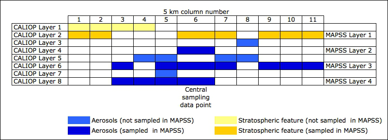
Additional information about sampled layers is indicated by the following flags:
For more information of CALIOP data usage, please refer to the CALIPSO user guide.
| MAPSS Header | Explanations | Scientific Data Set (SDS) | |
| latstart | Geodetic latitude of the laser footprint on the Earth's surface - first of the 15 pulses | Latitude | |
| latmiddle | Geodetic latitude of the laser footprint on the Earth's surface - middle of the 15 pulses | Latitude | |
| latend | Geodetic latitude of the laser footprint on the Earth's surface - last of the 15 pulses | Latitude | |
| lonstart | Longitude of the laser footprint on the Earth's surface - first of the 15 pulses | Longitude | |
| lonmiddle | Longitude of the laser footprint on the Earth's surface - middle of the 15 pulses | Longitude | |
| lonend | Longitude of the laser footprint on the Earth's surface - last of the 15 pulses | Longitude | |
| daynight | This field indicates the lighting conditions at an altitude of ~24 km above mean sea level; 0 = day, 1 = night | Day_Night_Flag | |
| offNadir | The angle, in degrees, between the viewing vector of the lidar and the nadir angle of the spacecraft | Off_Nadir_Angle | |
| solz | The angle, in degrees, between the zenith at the lidar footprint on the surface and the line of sight to the sun | Solar_Zenith_Angle | |
| sola | The azimuth angle, in degrees, from north of the line of sight to the sun | Solar_Azimuth_Angle | |
| scangle | The angle, in degrees, between the lidar viewing vector and the line of sight to the sun | Scattering_Angle | |
| reflcol0532pll | Bi-directional mean column reflectance derived from the root-mean-square (RMS) variation of the 532 nm parallel channel background measurements | Parallel_Column_Reflectance_532 | |
| uncreflcol0532pll | Not calculated for the current release; data products contain fill values in this field | Parallel_Column_Reflectance_Uncertainty_532 | |
| reflcol0532pllRMSvar | The root-mean-square (RMS) variation of the parallel channel reflectance values computed using the 15 samples that comprise a nominal 5-km horizontal swath of CALIOP lidar measurements | Parallel_Column_Reflectance_RMS_Variation_532 | |
| reflcol0532perp | Bi-directional mean column reflectance derived from the root-mean-square (RMS) variation of the 532 nm perpendicular channel background measurements | Perpendicular_Column_Reflectance_532 | |
| uncreflcol0532perp | Not calculated for the current release; data products contain fill values in this field | Perpendicular_Column_Reflectance_Uncertainty_532 | |
| reflcol0532perpRMSvar | The root-mean-square (RMS) variation of the perpendicular channel reflectance values computed using the 15 samples that comprise a nominal 5-km horizontal swath of CALIOP lidar measurements. | Perpendicular_Column_Reflectance_RMS_Variation_532 | |
| BSatt0532colint | The integral with respect to altitude of the 532 nm total attenuated backscatter coefficients. The limits of integration are from the onset of the backscatter signal at ~40-km, down to the range bin immediately prior to the surface elevation specified by the digital elevation map. | Column_Integrated_Attenuated_Backscatter_532 | |
| cprobBSatt0532colint | The cumulative probability of measuring a total column integrated attenuated backscatter value equal to the value computed for the current profile | Column_IAB_Cumulative_Probability | |
| COD0532col | Optical depth of all clouds detected within a 5 km averaged profile, obtained by integrating the 532 nm cloud extinction profile | Column_Optical_Depth_Cloud_532 | |
| uncCOD0532col | Estimated uncertainty in the Column Optical Depth Cloud 532 parameter | Column_Optical_Depth_Cloud_Uncertainty_532 | |
| AOD0532col | Optical depth of all aerosols detected within a 5 km averaged profile, obtained by integrating the 532 nm aerosol extinction profile | Column_Optical_Depth_Aerosols_532 | |
| uncAOD0532col | Estimated uncertainty in the Column Optical Depth Aerosol 532 parameter | Column_Optical_Depth_Aerosols_Uncertainty_532 | |
| SOD0532col | Optical depth of all stratospheric layers within a 5 km averaged profile, obtained by integrating the stratospheric particulate extinction coefficients reported at 532 nm | Column_Optical_Depth_Stratospheric_532 | |
| uncSOD0532col | Estimated uncertainty in the Column Optical Depth Stratospheric 532 parameter | Column_Optical_Depth_Stratospheric_Uncertainty_532 | |
| AOD1064col | Optical depth of all aerosols detected within a 5 km averaged profile, obtained by integrating the 1064 nm aerosol extinction profile | Column_Optical_Depth_Aerosols_1064 | |
| uncAOD1064col | Estimated uncertainty in the Column Optical Depth Aerosol 1064 parameter | Column_Optical_Depth_Aerosols_Uncertainty_1064 | |
| SOD1064col | Optical depth of all stratospheric layers within a 5 km averaged profile, obtained by integrating the stratospheric particulate extinction coefficients reported at 1064 nm | Column_Optical_Depth_Stratospheric_1064 | |
| uncSOD1064col | Estimated uncertainty in the Column Optical Depth Stratospheric 1064 parameter | Column_Optical_Depth_Stratospheric_Uncertainty_1064 | |
| Ffraccol | The fraction of the 5-km horizontally averaged profile, between 30-km and the DEM surface elevation, which has been identified as containing a feature (i.e., either a cloud, an aerosol, or a stratospheric layer) | Column_Feature_Fraction | |
| TropopauseHeight | Tropopause height, in kilometers above local mean sea level, derived from the GEOS-5 data product | Tropopause_Height | |
| TropopauseTemp | Tropopause temperature, in degrees C, derived from the GEOS-5 data product | Tropopause_Temperature | |
| typeSfcIGBP | International Geosphere/Biosphere Programme (IGBP) classification of the surface type at the lidar footprint. The IGBP surface types reported by CALIPSO are the same as those used in the CERES/SARB surface map. | IGBP_Surface_Type | |
| typeSfcNSIDC | Snow and ice coverage for the surface at the lidar footprint; data obtained from the National Snow and Ice Data Center (NSIDC). | NSIDC_Surface_Type | |
| ElevSfcLdrUBmin | Surface elevation at the lidar footprint, in kilometers above local mean sea level, determined by analysis of the lidar backscatter signal. Minimum of the upper boundary of the surface echo. | Lidar_Surface_Elevation | |
| ElevSfcLdrUBmax | Surface elevation at the lidar footprint, in kilometers above local mean sea level, determined by analysis of the lidar backscatter signal. Maximum of the upper boundary of the surface echo. | Lidar_Surface_Elevation | |
| ElevSfcLdrUBmean | Surface elevation at the lidar footprint, in kilometers above local mean sea level, determined by analysis of the lidar backscatter signal. Mean of the upper boundary of the surface echo. | Lidar_Surface_Elevation | |
| ElevSfcLdrUBsd | Surface elevation at the lidar footprint, in kilometers above local mean sea level, determined by analysis of the lidar backscatter signal. Standard deviation of the upper boundary of the surface echo. | Lidar_Surface_Elevation | |
| ElevSfcLdrLBmin | Surface elevation at the lidar footprint, in kilometers above local mean sea level, determined by analysis of the lidar backscatter signal. Minimum of the lower boundary of the surface echo. | Lidar_Surface_Elevation | |
| ElevSfcLdrLBmax | Surface elevation at the lidar footprint, in kilometers above local mean sea level, determined by analysis of the lidar backscatter signal. Maximum of the lower boundary of the surface echo. | Lidar_Surface_Elevation | |
| ElevSfcLdrLBmean | Surface elevation at the lidar footprint, in kilometers above local mean sea level, determined by analysis of the lidar backscatter signal. Mean of the lower boundary of the surface echo. | Lidar_Surface_Elevation | |
| ElevSfcLdrLBsd | Surface elevation at the lidar footprint, in kilometers above local mean sea level, determined by analysis of the lidar backscatter signal. Standard deviation of the lower boundary of the surface echo. | Lidar_Surface_Elevation | |
| ElevSfcDEMmin | Surface elevation at the lidar footprint, in kilometers above local mean sea level, obtained from the GTOPO30 digital elevation map (DEM) - minimum value | DEM_Surface_Elevation | |
| ElevSfcDEMmax | Surface elevation at the lidar footprint, in kilometers above local mean sea level, obtained from the GTOPO30 digital elevation map (DEM) - maximum value | DEM_Surface_Elevation | |
| ElevSfcDEMmean | Surface elevation at the lidar footprint, in kilometers above local mean sea level, obtained from the GTOPO30 digital elevation map (DEM) - median value | DEM_Surface_Elevation | |
| ElevSfcDEMsd | Surface elevation at the lidar footprint, in kilometers above local mean sea level, obtained from the GTOPO30 digital elevation map (DEM) - standard deviation of the values | DEM_Surface_Elevation | |
| dfElevSfc | A bit-mapped 8-bit integer that reports both the horizontal averaging resolution at which the surface was originally detected and, where applicable, the frequency with which the surface was subsequently detected at the 1-km averaging resolution. | Surface_Elevation_Detection_Frequency | |
| unc0532normc | Uncertainty in the 532nm calibration constant due solely to random error in the backscatter measurements in the calibration region; reported as a relative error (i.e., dC/C) in a N x 2 array | Normalization_Constant_Uncertainty | |
| unc1064normc | Uncertainty in the 1064nm calibration constant due solely to random error in the backscatter measurements in the calibration region; reported as a relative error (i.e., dC/C) in a N x 2 array | Normalization_Constant_Uncertainty | |
| altcal0532top | Top altitude, in kilometers above mean sea level, of the region of the atmosphere used for calibrating the 532nm parallel channel | Calibration_Altitude_532 | |
| altcal0532base | Base altitude, in kilometers above mean sea level, of the region of the atmosphere used for calibrating the 532nm parallel channel | Calibration_Altitude_532 | |
| QAFFinder | To generate data at a nominal 5 km horizontal resolution requires averaging 15 consecutive laser pulses. Value of 0 in a Nth bit of the 15 least significant bits of the flag indicates a feature was found for the Nth pulse. | FeatureFinderQC | |
| nLayers | The number of aerosol layers found in this column | Number_Layers_Found | |
| WSsurfzonal | Zonal surface wind speed, in meters per second, obtained from the GEOS-5 data product | Surface_Wind_Speed | |
| WSsurfmerid | Meridional surface wind speed, in meters per second, obtained from the GEOS-5 data product | Layer_Top_Altitude | |
| AltLaytop1 | Layer 1 top altitude reported in units of kilometers above mean sea level | Layer_Base_Altitude | |
| AltLaytop2 | Layer 2 top altitude reported in units of kilometers above mean sea level | Layer_Base_Altitude | |
| AltLaytop3 | Layer 3 top altitude reported in units of kilometers above mean sea level | Layer_Base_Altitude | |
| AltLaytop4 | Layer 4 top altitude reported in units of kilometers above mean sea level | Layer_Base_Altitude | |
| AltLaytop5 | Layer 5 top altitude reported in units of kilometers above mean sea level | Layer_Base_Altitude | |
| AltLaytop6 | Layer 6 top altitude reported in units of kilometers above mean sea level | Layer_Base_Altitude | |
| AltLaytop7 | Layer 7 top altitude reported in units of kilometers above mean sea level | Layer_Base_Altitude | |
| AltLaytop8 | Layer 8 top altitude reported in units of kilometers above mean sea level | Layer_Base_Altitude | |
| AltLaybase1 | Layer 1 base altitude reported in units of kilometers above mean sea level | Layer_Base_Altitude | |
| AltLaybase2 | Layer 2 base altitude reported in units of kilometers above mean sea level | Layer_Base_Altitude | |
| AltLaybase3 | Layer 3 base altitude reported in units of kilometers above mean sea level | Layer_Base_Altitude | |
| AltLaybase4 | Layer 4 base altitude reported in units of kilometers above mean sea level | Layer_Base_Altitude | |
| AltLaybase5 | Layer 5 base altitude reported in units of kilometers above mean sea level | Layer_Base_Altitude | |
| AltLaybase6 | Layer 6 base altitude reported in units of kilometers above mean sea level | Layer_Base_Altitude | |
| AltLaybase7 | Layer 7 base altitude reported in units of kilometers above mean sea level | Layer_Base_Altitude | |
| AltLaybase8 | Layer 8 base altitude reported in units of kilometers above mean sea level | Layer_Base_Altitude | |
| extendLaybase1 | A non-zero value indicates that the base of the layer 1 has been extended from the initial altitude assigned by the layer detection algorithm to a new, lower altitude lying three range bins (90 m) above the Earth's surface, and represent the layer's feature classification flags prior to the base being extended. | Layer_Base_Extended | |
| extendLaybase2 | A non-zero value indicates that the base of the layer 2 has been extended from the initial altitude assigned by the layer detection algorithm to a new, lower altitude lying three range bins (90 m) above the Earth's surface, and represent the layer's feature classification flags prior to the base being extended. | Layer_Base_Extended | |
| extendLaybase3 | A non-zero value indicates that the base of the layer 3 has been extended from the initial altitude assigned by the layer detection algorithm to a new, lower altitude lying three range bins (90 m) above the Earth's surface, and represent the layer's feature classification flags prior to the base being extended. | Layer_Base_Extended | |
| extendLaybase4 | A non-zero value indicates that the base of the layer 4 has been extended from the initial altitude assigned by the layer detection algorithm to a new, lower altitude lying three range bins (90 m) above the Earth's surface, and represent the layer's feature classification flags prior to the base being extended. | Layer_Base_Extended | |
| extendLaybase5 | A non-zero value indicates that the base of the layer 5 has been extended from the initial altitude assigned by the layer detection algorithm to a new, lower altitude lying three range bins (90 m) above the Earth's surface, and represent the layer's feature classification flags prior to the base being extended. | Layer_Base_Extended | |
| extendLaybase6 | A non-zero value indicates that the base of the layer 6 has been extended from the initial altitude assigned by the layer detection algorithm to a new, lower altitude lying three range bins (90 m) above the Earth's surface, and represent the layer's feature classification flags prior to the base being extended. | Layer_Base_Extended | |
| extendLaybase7 | A non-zero value indicates that the base of the layer 7 has been extended from the initial altitude assigned by the layer detection algorithm to a new, lower altitude lying three range bins (90 m) above the Earth's surface, and represent the layer's feature classification flags prior to the base being extended. | Layer_Base_Extended | |
| extendLaybase8 | A non-zero value indicates that the base of the layer 8 has been extended from the initial altitude assigned by the layer detection algorithm to a new, lower altitude lying three range bins (90 m) above the Earth's surface, and represent the layer's feature classification flags prior to the base being extended. | Layer_Base_Extended | |
| PressLaytop1 | Pressure, in hPa, at the layer 1 top altitude, derived from the GEOS-5 data product | Layer_Top_Pressure | |
| PressLaytop2 | Pressure, in hPa, at the layer 2 top altitude, derived from the GEOS-5 data product | Layer_Top_Pressure | |
| PressLaytop3 | Pressure, in hPa, at the layer 3 top altitude, derived from the GEOS-5 data product | Layer_Top_Pressure | |
| PressLaytop4 | Pressure, in hPa, at the layer 4 top altitude, derived from the GEOS-5 data product | Layer_Top_Pressure | |
| PressLaytop5 | Pressure, in hPa, at the layer 5 top altitude, derived from the GEOS-5 data product | Layer_Top_Pressure | |
| PressLaytop6 | Pressure, in hPa, at the layer 6 top altitude, derived from the GEOS-5 data product | Layer_Top_Pressure | |
| PressLaytop7 | Pressure, in hPa, at the layer 7 top altitude, derived from the GEOS-5 data product | Layer_Top_Pressure | |
| PressLaytop8 | Pressure, in hPa, at the layer 8 top altitude, derived from the GEOS-5 data product | Layer_Top_Pressure | |
| PressLaymid1 | Pressure, in hPa, at the geometric midpoint of the layer 1 in the vertical dimension; derived from the GEOS-5 data product | Midlayer_Pressure | |
| PressLaymid2 | Pressure, in hPa, at the geometric midpoint of the layer 2 in the vertical dimension; derived from the GEOS-5 data product | Midlayer_Pressure | |
| PressLaymid3 | Pressure, in hPa, at the geometric midpoint of the layer 3 in the vertical dimension; derived from the GEOS-5 data product | Midlayer_Pressure | |
| PressLaymid4 | Pressure, in hPa, at the geometric midpoint of the layer 4 in the vertical dimension; derived from the GEOS-5 data product | Midlayer_Pressure | |
| PressLaymid5 | Pressure, in hPa, at the geometric midpoint of the layer 5 in the vertical dimension; derived from the GEOS-5 data product | Midlayer_Pressure | |
| PressLaymid6 | Pressure, in hPa, at the geometric midpoint of the layer 6 in the vertical dimension; derived from the GEOS-5 data product | Midlayer_Pressure | |
| PressLaymid7 | Pressure, in hPa, at the geometric midpoint of the layer 7 in the vertical dimension; derived from the GEOS-5 data product | Midlayer_Pressure | |
| PressLaymid8 | Pressure, in hPa, at the geometric midpoint of the layer 8 in the vertical dimension; derived from the GEOS-5 data product | Midlayer_Pressure | |
| PressLaybase1 | Pressure, in hPa, at the layer 1 top altitude, derived from the GEOS-5 data product | Layer_Base_Pressure | |
| PressLaybase2 | Pressure, in hPa, at the layer 2 top altitude, derived from the GEOS-5 data product | Layer_Base_Pressure | |
| PressLaybase3 | Pressure, in hPa, at the layer 3 top altitude, derived from the GEOS-5 data product | Layer_Base_Pressure | |
| PressLaybase4 | Pressure, in hPa, at the layer 4 top altitude, derived from the GEOS-5 data product | Layer_Base_Pressure | |
| PressLaybase5 | Pressure, in hPa, at the layer 5 top altitude, derived from the GEOS-5 data product | Layer_Base_Pressure | |
| PressLaybase6 | Pressure, in hPa, at the layer 6 top altitude, derived from the GEOS-5 data product | Layer_Base_Pressure | |
| PressLaybase7 | Pressure, in hPa, at the layer 7 top altitude, derived from the GEOS-5 data product | Layer_Base_Pressure | |
| PressLaybase8 | Pressure, in hPa, at the layer 8 top altitude, derived from the GEOS-5 data product | Layer_Base_Pressure | |
| TempLaytop1 | Temperature, in degrees C, at the layer 1 top altitude, derived from the GEOS-5 data product | Layer_Top_Temperature | |
| TempLaytop2 | Temperature, in degrees C, at the layer 2 top altitude, derived from the GEOS-5 data product | Layer_Top_Temperature | |
| TempLaytop3 | Temperature, in degrees C, at the layer 3 top altitude, derived from the GEOS-5 data product | Layer_Top_Temperature | |
| TempLaytop4 | Temperature, in degrees C, at the layer 4 top altitude, derived from the GEOS-5 data product | Layer_Top_Temperature | |
| TempLaytop5 | Temperature, in degrees C, at the layer 5 top altitude, derived from the GEOS-5 data product | Layer_Top_Temperature | |
| TempLaytop6 | Temperature, in degrees C, at the layer 6 top altitude, derived from the GEOS-5 data product | Layer_Top_Temperature | |
| TempLaytop7 | Temperature, in degrees C, at the layer 7 top altitude, derived from the GEOS-5 data product | Layer_Top_Temperature | |
| TempLaytop8 | Temperature, in degrees C, at the layer 8 top altitude, derived from the GEOS-5 data product | Layer_Top_Temperature | |
| TempLaymid1 | Temperature, in degrees C, at the geometric midpoint of the layer 1 in the vertical dimension, derived from the GEOS-5 data product | Midlayer_Temperature | |
| TempLaymid2 | Temperature, in degrees C, at the geometric midpoint of the layer 2 in the vertical dimension, derived from the GEOS-5 data product | Midlayer_Temperature | |
| TempLaymid3 | Temperature, in degrees C, at the geometric midpoint of the layer 3 in the vertical dimension, derived from the GEOS-5 data product | Midlayer_Temperature | |
| TempLaymid4 | Temperature, in degrees C, at the geometric midpoint of the layer 4 in the vertical dimension, derived from the GEOS-5 data product | Midlayer_Temperature | |
| TempLaymid5 | Temperature, in degrees C, at the geometric midpoint of the layer 5 in the vertical dimension, derived from the GEOS-5 data product | Midlayer_Temperature | |
| TempLaymid6 | Temperature, in degrees C, at the geometric midpoint of the layer 6 in the vertical dimension, derived from the GEOS-5 data product | Midlayer_Temperature | |
| TempLaymid7 | Temperature, in degrees C, at the geometric midpoint of the layer 7 in the vertical dimension, derived from the GEOS-5 data product | Midlayer_Temperature | |
| TempLaymid8 | Temperature, in degrees C, at the geometric midpoint of the layer 8 in the vertical dimension, derived from the GEOS-5 data product | Midlayer_Temperature | |
| TempLaybase1 | Temperature, in degrees C, at the layer 1 base altitude, derived from the GEOS-5 data product | Layer_Base_Temperature | |
| TempLaybase2 | Temperature, in degrees C, at the layer 2 base altitude, derived from the GEOS-5 data product | Layer_Base_Temperature | |
| TempLaybase3 | Temperature, in degrees C, at the layer 3 base altitude, derived from the GEOS-5 data product | Layer_Base_Temperature | |
| TempLaybase4 | Temperature, in degrees C, at the layer 4 base altitude, derived from the GEOS-5 data product | Layer_Base_Temperature | |
| TempLaybase5 | Temperature, in degrees C, at the layer 5 base altitude, derived from the GEOS-5 data product | Layer_Base_Temperature | |
| TempLaybase6 | Temperature, in degrees C, at the layer 6 base altitude, derived from the GEOS-5 data product | Layer_Base_Temperature | |
| TempLaybase7 | Temperature, in degrees C, at the layer 7 base altitude, derived from the GEOS-5 data product | Layer_Base_Temperature | |
| TempLaybase8 | Temperature, in degrees C, at the layer 8 base altitude, derived from the GEOS-5 data product | Layer_Base_Temperature | |
| flagOpacity1 | An opacity flag value of 1 indicates an opaque layer 1 (i.e., layer where backscatter signal becomes completely attenuated); values of 0 indicate a transparent layer | Opacity_Flag | |
| flagOpacity2 | An opacity flag value of 1 indicates an opaque layer 2 (i.e., layer where backscatter signal becomes completely attenuated); values of 0 indicate a transparent layer | Opacity_Flag | |
| flagOpacity3 | An opacity flag value of 1 indicates an opaque layer 3 (i.e., layer where backscatter signal becomes completely attenuated); values of 0 indicate a transparent layer | Opacity_Flag | |
| flagOpacity4 | An opacity flag value of 1 indicates an opaque layer 4 (i.e., layer where backscatter signal becomes completely attenuated); values of 0 indicate a transparent layer | Opacity_Flag | |
| flagOpacity5 | An opacity flag value of 1 indicates an opaque layer 5 (i.e., layer where backscatter signal becomes completely attenuated); values of 0 indicate a transparent layer | Opacity_Flag | |
| flagOpacity6 | An opacity flag value of 1 indicates an opaque layer 6 (i.e., layer where backscatter signal becomes completely attenuated); values of 0 indicate a transparent layer | Opacity_Flag | |
| flagOpacity7 | An opacity flag value of 1 indicates an opaque layer 7 (i.e., layer where backscatter signal becomes completely attenuated); values of 0 indicate a transparent layer | Opacity_Flag | |
| flagOpacity8 | An opacity flag value of 1 indicates an opaque layer 8 (i.e., layer where backscatter signal becomes completely attenuated); values of 0 indicate a transparent layer | Opacity_Flag | |
| avHorizontal1 | The amount of horizontal averaging required for a feature to be detected at layer 1 | Horizontal_Averaging | |
| avHorizontal2 | The amount of horizontal averaging required for a feature to be detected at layer 2 | Horizontal_Averaging | |
| avHorizontal3 | The amount of horizontal averaging required for a feature to be detected at layer 3 | Horizontal_Averaging | |
| avHorizontal4 | The amount of horizontal averaging required for a feature to be detected at layer 4 | Horizontal_Averaging | |
| avHorizontal5 | The amount of horizontal averaging required for a feature to be detected at layer 5 | Horizontal_Averaging | |
| avHorizontal6 | The amount of horizontal averaging required for a feature to be detected at layer 6 | Horizontal_Averaging | |
| avHorizontal7 | The amount of horizontal averaging required for a feature to be detected at layer 7 | Horizontal_Averaging | |
| avHorizontal8 | The amount of horizontal averaging required for a feature to be detected at layer 8 | Horizontal_Averaging | |
| BSatt0532int1 | The 532nm integrated attenuated backscatter for layer 1 | Integrated_Attenuated_Backscatter_532 | |
| BSatt0532int2 | The 532nm integrated attenuated backscatter for layer 2 | Integrated_Attenuated_Backscatter_532 | |
| BSatt0532int3 | The 532nm integrated attenuated backscatter for layer 3 | Integrated_Attenuated_Backscatter_532 | |
| BSatt0532int4 | The 532nm integrated attenuated backscatter for layer 4 | Integrated_Attenuated_Backscatter_532 | |
| BSatt0532int5 | The 532nm integrated attenuated backscatter for layer 5 | Integrated_Attenuated_Backscatter_532 | |
| BSatt0532int6 | The 532nm integrated attenuated backscatter for layer 6 | Integrated_Attenuated_Backscatter_532 | |
| BSatt0532int7 | The 532nm integrated attenuated backscatter for layer 7 | Integrated_Attenuated_Backscatter_532 | |
| BSatt0532int8 | The 532nm integrated attenuated backscatter for layer 8 | Integrated_Attenuated_Backscatter_532 | |
| uncBSatt0532int1 | The uncertainties reported for the 532nm layer 1 integrated attenuated backscatters provide an estimate of the random error in the backscatter signal | Integrated_Attenuated_Backscatter_Uncertainty_532 | |
| uncBSatt0532int2 | The uncertainties reported for the 532nm layer 2 integrated attenuated backscatters provide an estimate of the random error in the backscatter signal | Integrated_Attenuated_Backscatter_Uncertainty_532 | |
| uncBSatt0532int3 | The uncertainties reported for the 532nm layer 3 integrated attenuated backscatters provide an estimate of the random error in the backscatter signal | Integrated_Attenuated_Backscatter_Uncertainty_532 | |
| uncBSatt0532int4 | The uncertainties reported for the 532nm layer 4 integrated attenuated backscatters provide an estimate of the random error in the backscatter signal | Integrated_Attenuated_Backscatter_Uncertainty_532 | |
| uncBSatt0532int5 | The uncertainties reported for the 532nm layer 5 integrated attenuated backscatters provide an estimate of the random error in the backscatter signal | Integrated_Attenuated_Backscatter_Uncertainty_532 | |
| uncBSatt0532int6 | The uncertainties reported for the 532nm layer 6 integrated attenuated backscatters provide an estimate of the random error in the backscatter signal | Integrated_Attenuated_Backscatter_Uncertainty_532 | |
| uncBSatt0532int7 | The uncertainties reported for the 532nm layer 7 integrated attenuated backscatters provide an estimate of the random error in the backscatter signal | Integrated_Attenuated_Backscatter_Uncertainty_532 | |
| uncBSatt0532int8 | The uncertainties reported for the 532nm layer 8 integrated attenuated backscatters provide an estimate of the random error in the backscatter signal | Integrated_Attenuated_Backscatter_Uncertainty_532 | |
| BSatt1064int1 | The 1064nm integrated attenuated backscatter for layer 1 | Integrated_Attenuated_Backscatter_1064 | |
| BSatt1064int2 | The 1064nm integrated attenuated backscatter for layer 2 | Integrated_Attenuated_Backscatter_1064 | |
| BSatt1064int3 | The 1064nm integrated attenuated backscatter for layer 3 | Integrated_Attenuated_Backscatter_1064 | |
| BSatt1064int4 | The 1064nm integrated attenuated backscatter for layer 4 | Integrated_Attenuated_Backscatter_1064 | |
| BSatt1064int5 | The 1064nm integrated attenuated backscatter for layer 5 | Integrated_Attenuated_Backscatter_1064 | |
| BSatt1064int6 | The 1064nm integrated attenuated backscatter for layer 6 | Integrated_Attenuated_Backscatter_1064 | |
| BSatt1064int7 | The 1064nm integrated attenuated backscatter for layer 7 | Integrated_Attenuated_Backscatter_1064 | |
| BSatt1064int8 | The 1064nm integrated attenuated backscatter for layer 8 | Integrated_Attenuated_Backscatter_1064 | |
| uncBSatt1064int1 | The uncertainties reported for the 1064nm layer 1 integrated attenuated backscatters provide an estimate of the random error in the backscatter signal | Integrated_Attenuated_Backscatter_Uncertainty_1064 | |
| uncBSatt1064int2 | The uncertainties reported for the 1064nm layer 2 integrated attenuated backscatters provide an estimate of the random error in the backscatter signal | Integrated_Attenuated_Backscatter_Uncertainty_1064 | |
| uncBSatt1064int3 | The uncertainties reported for the 1064nm layer 3 integrated attenuated backscatters provide an estimate of the random error in the backscatter signal | Integrated_Attenuated_Backscatter_Uncertainty_1064 | |
| uncBSatt1064int4 | The uncertainties reported for the 1064nm layer 4 integrated attenuated backscatters provide an estimate of the random error in the backscatter signal | Integrated_Attenuated_Backscatter_Uncertainty_1064 | |
| uncBSatt1064int5 | The uncertainties reported for the 1064nm layer 5 integrated attenuated backscatters provide an estimate of the random error in the backscatter signal | Integrated_Attenuated_Backscatter_Uncertainty_1064 | |
| uncBSatt1064int6 | The uncertainties reported for the 1064nm layer 6 integrated attenuated backscatters provide an estimate of the random error in the backscatter signal | Integrated_Attenuated_Backscatter_Uncertainty_1064 | |
| uncBSatt1064int7 | The uncertainties reported for the 1064nm layer 7 integrated attenuated backscatters provide an estimate of the random error in the backscatter signal | Integrated_Attenuated_Backscatter_Uncertainty_1064 | |
| uncBSatt1064int8 | The uncertainties reported for the 1064nm layer 8 integrated attenuated backscatters provide an estimate of the random error in the backscatter signal | Integrated_Attenuated_Backscatter_Uncertainty_1064 | |
| VDRint1 | The layer 1 integrated 532 nm volume depolarization ratio | Integrated_Volume_Depolarization_Ratio | |
| VDRint2 | The layer 2 integrated 532 nm volume depolarization ratio | Integrated_Volume_Depolarization_Ratio | |
| VDRint3 | The layer 3 integrated 532 nm volume depolarization ratio | Integrated_Volume_Depolarization_Ratio | |
| VDRint4 | The layer 4 integrated 532 nm volume depolarization ratio | Integrated_Volume_Depolarization_Ratio | |
| VDRint5 | The layer 5 integrated 532 nm volume depolarization ratio | Integrated_Volume_Depolarization_Ratio | |
| VDRint6 | The layer 6 integrated 532 nm volume depolarization ratio | Integrated_Volume_Depolarization_Ratio | |
| VDRint7 | The layer 7 integrated 532 nm volume depolarization ratio | Integrated_Volume_Depolarization_Ratio | |
| VDRint8 | The layer 8 integrated 532 nm volume depolarization ratio | Integrated_Volume_Depolarization_Ratio | |
| uncVDRint1 | The uncertainties reported for the 532 nm layer 1 integrated volume depolarization ratios provide an estimate of the total random error in the combined backscatter signals (i.e., the 532 nm parallel and perpendicular signals within the feature) | Integrated_Volume_Depolarization_Ratio_Uncertainty | |
| uncVDRint2 | The uncertainties reported for the 532 nm layer 2 integrated volume depolarization ratios provide an estimate of the total random error in the combined backscatter signals (i.e., the 532 nm parallel and perpendicular signals within the feature) | Integrated_Volume_Depolarization_Ratio_Uncertainty | |
| uncVDRint3 | The uncertainties reported for the 532 nm layer 3 integrated volume depolarization ratios provide an estimate of the total random error in the combined backscatter signals (i.e., the 532 nm parallel and perpendicular signals within the feature) | Integrated_Volume_Depolarization_Ratio_Uncertainty | |
| uncVDRint4 | The uncertainties reported for the 532 nm layer 4 integrated volume depolarization ratios provide an estimate of the total random error in the combined backscatter signals (i.e., the 532 nm parallel and perpendicular signals within the feature) | Integrated_Volume_Depolarization_Ratio_Uncertainty | |
| uncVDRint5 | The uncertainties reported for the 532 nm layer 5 integrated volume depolarization ratios provide an estimate of the total random error in the combined backscatter signals (i.e., the 532 nm parallel and perpendicular signals within the feature) | Integrated_Volume_Depolarization_Ratio_Uncertainty | |
| uncVDRint6 | The uncertainties reported for the 532 nm layer 6 integrated volume depolarization ratios provide an estimate of the total random error in the combined backscatter signals (i.e., the 532 nm parallel and perpendicular signals within the feature) | Integrated_Volume_Depolarization_Ratio_Uncertainty | |
| uncVDRint7 | The uncertainties reported for the 532 nm layer 7 integrated volume depolarization ratios provide an estimate of the total random error in the combined backscatter signals (i.e., the 532 nm parallel and perpendicular signals within the feature) | Integrated_Volume_Depolarization_Ratio_Uncertainty | |
| uncVDRint8 | The uncertainties reported for the 532 nm layer 8 integrated volume depolarization ratios provide an estimate of the total random error in the combined backscatter signals (i.e., the 532 nm parallel and perpendicular signals within the feature) | Integrated_Volume_Depolarization_Ratio_Uncertainty | |
| TCRattint1 | The layer 1 integrated attenuated total color ratio | Integrated_Attenuated_Total_Color_Ratio | |
| TCRattint2 | The layer 2 integrated attenuated total color ratio | Integrated_Attenuated_Total_Color_Ratio | |
| TCRattint3 | The layer 3 integrated attenuated total color ratio | Integrated_Attenuated_Total_Color_Ratio | |
| TCRattint4 | The layer 4 integrated attenuated total color ratio | Integrated_Attenuated_Total_Color_Ratio | |
| TCRattint5 | The layer 5 integrated attenuated total color ratio | Integrated_Attenuated_Total_Color_Ratio | |
| TCRattint6 | The layer 6 integrated attenuated total color ratio | Integrated_Attenuated_Total_Color_Ratio | |
| TCRattint7 | The layer 7 integrated attenuated total color ratio | Integrated_Attenuated_Total_Color_Ratio | |
| TCRattint8 | The layer 8 integrated attenuated total color ratio | Integrated_Attenuated_Total_Color_Ratio | |
| uncTCRattint1 | The uncertainties reported for the layer 1 integrated attenuated total color ratios provide an estimate of the total random error in the combined backscatter signals (i.e., at 532 nm and 1064 nm) | Integrated_Attenuated_Total_Color_Ratio_Uncertainty | |
| uncTCRattint2 | The uncertainties reported for the layer 2 integrated attenuated total color ratios provide an estimate of the total random error in the combined backscatter signals (i.e., at 532 nm and 1064 nm) | Integrated_Attenuated_Total_Color_Ratio_Uncertainty | |
| uncTCRattint3 | The uncertainties reported for the layer 3 integrated attenuated total color ratios provide an estimate of the total random error in the combined backscatter signals (i.e., at 532 nm and 1064 nm) | Integrated_Attenuated_Total_Color_Ratio_Uncertainty | |
| uncTCRattint4 | The uncertainties reported for the layer 4 integrated attenuated total color ratios provide an estimate of the total random error in the combined backscatter signals (i.e., at 532 nm and 1064 nm) | Integrated_Attenuated_Total_Color_Ratio_Uncertainty | |
| uncTCRattint5 | The uncertainties reported for the layer 5 integrated attenuated total color ratios provide an estimate of the total random error in the combined backscatter signals (i.e., at 532 nm and 1064 nm) | Integrated_Attenuated_Total_Color_Ratio_Uncertainty | |
| uncTCRattint6 | The uncertainties reported for the layer 6 integrated attenuated total color ratios provide an estimate of the total random error in the combined backscatter signals (i.e., at 532 nm and 1064 nm) | Integrated_Attenuated_Total_Color_Ratio_Uncertainty | |
| uncTCRattint7 | The uncertainties reported for the layer 7 integrated attenuated total color ratios provide an estimate of the total random error in the combined backscatter signals (i.e., at 532 nm and 1064 nm) | Integrated_Attenuated_Total_Color_Ratio_Uncertainty | |
| uncTCRattint8 | The uncertainties reported for the layer 8 integrated attenuated total color ratios provide an estimate of the total random error in the combined backscatter signals (i.e., at 532 nm and 1064 nm) | Integrated_Attenuated_Total_Color_Ratio_Uncertainty | |
| BSatt0532intovr1 | The overlying integrated attenuated backscatter is the integral with respect to altitude of the 532 nm total attenuated backscatter coefficients. The upper limit of integration is the first range bin in the measured signal profile, and the lower limit is the range bin immediately above the layer 1 top altitude. | Overlying_Integrated_Attenuated_Backscatter_532 | |
| BSatt0532intovr2 | The overlying integrated attenuated backscatter is the integral with respect to altitude of the 532 nm total attenuated backscatter coefficients. The upper limit of integration is the first range bin in the measured signal profile, and the lower limit is the range bin immediately above the layer 2 top altitude. | Overlying_Integrated_Attenuated_Backscatter_532 | |
| BSatt0532intovr3 | The overlying integrated attenuated backscatter is the integral with respect to altitude of the 532 nm total attenuated backscatter coefficients. The upper limit of integration is the first range bin in the measured signal profile, and the lower limit is the range bin immediately above the layer 3 top altitude. | Overlying_Integrated_Attenuated_Backscatter_532 | |
| BSatt0532intovr4 | The overlying integrated attenuated backscatter is the integral with respect to altitude of the 532 nm total attenuated backscatter coefficients. The upper limit of integration is the first range bin in the measured signal profile, and the lower limit is the range bin immediately above the layer 4 top altitude. | Overlying_Integrated_Attenuated_Backscatter_532 | |
| BSatt0532intovr5 | The overlying integrated attenuated backscatter is the integral with respect to altitude of the 532 nm total attenuated backscatter coefficients. The upper limit of integration is the first range bin in the measured signal profile, and the lower limit is the range bin immediately above the layer 5 top altitude. | Overlying_Integrated_Attenuated_Backscatter_532 | |
| BSatt0532intovr6 | The overlying integrated attenuated backscatter is the integral with respect to altitude of the 532 nm total attenuated backscatter coefficients. The upper limit of integration is the first range bin in the measured signal profile, and the lower limit is the range bin immediately above the layer 6 top altitude. | Overlying_Integrated_Attenuated_Backscatter_532 | |
| BSatt0532intovr7 | The overlying integrated attenuated backscatter is the integral with respect to altitude of the 532 nm total attenuated backscatter coefficients. The upper limit of integration is the first range bin in the measured signal profile, and the lower limit is the range bin immediately above the layer 7 top altitude. | Overlying_Integrated_Attenuated_Backscatter_532 | |
| BSatt0532intovr8 | The overlying integrated attenuated backscatter is the integral with respect to altitude of the 532 nm total attenuated backscatter coefficients. The upper limit of integration is the first range bin in the measured signal profile, and the lower limit is the range bin immediately above the layer 8 top altitude. | Overlying_Integrated_Attenuated_Backscatter_532 | |
| QAlayIABfctr1 | Defined as 1-F(overlying integrated attenuated backscatter), where F(overlying integrated attenuated backscatter) is the cumulative probability of measuring a complete column integrated attenuated backscatter equal to the value of the overlying integrated attenuated backscatter for layer 1 | Layer_IAB_QA_Factor | |
| QAlayIABfctr2 | Defined as 1-F(overlying integrated attenuated backscatter), where F(overlying integrated attenuated backscatter) is the cumulative probability of measuring a complete column integrated attenuated backscatter equal to the value of the overlying integrated attenuated backscatter for layer 2 | Layer_IAB_QA_Factor | |
| QAlayIABfctr3 | Defined as 1-F(overlying integrated attenuated backscatter), where F(overlying integrated attenuated backscatter) is the cumulative probability of measuring a complete column integrated attenuated backscatter equal to the value of the overlying integrated attenuated backscatter for layer 3 | Layer_IAB_QA_Factor | |
| QAlayIABfctr4 | Defined as 1-F(overlying integrated attenuated backscatter), where F(overlying integrated attenuated backscatter) is the cumulative probability of measuring a complete column integrated attenuated backscatter equal to the value of the overlying integrated attenuated backscatter for layer 4 | Layer_IAB_QA_Factor | |
| QAlayIABfctr5 | Defined as 1-F(overlying integrated attenuated backscatter), where F(overlying integrated attenuated backscatter) is the cumulative probability of measuring a complete column integrated attenuated backscatter equal to the value of the overlying integrated attenuated backscatter for layer 5 | Layer_IAB_QA_Factor | |
| QAlayIABfctr6 | Defined as 1-F(overlying integrated attenuated backscatter), where F(overlying integrated attenuated backscatter) is the cumulative probability of measuring a complete column integrated attenuated backscatter equal to the value of the overlying integrated attenuated backscatter for layer 6 | Layer_IAB_QA_Factor | |
| QAlayIABfctr7 | Defined as 1-F(overlying integrated attenuated backscatter), where F(overlying integrated attenuated backscatter) is the cumulative probability of measuring a complete column integrated attenuated backscatter equal to the value of the overlying integrated attenuated backscatter for layer 7 | Layer_IAB_QA_Factor | |
| QAlayIABfctr8 | Defined as 1-F(overlying integrated attenuated backscatter), where F(overlying integrated attenuated backscatter) is the cumulative probability of measuring a complete column integrated attenuated backscatter equal to the value of the overlying integrated attenuated backscatter for layer 8 | Layer_IAB_QA_Factor | |
| FlagFclass1 | The 16-bit bit-mapped flags report feature type, subtype, amount of horizontal averaging required for layer detection, and quality of classifications for layer 1 | Feature_Classification_Flags | |
| FlagFclass2 | The 16-bit bit-mapped flags report feature type, subtype, amount of horizontal averaging required for layer detection, and quality of classifications for layer 2 | Feature_Classification_Flags | |
| FlagFclass3 | The 16-bit bit-mapped flags report feature type, subtype, amount of horizontal averaging required for layer detection, and quality of classifications for layer 3 | Feature_Classification_Flags | |
| FlagFclass4 | The 16-bit bit-mapped flags report feature type, subtype, amount of horizontal averaging required for layer detection, and quality of classifications for layer 4 | Feature_Classification_Flags | |
| FlagFclass5 | The 16-bit bit-mapped flags report feature type, subtype, amount of horizontal averaging required for layer detection, and quality of classifications for layer 5 | Feature_Classification_Flags | |
| FlagFclass6 | The 16-bit bit-mapped flags report feature type, subtype, amount of horizontal averaging required for layer detection, and quality of classifications for layer 6 | Feature_Classification_Flags | |
| FlagFclass7 | The 16-bit bit-mapped flags report feature type, subtype, amount of horizontal averaging required for layer detection, and quality of classifications for layer 7 | Feature_Classification_Flags | |
| FlagFclass8 | The 16-bit bit-mapped flags report feature type, subtype, amount of horizontal averaging required for layer detection, and quality of classifications for layer 8 | Feature_Classification_Flags | |
| QA0532ext1 | The 16-bit bit-mapped flags report various characteristics of the retrieval at 532nm (e.g., constrained, no solution, etc.) for layer 1 | ExtinctionQC_532 | |
| QA0532ext2 | The 16-bit bit-mapped flags report various characteristics of the retrieval at 532nm (e.g., constrained, no solution, etc.) for layer 2 | ExtinctionQC_532 | |
| QA0532ext3 | The 16-bit bit-mapped flags report various characteristics of the retrieval at 532nm (e.g., constrained, no solution, etc.) for layer 3 | ExtinctionQC_532 | |
| QA0532ext4 | The 16-bit bit-mapped flags report various characteristics of the retrieval at 532nm (e.g., constrained, no solution, etc.) for layer 4 | ExtinctionQC_532 | |
| QA0532ext5 | The 16-bit bit-mapped flags report various characteristics of the retrieval at 532nm (e.g., constrained, no solution, etc.) for layer 5 | ExtinctionQC_532 | |
| QA0532ext6 | The 16-bit bit-mapped flags report various characteristics of the retrieval at 532nm (e.g., constrained, no solution, etc.) for layer 6 | ExtinctionQC_532 | |
| QA0532ext7 | The 16-bit bit-mapped flags report various characteristics of the retrieval at 532nm (e.g., constrained, no solution, etc.) for layer 7 | ExtinctionQC_532 | |
| QA0532ext8 | The 16-bit bit-mapped flags report various characteristics of the retrieval at 532nm (e.g., constrained, no solution, etc.) for layer 8 | ExtinctionQC_532 | |
| QA1064ext1 | The 16-bit bit-mapped flags report various characteristics of the retrieval at 1064nm (e.g., constrained, no solution, etc.) for layer 1 | ExtinctionQC_1064 | |
| QA1064ext2 | The 16-bit bit-mapped flags report various characteristics of the retrieval at 1064nm (e.g., constrained, no solution, etc.) for layer 2 | ExtinctionQC_1064 | |
| QA1064ext3 | The 16-bit bit-mapped flags report various characteristics of the retrieval at 1064nm (e.g., constrained, no solution, etc.) for layer 3 | ExtinctionQC_1064 | |
| QA1064ext4 | The 16-bit bit-mapped flags report various characteristics of the retrieval at 1064nm (e.g., constrained, no solution, etc.) for layer 4 | ExtinctionQC_1064 | |
| QA1064ext5 | The 16-bit bit-mapped flags report various characteristics of the retrieval at 1064nm (e.g., constrained, no solution, etc.) for layer 5 | ExtinctionQC_1064 | |
| QA1064ext6 | The 16-bit bit-mapped flags report various characteristics of the retrieval at 1064nm (e.g., constrained, no solution, etc.) for layer 6 | ExtinctionQC_1064 | |
| QA1064ext7 | The 16-bit bit-mapped flags report various characteristics of the retrieval at 1064nm (e.g., constrained, no solution, etc.) for layer 7 | ExtinctionQC_1064 | |
| QA1064ext8 | The 16-bit bit-mapped flags report various characteristics of the retrieval at 1064nm (e.g., constrained, no solution, etc.) for layer 8 | ExtinctionQC_1064 | |
| CADscore1 | The cloud-aerosol discrimination (CAD) score that provides a numerical confidence level for the classification of layer 1 by the CALIOP cloud-aerosol discrimination algorithm. 100 indicates complete confidence for clouds, -100 indicates complete confidence for aerosols. Values outside of [-100,100] are special indicators. | CAD_Score | |
| CADscore2 | The cloud-aerosol discrimination (CAD) score that provides a numerical confidence level for the classification of layer 2 by the CALIOP cloud-aerosol discrimination algorithm. 100 indicates complete confidence for clouds, -100 indicates complete confidence for aerosols. Values outside of [-100,100] are special indicators. | CAD_Score | |
| CADscore3 | The cloud-aerosol discrimination (CAD) score that provides a numerical confidence level for the classification of layer 3 by the CALIOP cloud-aerosol discrimination algorithm. 100 indicates complete confidence for clouds, -100 indicates complete confidence for aerosols. Values outside of [-100,100] are special indicators. | CAD_Score | |
| CADscore4 | The cloud-aerosol discrimination (CAD) score that provides a numerical confidence level for the classification of layer 4 by the CALIOP cloud-aerosol discrimination algorithm. 100 indicates complete confidence for clouds, -100 indicates complete confidence for aerosols. Values outside of [-100,100] are special indicators. | CAD_Score | |
| CADscore5 | The cloud-aerosol discrimination (CAD) score that provides a numerical confidence level for the classification of layer 5 by the CALIOP cloud-aerosol discrimination algorithm. 100 indicates complete confidence for clouds, -100 indicates complete confidence for aerosols. Values outside of [-100,100] are special indicators. | CAD_Score | |
| CADscore6 | The cloud-aerosol discrimination (CAD) score that provides a numerical confidence level for the classification of layer 6 by the CALIOP cloud-aerosol discrimination algorithm. 100 indicates complete confidence for clouds, -100 indicates complete confidence for aerosols. Values outside of [-100,100] are special indicators. | CAD_Score | |
| CADscore7 | The cloud-aerosol discrimination (CAD) score that provides a numerical confidence level for the classification of layer 7 by the CALIOP cloud-aerosol discrimination algorithm. 100 indicates complete confidence for clouds, -100 indicates complete confidence for aerosols. Values outside of [-100,100] are special indicators. | CAD_Score | |
| CADscore8 | The cloud-aerosol discrimination (CAD) score that provides a numerical confidence level for the classification of layer 8 by the CALIOP cloud-aerosol discrimination algorithm. 100 indicates complete confidence for clouds, -100 indicates complete confidence for aerosols. Values outside of [-100,100] are special indicators. | CAD_Score | |
| Ttwoway0532meas1 | The measured value of the layer 1 two-way transmittance (T^2) for isolated (i.e., not in contact with other layers or surface) transparent layers | Measured_Two_Way_Transmittance_532 | |
| Ttwoway0532meas2 | The measured value of the layer 2 two-way transmittance (T^2) for isolated (i.e., not in contact with other layers or surface) transparent layers | Measured_Two_Way_Transmittance_532 | |
| Ttwoway0532meas3 | The measured value of the layer 3 two-way transmittance (T^2) for isolated (i.e., not in contact with other layers or surface) transparent layers | Measured_Two_Way_Transmittance_532 | |
| Ttwoway0532meas4 | The measured value of the layer 4 two-way transmittance (T^2) for isolated (i.e., not in contact with other layers or surface) transparent layers | Measured_Two_Way_Transmittance_532 | |
| Ttwoway0532meas5 | The measured value of the layer 5 two-way transmittance (T^2) for isolated (i.e., not in contact with other layers or surface) transparent layers | Measured_Two_Way_Transmittance_532 | |
| Ttwoway0532meas6 | The measured value of the layer 6 two-way transmittance (T^2) for isolated (i.e., not in contact with other layers or surface) transparent layers | Measured_Two_Way_Transmittance_532 | |
| Ttwoway0532meas7 | The measured value of the layer 7 two-way transmittance (T^2) for isolated (i.e., not in contact with other layers or surface) transparent layers | Measured_Two_Way_Transmittance_532 | |
| Ttwoway0532meas8 | The measured value of the layer 8 two-way transmittance (T^2) for isolated (i.e., not in contact with other layers or surface) transparent layers | Measured_Two_Way_Transmittance_532 | |
| uncTtwoway0532meas1 | The relative error in the two-way transmittance measurement for layer 1, calculated using standard techniques for error propagation in rationed quantities | Measured_Two_Way_Transmittance_Uncertainty_532 | |
| uncTtwoway0532meas2 | The relative error in the two-way transmittance measurement for layer 2, calculated using standard techniques for error propagation in rationed quantities | Measured_Two_Way_Transmittance_Uncertainty_532 | |
| uncTtwoway0532meas3 | The relative error in the two-way transmittance measurement for layer 3, calculated using standard techniques for error propagation in rationed quantities | Measured_Two_Way_Transmittance_Uncertainty_532 | |
| uncTtwoway0532meas4 | The relative error in the two-way transmittance measurement for layer 4, calculated using standard techniques for error propagation in rationed quantities | Measured_Two_Way_Transmittance_Uncertainty_532 | |
| uncTtwoway0532meas5 | The relative error in the two-way transmittance measurement for layer 5, calculated using standard techniques for error propagation in rationed quantities | Measured_Two_Way_Transmittance_Uncertainty_532 | |
| uncTtwoway0532meas6 | The relative error in the two-way transmittance measurement for layer 6, calculated using standard techniques for error propagation in rationed quantities | Measured_Two_Way_Transmittance_Uncertainty_532 | |
| uncTtwoway0532meas7 | The relative error in the two-way transmittance measurement for layer 7, calculated using standard techniques for error propagation in rationed quantities | Measured_Two_Way_Transmittance_Uncertainty_532 | |
| uncTtwoway0532meas8 | The relative error in the two-way transmittance measurement for layer 8, calculated using standard techniques for error propagation in rationed quantities | Measured_Two_Way_Transmittance_Uncertainty_532 | |
| rgnTtwoway0532meas1up | Specifies the upper boundary for the "clear air" altitude region beneath layer 1; the mean attenuated scattering ratio that determines the layer two-way transmittance is calculated using this region | Two_Way_Transmittance_Measurement_Region | |
| rgnTtwoway0532meas2up | Specifies the upper boundary for the "clear air" altitude region beneath layer 2; the mean attenuated scattering ratio that determines the layer two-way transmittance is calculated using this region | Two_Way_Transmittance_Measurement_Region | |
| rgnTtwoway0532meas3up | Specifies the upper boundary for the "clear air" altitude region beneath layer 3; the mean attenuated scattering ratio that determines the layer two-way transmittance is calculated using this region | Two_Way_Transmittance_Measurement_Region | |
| rgnTtwoway0532meas4up | Specifies the upper boundary for the "clear air" altitude region beneath layer 4; the mean attenuated scattering ratio that determines the layer two-way transmittance is calculated using this region | Two_Way_Transmittance_Measurement_Region | |
| rgnTtwoway0532meas5up | Specifies the upper boundary for the "clear air" altitude region beneath layer 5; the mean attenuated scattering ratio that determines the layer two-way transmittance is calculated using this region | Two_Way_Transmittance_Measurement_Region | |
| rgnTtwoway0532meas6up | Specifies the upper boundary for the "clear air" altitude region beneath layer 6; the mean attenuated scattering ratio that determines the layer two-way transmittance is calculated using this region | Two_Way_Transmittance_Measurement_Region | |
| rgnTtwoway0532meas7up | Specifies the upper boundary for the "clear air" altitude region beneath layer 7; the mean attenuated scattering ratio that determines the layer two-way transmittance is calculated using this region | Two_Way_Transmittance_Measurement_Region | |
| rgnTtwoway0532meas8up | Specifies the upper boundary for the "clear air" altitude region beneath layer 8; the mean attenuated scattering ratio that determines the layer two-way transmittance is calculated using this region | Two_Way_Transmittance_Measurement_Region | |
| rgnTtwoway0532meas1lw | Specifies the lower boundary for the "clear air" altitude region beneath layer 1; the mean attenuated scattering ratio that determines the layer two-way transmittance is calculated using this region | Two_Way_Transmittance_Measurement_Region | |
| rgnTtwoway0532meas2lw | Specifies the lower boundary for the "clear air" altitude region beneath layer 2; the mean attenuated scattering ratio that determines the layer two-way transmittance is calculated using this region | Two_Way_Transmittance_Measurement_Region | |
| rgnTtwoway0532meas3lw | Specifies the lower boundary for the "clear air" altitude region beneath layer 3; the mean attenuated scattering ratio that determines the layer two-way transmittance is calculated using this region | Two_Way_Transmittance_Measurement_Region | |
| rgnTtwoway0532meas4lw | Specifies the lower boundary for the "clear air" altitude region beneath layer 4; the mean attenuated scattering ratio that determines the layer two-way transmittance is calculated using this region | Two_Way_Transmittance_Measurement_Region | |
| rgnTtwoway0532meas5lw | Specifies the lower boundary for the "clear air" altitude region beneath layer 5; the mean attenuated scattering ratio that determines the layer two-way transmittance is calculated using this region | Two_Way_Transmittance_Measurement_Region | |
| rgnTtwoway0532meas6lw | Specifies the lower boundary for the "clear air" altitude region beneath layer 6; the mean attenuated scattering ratio that determines the layer two-way transmittance is calculated using this region | Two_Way_Transmittance_Measurement_Region | |
| rgnTtwoway0532meas7lw | Specifies the lower boundary for the "clear air" altitude region beneath layer 7; the mean attenuated scattering ratio that determines the layer two-way transmittance is calculated using this region | Two_Way_Transmittance_Measurement_Region | |
| rgnTtwoway0532meas8lw | Specifies the lower boundary for the "clear air" altitude region beneath layer 8; the mean attenuated scattering ratio that determines the layer two-way transmittance is calculated using this region | Two_Way_Transmittance_Measurement_Region | |
| FOD0532_1 | Reports estimates of layer 1 (i.e., aerosol or stratospheric feature) optical depth at 532nm | Feature_Optical_Depth_532 | |
| FOD0532_2 | Reports estimates of layer 2 (i.e., aerosol or stratospheric feature) optical depth at 532nm | Feature_Optical_Depth_532 | |
| FOD0532_3 | Reports estimates of layer 3 (i.e., aerosol or stratospheric feature) optical depth at 532nm | Feature_Optical_Depth_532 | |
| FOD0532_4 | Reports estimates of layer 4 (i.e., aerosol or stratospheric feature) optical depth at 532nm | Feature_Optical_Depth_532 | |
| FOD0532_5 | Reports estimates of layer 5 (i.e., aerosol or stratospheric feature) optical depth at 532nm | Feature_Optical_Depth_532 | |
| FOD0532_6 | Reports estimates of layer 6 (i.e., aerosol or stratospheric feature) optical depth at 532nm | Feature_Optical_Depth_532 | |
| FOD0532_7 | Reports estimates of layer 7 (i.e., aerosol or stratospheric feature) optical depth at 532nm | Feature_Optical_Depth_532 | |
| FOD0532_8 | Reports estimates of layer 8 (i.e., aerosol or stratospheric feature) optical depth at 532nm | Feature_Optical_Depth_532 | |
| uncFOD0532_1 | Estimated uncertainty in the layer 1 optical depth at 532nm | Feature_Optical_Depth_Uncertainty_532 | |
| uncFOD0532_2 | Estimated uncertainty in the layer 2 optical depth at 532nm | Feature_Optical_Depth_Uncertainty_532 | |
| uncFOD0532_3 | Estimated uncertainty in the layer 3 optical depth at 532nm | Feature_Optical_Depth_Uncertainty_532 | |
| uncFOD0532_4 | Estimated uncertainty in the layer 4 optical depth at 532nm | Feature_Optical_Depth_Uncertainty_532 | |
| uncFOD0532_5 | Estimated uncertainty in the layer 5 optical depth at 532nm | Feature_Optical_Depth_Uncertainty_532 | |
| uncFOD0532_6 | Estimated uncertainty in the layer 6 optical depth at 532nm | Feature_Optical_Depth_Uncertainty_532 | |
| uncFOD0532_7 | Estimated uncertainty in the layer 7 optical depth at 532nm | Feature_Optical_Depth_Uncertainty_532 | |
| uncFOD0532_8 | Estimated uncertainty in the layer 8 optical depth at 532nm | Feature_Optical_Depth_Uncertainty_532 | |
| LR0532ini1 | Initial estimate of the lidar ratio for layer 1 before the extinction processing at 532nm | Initial_532_Lidar_Ratio | |
| LR0532ini2 | Initial estimate of the lidar ratio for layer 2 before the extinction processing at 532nm | Initial_532_Lidar_Ratio | |
| LR0532ini3 | Initial estimate of the lidar ratio for layer 3 before the extinction processing at 532nm | Initial_532_Lidar_Ratio | |
| LR0532ini4 | Initial estimate of the lidar ratio for layer 4 before the extinction processing at 532nm | Initial_532_Lidar_Ratio | |
| LR0532ini5 | Initial estimate of the lidar ratio for layer 5 before the extinction processing at 532nm | Initial_532_Lidar_Ratio | |
| LR0532ini6 | Initial estimate of the lidar ratio for layer 6 before the extinction processing at 532nm | Initial_532_Lidar_Ratio | |
| LR0532ini7 | Initial estimate of the lidar ratio for layer 7 before the extinction processing at 532nm | Initial_532_Lidar_Ratio | |
| LR0532ini8 | Initial estimate of the lidar ratio for layer 8 before the extinction processing at 532nm | Initial_532_Lidar_Ratio | |
| LR0532fin1 | Lidar ratio in use at the conclusion of the extinction processing for layer 1 at 532nm | Final_532_Lidar_Ratio | |
| LR0532fin2 | Lidar ratio in use at the conclusion of the extinction processing for layer 2 at 532nm | Final_532_Lidar_Ratio | |
| LR0532fin3 | Lidar ratio in use at the conclusion of the extinction processing for layer 3 at 532nm | Final_532_Lidar_Ratio | |
| LR0532fin4 | Lidar ratio in use at the conclusion of the extinction processing for layer 4 at 532nm | Final_532_Lidar_Ratio | |
| LR0532fin5 | Lidar ratio in use at the conclusion of the extinction processing for layer 5 at 532nm | Final_532_Lidar_Ratio | |
| LR0532fin6 | Lidar ratio in use at the conclusion of the extinction processing for layer 6 at 532nm | Final_532_Lidar_Ratio | |
| LR0532fin7 | Lidar ratio in use at the conclusion of the extinction processing for layer 7 at 532nm | Final_532_Lidar_Ratio | |
| LR0532fin8 | Lidar ratio in use at the conclusion of the extinction processing for layer 8 at 532nm | Final_532_Lidar_Ratio | |
| smethodLR0532_1 | Flag specifying the internal procedure used to select the initial lidar ratio for layer 1 at 532nm | Lidar_Ratio_532_Selection_Method | |
| smethodLR0532_2 | Flag specifying the internal procedure used to select the initial lidar ratio for layer 2 at 532nm | Lidar_Ratio_532_Selection_Method | |
| smethodLR0532_3 | Flag specifying the internal procedure used to select the initial lidar ratio for layer 3 at 532nm | Lidar_Ratio_532_Selection_Method | |
| smethodLR0532_4 | Flag specifying the internal procedure used to select the initial lidar ratio for layer 4 at 532nm | Lidar_Ratio_532_Selection_Method | |
| smethodLR0532_5 | Flag specifying the internal procedure used to select the initial lidar ratio for layer 5 at 532nm | Lidar_Ratio_532_Selection_Method | |
| smethodLR0532_6 | Flag specifying the internal procedure used to select the initial lidar ratio for layer 6 at 532nm | Lidar_Ratio_532_Selection_Method | |
| smethodLR0532_7 | Flag specifying the internal procedure used to select the initial lidar ratio for layer 7 at 532nm | Lidar_Ratio_532_Selection_Method | |
| smethodLR0532_8 | Flag specifying the internal procedure used to select the initial lidar ratio for layer 8 at 532nm | Lidar_Ratio_532_Selection_Method | |
| MSFlay0532eff1 | The layer 1 effective multiple scattering factors are the values range between 0 and 1; 1 corresponds to the limit of single scattering only; smaller values indicate increasing contributions to the backscatter signal from multiple scattering at 532nm | Layer_Effective_532_Multiple_Scattering_Factor | |
| MSFlay0532eff2 | The layer 2 effective multiple scattering factors are the values range between 0 and 1; 1 corresponds to the limit of single scattering only; smaller values indicate increasing contributions to the backscatter signal from multiple scattering at 532nm | Layer_Effective_532_Multiple_Scattering_Factor | |
| MSFlay0532eff3 | The layer 3 effective multiple scattering factors are the values range between 0 and 1; 1 corresponds to the limit of single scattering only; smaller values indicate increasing contributions to the backscatter signal from multiple scattering at 532nm | Layer_Effective_532_Multiple_Scattering_Factor | |
| MSFlay0532eff4 | The layer 4 effective multiple scattering factors are the values range between 0 and 1; 1 corresponds to the limit of single scattering only; smaller values indicate increasing contributions to the backscatter signal from multiple scattering at 532nm | Layer_Effective_532_Multiple_Scattering_Factor | |
| MSFlay0532eff5 | The layer 5 effective multiple scattering factors are the values range between 0 and 1; 1 corresponds to the limit of single scattering only; smaller values indicate increasing contributions to the backscatter signal from multiple scattering at 532nm | Layer_Effective_532_Multiple_Scattering_Factor | |
| MSFlay0532eff6 | The layer 6 effective multiple scattering factors are the values range between 0 and 1; 1 corresponds to the limit of single scattering only; smaller values indicate increasing contributions to the backscatter signal from multiple scattering at 532nm | Layer_Effective_532_Multiple_Scattering_Factor | |
| MSFlay0532eff7 | The layer 7 effective multiple scattering factors are the values range between 0 and 1; 1 corresponds to the limit of single scattering only; smaller values indicate increasing contributions to the backscatter signal from multiple scattering at 532nm | Layer_Effective_532_Multiple_Scattering_Factor | |
| MSFlay0532eff8 | The layer 8 effective multiple scattering factors are the values range between 0 and 1; 1 corresponds to the limit of single scattering only; smaller values indicate increasing contributions to the backscatter signal from multiple scattering at 532nm | Layer_Effective_532_Multiple_Scattering_Factor | |
| PDRint1 | The particulate depolarization ratio represents the contribution to the volume depolarization ratio that is due only to the cloud and/or aerosol particles within the layer 1 | Integrated_Particulate_Depolarization_Ratio | |
| PDRint2 | The particulate depolarization ratio represents the contribution to the volume depolarization ratio that is due only to the cloud and/or aerosol particles within the layer 2 | Integrated_Particulate_Depolarization_Ratio | |
| PDRint3 | The particulate depolarization ratio represents the contribution to the volume depolarization ratio that is due only to the cloud and/or aerosol particles within the layer 3 | Integrated_Particulate_Depolarization_Ratio | |
| PDRint4 | The particulate depolarization ratio represents the contribution to the volume depolarization ratio that is due only to the cloud and/or aerosol particles within the layer 4 | Integrated_Particulate_Depolarization_Ratio | |
| PDRint5 | The particulate depolarization ratio represents the contribution to the volume depolarization ratio that is due only to the cloud and/or aerosol particles within the layer 5 | Integrated_Particulate_Depolarization_Ratio | |
| PDRint6 | The particulate depolarization ratio represents the contribution to the volume depolarization ratio that is due only to the cloud and/or aerosol particles within the layer 6 | Integrated_Particulate_Depolarization_Ratio | |
| PDRint7 | The particulate depolarization ratio represents the contribution to the volume depolarization ratio that is due only to the cloud and/or aerosol particles within the layer 7 | Integrated_Particulate_Depolarization_Ratio | |
| PDRint8 | The particulate depolarization ratio represents the contribution to the volume depolarization ratio that is due only to the cloud and/or aerosol particles within the layer 8 | Integrated_Particulate_Depolarization_Ratio | |
| uncPDRint1 | Uncertainty associated with the estimate of the layer 1 integrated particulate depolarization ratio | Integrated_Particulate_Depolarization_Ratio_Uncertainty | |
| uncPDRint2 | Uncertainty associated with the estimate of the layer 2 integrated particulate depolarization ratio | Integrated_Particulate_Depolarization_Ratio_Uncertainty | |
| uncPDRint3 | Uncertainty associated with the estimate of the layer 3 integrated particulate depolarization ratio | Integrated_Particulate_Depolarization_Ratio_Uncertainty | |
| uncPDRint4 | Uncertainty associated with the estimate of the layer 4 integrated particulate depolarization ratio | Integrated_Particulate_Depolarization_Ratio_Uncertainty | |
| uncPDRint5 | Uncertainty associated with the estimate of the layer 5 integrated particulate depolarization ratio | Integrated_Particulate_Depolarization_Ratio_Uncertainty | |
| uncPDRint6 | Uncertainty associated with the estimate of the layer 6 integrated particulate depolarization ratio | Integrated_Particulate_Depolarization_Ratio_Uncertainty | |
| uncPDRint7 | Uncertainty associated with the estimate of the layer 7 integrated particulate depolarization ratio | Integrated_Particulate_Depolarization_Ratio_Uncertainty | |
| uncPDRint8 | Uncertainty associated with the estimate of the layer 8 integrated particulate depolarization ratio | Integrated_Particulate_Depolarization_Ratio_Uncertainty | |
| FOD1064_1 | Reports estimates of layer 1 (i.e., aerosol or stratospheric feature) optical depth at 1064nm | Feature_Optical_Depth_1064 | |
| FOD1064_2 | Reports estimates of layer 2 (i.e., aerosol or stratospheric feature) optical depth at 1064nm | Feature_Optical_Depth_1064 | |
| FOD1064_3 | Reports estimates of layer 3 (i.e., aerosol or stratospheric feature) optical depth at 1064nm | Feature_Optical_Depth_1064 | |
| FOD1064_4 | Reports estimates of layer 4 (i.e., aerosol or stratospheric feature) optical depth at 1064nm | Feature_Optical_Depth_1064 | |
| FOD1064_5 | Reports estimates of layer 5 (i.e., aerosol or stratospheric feature) optical depth at 1064nm | Feature_Optical_Depth_1064 | |
| FOD1064_6 | Reports estimates of layer 6 (i.e., aerosol or stratospheric feature) optical depth at 1064nm | Feature_Optical_Depth_1064 | |
| FOD1064_7 | Reports estimates of layer 7 (i.e., aerosol or stratospheric feature) optical depth at 1064nm | Feature_Optical_Depth_1064 | |
| FOD1064_8 | Reports estimates of layer 8 (i.e., aerosol or stratospheric feature) optical depth at 1064nm | Feature_Optical_Depth_1064 | |
| uncFOD1064_1 | Estimated uncertainty in the layer 1 optical depth at 1064nm | Feature_Optical_Depth_Uncertainty_1064 | |
| uncFOD1064_2 | Estimated uncertainty in the layer 2 optical depth at 1064nm | Feature_Optical_Depth_Uncertainty_1064 | |
| uncFOD1064_3 | Estimated uncertainty in the layer 3 optical depth at 1064nm | Feature_Optical_Depth_Uncertainty_1064 | |
| uncFOD1064_4 | Estimated uncertainty in the layer 4 optical depth at 1064nm | Feature_Optical_Depth_Uncertainty_1064 | |
| uncFOD1064_5 | Estimated uncertainty in the layer 5 optical depth at 1064nm | Feature_Optical_Depth_Uncertainty_1064 | |
| uncFOD1064_6 | Estimated uncertainty in the layer 6 optical depth at 1064nm | Feature_Optical_Depth_Uncertainty_1064 | |
| uncFOD1064_7 | Estimated uncertainty in the layer 7 optical depth at 1064nm | Feature_Optical_Depth_Uncertainty_1064 | |
| uncFOD1064_8 | Estimated uncertainty in the layer 8 optical depth at 1064nm | Feature_Optical_Depth_Uncertainty_1064 | |
| LR1064ini1 | Layer 1 initial estimate of the lidar ratio before the extinction processing at 1064nm | Initial_1064_Lidar_Ratio | |
| LR1064ini2 | Layer 2 initial estimate of the lidar ratio before the extinction processing at 1064nm | Initial_1064_Lidar_Ratio | |
| LR1064ini3 | Layer 3 initial estimate of the lidar ratio before the extinction processing at 1064nm | Initial_1064_Lidar_Ratio | |
| LR1064ini4 | Layer 4 initial estimate of the lidar ratio before the extinction processing at 1064nm | Initial_1064_Lidar_Ratio | |
| LR1064ini5 | Layer 5 initial estimate of the lidar ratio before the extinction processing at 1064nm | Initial_1064_Lidar_Ratio | |
| LR1064ini6 | Layer 6 initial estimate of the lidar ratio before the extinction processing at 1064nm | Initial_1064_Lidar_Ratio | |
| LR1064ini7 | Layer 7 initial estimate of the lidar ratio before the extinction processing at 1064nm | Initial_1064_Lidar_Ratio | |
| LR1064ini8 | Layer 8 initial estimate of the lidar ratio before the extinction processing at 1064nm | Initial_1064_Lidar_Ratio | |
| LR1064fin1 | Lidar ratio in use at the conclusion of the extinction processing for layer 1 at 1064nm | Final_1064_Lidar_Ratio | |
| LR1064fin2 | Lidar ratio in use at the conclusion of the extinction processing for layer 2 at 1064nm | Final_1064_Lidar_Ratio | |
| LR1064fin3 | Lidar ratio in use at the conclusion of the extinction processing for layer 3 at 1064nm | Final_1064_Lidar_Ratio | |
| LR1064fin4 | Lidar ratio in use at the conclusion of the extinction processing for layer 4 at 1064nm | Final_1064_Lidar_Ratio | |
| LR1064fin5 | Lidar ratio in use at the conclusion of the extinction processing for layer 5 at 1064nm | Final_1064_Lidar_Ratio | |
| LR1064fin6 | Lidar ratio in use at the conclusion of the extinction processing for layer 6 at 1064nm | Final_1064_Lidar_Ratio | |
| LR1064fin7 | Lidar ratio in use at the conclusion of the extinction processing for layer 7 at 1064nm | Final_1064_Lidar_Ratio | |
| LR1064fin8 | Lidar ratio in use at the conclusion of the extinction processing for layer 8 at 1064nm | Final_1064_Lidar_Ratio | |
| smethodLR1064_1 | Flag specifying the internal procedure used to select the initial lidar ratio for layer 1 at 1064nm | Lidar_Ratio_1064_Selection_Method | |
| smethodLR1064_2 | Flag specifying the internal procedure used to select the initial lidar ratio for layer 2 at 1064nm | Lidar_Ratio_1064_Selection_Method | |
| smethodLR1064_3 | Flag specifying the internal procedure used to select the initial lidar ratio for layer 3 at 1064nm | Lidar_Ratio_1064_Selection_Method | |
| smethodLR1064_4 | Flag specifying the internal procedure used to select the initial lidar ratio for layer 4 at 1064nm | Lidar_Ratio_1064_Selection_Method | |
| smethodLR1064_5 | Flag specifying the internal procedure used to select the initial lidar ratio for layer 5 at 1064nm | Lidar_Ratio_1064_Selection_Method | |
| smethodLR1064_6 | Flag specifying the internal procedure used to select the initial lidar ratio for layer 6 at 1064nm | Lidar_Ratio_1064_Selection_Method | |
| smethodLR1064_7 | Flag specifying the internal procedure used to select the initial lidar ratio for layer 7 at 1064nm | Lidar_Ratio_1064_Selection_Method | |
| smethodLR1064_8 | Flag specifying the internal procedure used to select the initial lidar ratio for layer 8 at 1064nm | Lidar_Ratio_1064_Selection_Method | |
| MSFlay1064eff1 | The layer 1 effective multiple scattering factors are the values range between 0 and 1; 1 corresponds to the limit of single scattering only; smaller values indicate increasing contributions to the backscatter signal from multiple scattering at 1064nm | Layer_Effective_1064_Multiple_Scattering_Factor | |
| MSFlay1064eff2 | The layer 2 effective multiple scattering factors are the values range between 0 and 1; 1 corresponds to the limit of single scattering only; smaller values indicate increasing contributions to the backscatter signal from multiple scattering at 1064nm | Layer_Effective_1064_Multiple_Scattering_Factor | |
| MSFlay1064eff3 | The layer 3 effective multiple scattering factors are the values range between 0 and 1; 1 corresponds to the limit of single scattering only; smaller values indicate increasing contributions to the backscatter signal from multiple scattering at 1064nm | Layer_Effective_1064_Multiple_Scattering_Factor | |
| MSFlay1064eff4 | The layer 4 effective multiple scattering factors are the values range between 0 and 1; 1 corresponds to the limit of single scattering only; smaller values indicate increasing contributions to the backscatter signal from multiple scattering at 1064nm | Layer_Effective_1064_Multiple_Scattering_Factor | |
| MSFlay1064eff5 | The layer 5 effective multiple scattering factors are the values range between 0 and 1; 1 corresponds to the limit of single scattering only; smaller values indicate increasing contributions to the backscatter signal from multiple scattering at 1064nm | Layer_Effective_1064_Multiple_Scattering_Factor | |
| MSFlay1064eff6 | The layer 6 effective multiple scattering factors are the values range between 0 and 1; 1 corresponds to the limit of single scattering only; smaller values indicate increasing contributions to the backscatter signal from multiple scattering at 1064nm | Layer_Effective_1064_Multiple_Scattering_Factor | |
| MSFlay1064eff7 | The layer 7 effective multiple scattering factors are the values range between 0 and 1; 1 corresponds to the limit of single scattering only; smaller values indicate increasing contributions to the backscatter signal from multiple scattering at 1064nm | Layer_Effective_1064_Multiple_Scattering_Factor | |
| MSFlay1064eff8 | The layer 8 effective multiple scattering factors are the values range between 0 and 1; 1 corresponds to the limit of single scattering only; smaller values indicate increasing contributions to the backscatter signal from multiple scattering at 1064nm | Layer_Effective_1064_Multiple_Scattering_Factor | |
| PCRint1 | The integrated particulate color ratio is a post-extinction quantity, calculated from ratio of the particulate backscatter coefficients at the two wavelengths, each summed over the vertical extent of the layer 1 | Integrated_Particulate_Color_Ratio | |
| PCRint2 | The integrated particulate color ratio is a post-extinction quantity, calculated from ratio of the particulate backscatter coefficients at the two wavelengths, each summed over the vertical extent of the layer 2 | Integrated_Particulate_Color_Ratio | |
| PCRint3 | The integrated particulate color ratio is a post-extinction quantity, calculated from ratio of the particulate backscatter coefficients at the two wavelengths, each summed over the vertical extent of the layer 3 | Integrated_Particulate_Color_Ratio | |
| PCRint4 | The integrated particulate color ratio is a post-extinction quantity, calculated from ratio of the particulate backscatter coefficients at the two wavelengths, each summed over the vertical extent of the layer 4 | Integrated_Particulate_Color_Ratio | |
| PCRint5 | The integrated particulate color ratio is a post-extinction quantity, calculated from ratio of the particulate backscatter coefficients at the two wavelengths, each summed over the vertical extent of the layer 5 | Integrated_Particulate_Color_Ratio | |
| PCRint6 | The integrated particulate color ratio is a post-extinction quantity, calculated from ratio of the particulate backscatter coefficients at the two wavelengths, each summed over the vertical extent of the layer 6 | Integrated_Particulate_Color_Ratio | |
| PCRint7 | The integrated particulate color ratio is a post-extinction quantity, calculated from ratio of the particulate backscatter coefficients at the two wavelengths, each summed over the vertical extent of the layer 7 | Integrated_Particulate_Color_Ratio | |
| PCRint8 | The integrated particulate color ratio is a post-extinction quantity, calculated from ratio of the particulate backscatter coefficients at the two wavelengths, each summed over the vertical extent of the layer 8 | Integrated_Particulate_Color_Ratio | |
| uncPCRint1 | Uncertainty associated with the estimate of the layer 1 integrated particulate backscatter color ratio | Integrated_Particulate_Color_Ratio_Uncertainty | |
| uncPCRint2 | Uncertainty associated with the estimate of the layer 2 integrated particulate backscatter color ratio | Integrated_Particulate_Color_Ratio_Uncertainty | |
| uncPCRint3 | Uncertainty associated with the estimate of the layer 3 integrated particulate backscatter color ratio | Integrated_Particulate_Color_Ratio_Uncertainty | |
| uncPCRint4 | Uncertainty associated with the estimate of the layer 4 integrated particulate backscatter color ratio | Integrated_Particulate_Color_Ratio_Uncertainty | |
| uncPCRint5 | Uncertainty associated with the estimate of the layer 5 integrated particulate backscatter color ratio | Integrated_Particulate_Color_Ratio_Uncertainty | |
| uncPCRint6 | Uncertainty associated with the estimate of the layer 6 integrated particulate backscatter color ratio | Integrated_Particulate_Color_Ratio_Uncertainty | |
| uncPCRint7 | Uncertainty associated with the estimate of the layer 7 integrated particulate backscatter color ratio | Integrated_Particulate_Color_Ratio_Uncertainty | |
| uncPCRint8 | Uncertainty associated with the estimate of the layer 8 integrated particulate backscatter color ratio | Integrated_Particulate_Color_Ratio_Uncertainty | |
| RH1 | Relative humidity, in percent, at the geometric midpoint of the layer 1 in the vertical dimension, derived from the GEOS-5 data product | Relative_Humidity | |
| RH2 | Relative humidity, in percent, at the geometric midpoint of the layer 2 in the vertical dimension, derived from the GEOS-5 data product | Relative_Humidity | |
| RH3 | Relative humidity, in percent, at the geometric midpoint of the layer 3 in the vertical dimension, derived from the GEOS-5 data product | Relative_Humidity | |
| RH4 | Relative humidity, in percent, at the geometric midpoint of the layer 4 in the vertical dimension, derived from the GEOS-5 data product | Relative_Humidity | |
| RH5 | Relative humidity, in percent, at the geometric midpoint of the layer 5 in the vertical dimension, derived from the GEOS-5 data product | Relative_Humidity | |
| RH6 | Relative humidity, in percent, at the geometric midpoint of the layer 6 in the vertical dimension, derived from the GEOS-5 data product | Relative_Humidity | |
| RH7 | Relative humidity, in percent, at the geometric midpoint of the layer 7 in the vertical dimension, derived from the GEOS-5 data product | Relative_Humidity | |
| RH8 | Relative humidity, in percent, at the geometric midpoint of the layer 8 in the vertical dimension, derived from the GEOS-5 data product | Relative_Humidity | |
| CCFsshot1 | The fraction of the nominal layer 1 area that was removed by the cloud clearing process | Single_Shot_Cloud_Cleared_Fraction | |
| CCFsshot2 | The fraction of the nominal layer 2 area that was removed by the cloud clearing process | Single_Shot_Cloud_Cleared_Fraction | |
| CCFsshot3 | The fraction of the nominal layer 3 area that was removed by the cloud clearing process | Single_Shot_Cloud_Cleared_Fraction | |
| CCFsshot4 | The fraction of the nominal layer 4 area that was removed by the cloud clearing process | Single_Shot_Cloud_Cleared_Fraction | |
| CCFsshot5 | The fraction of the nominal layer 5 area that was removed by the cloud clearing process | Single_Shot_Cloud_Cleared_Fraction | |
| CCFsshot6 | The fraction of the nominal layer 6 area that was removed by the cloud clearing process | Single_Shot_Cloud_Cleared_Fraction | |
| CCFsshot7 | The fraction of the nominal layer 7 area that was removed by the cloud clearing process | Single_Shot_Cloud_Cleared_Fraction | |
| CCFsshot8 | The fraction of the nominal layer 8 area that was removed by the cloud clearing process | Single_Shot_Cloud_Cleared_Fraction | |
|
|
NASA Privacy Policy and Important Notices Last updated: May 02, 2013 12:41 PM ET |
|